Peruc elevation
Peruc (Ústecký kraj, Okres Louny), Czech Republic elevation is 346 meters and Peruc elevation in feet is 1135 ft above sea level [src 1]. Peruc is a populated place (feature code) with elevation that is 1 meters (3 ft) bigger than average city elevation in Czech Republic.
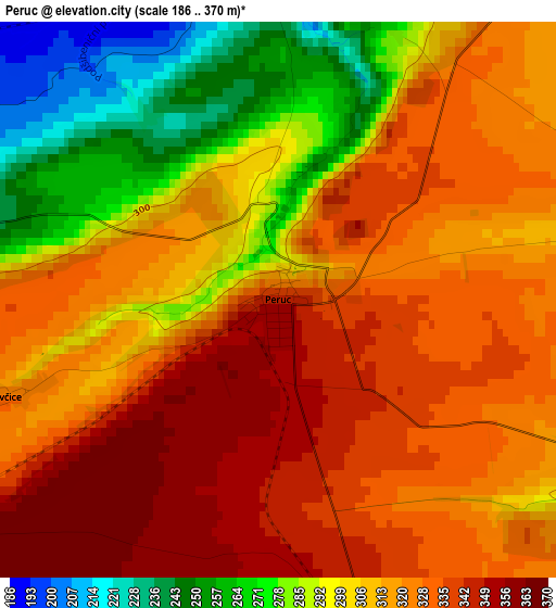
Below is the Elevation map of Peruc, which displays elevation range with different colors. Scale of the first map is from 186 to 370 m (610 to 1214 ft) with average elevation of 313.3 meters (=1028 ft) [note 1]
These maps also provides idea of topography and contour of this city, they are displayed at different zoom levels. More info about maps, scale and edge coordinates you can find below images.
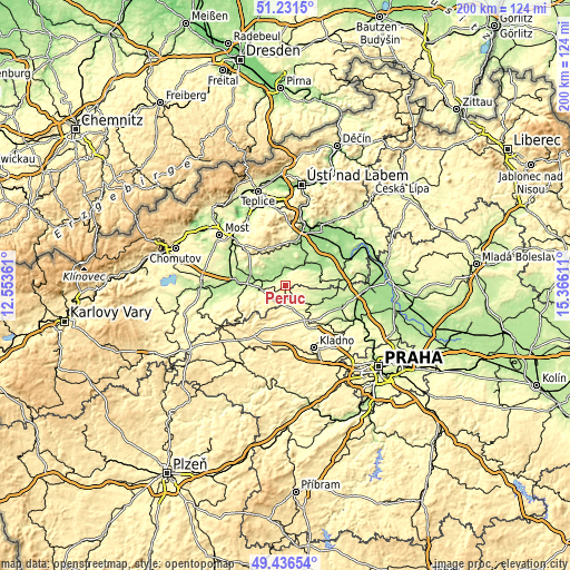
| \ | Map #1 | Topo.Map |
| Scale [m] | 186..370 m | × |
| Scale [ft] | 610..1214 ft | × |
| Average | 313.3 m = 1028 ft | × |
| Width | 6.24 km = 3.9 mi | 199.6 km = 124 mi |
| Height | 6.24 km = 3.9 mi | 199.6 km = 124 mi |
| ↑Max Latitude | 50.370537° | 51.2315° |
| Latitude at center | 50.3425° | 50.3425° |
| ↓Min Latitude | 50.314446° | 49.43654° |
| ← Min Longitude | 13.915915° | 12.55361° |
| Longitude center | 13.95986° | 13.95986° |
| →Max Longitude | 14.003805° | 15.36611° |
Nearby cities:
Cities around Peruc sort by population:
• Louny elevation 204 m
11.7 km,  277°
277°
• Slaný 282 m
15.4 km,  144°
144°
• Libochovice 170 m
9.3 km,  40°
40°
• Zlonice 224 m
11.2 km,  123°
123°
• Budyně nad Ohří 166 m
13.6 km,  59°
59°
• Smečno 374 m
18.1 km,  161°
161°
• Třebenice 228 m
15 km,  8°
8°
• Černčice 185 m
8.4 km, 284°
• Dobroměřice 184 m
12.1 km, 284°
• Čížkovice 182 m
16.5 km,  17°
17°
• Lenešice 182 m
14.2 km, 284°
• Klobuky 265 m
5.7 km, 160°
Multilingual:
 En español:
Peruc elevación 346 m.
 En France:
Peruc élévation 346 m.


Sources and notes:
- [note 1] Map square and city borders are not equal. Map elevation data is calculated only from area inside that square.
- [src 1] Elevation data from geonames database provided with same terms of usage.
- [src 2] The elevation map of Peruc is generated using elevation data from NASA's 3 arcsec (90m) resolution SRTM data.
- [src 3] Base (background) map © OpenStreetMap contributors tiles are generated by Geofabrik and OpenTopoMap.
Copyright & License:
This Peruc Elevation Map is licensed under CC BY-SA. You may reuse any part from this page, if you give a proper credit by linking to this URL:
 More info on terms of use page.