Louny elevation
Louny (Ústecký kraj, Okres Louny), Czech Republic elevation is 204 meters and Louny elevation in feet is 669 ft above sea level [src 1]. Louny is a populated place (feature code) with elevation that is 141 meters (463 ft) smaller than average city elevation in Czech Republic.
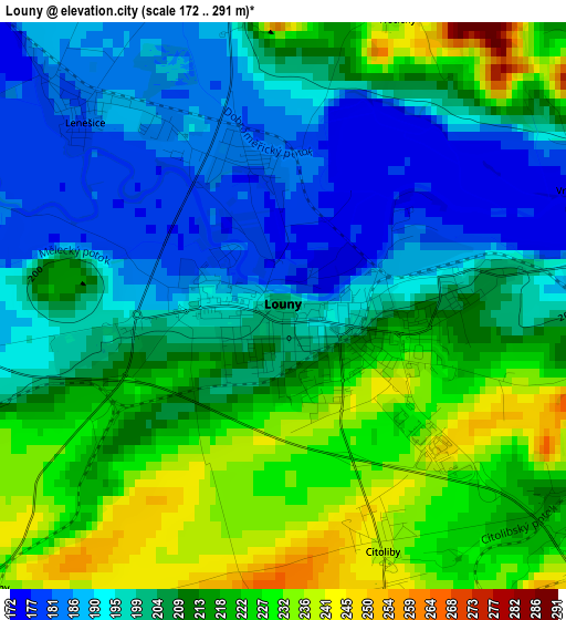
Below is the Elevation map of Louny, which displays elevation range with different colors. Scale of the first map is from 172 to 291 m (564 to 955 ft) with average elevation of 208.3 meters (=683 ft) [note 1]
These maps also provides idea of topography and contour of this city, they are displayed at different zoom levels. More info about maps, scale and edge coordinates you can find below images.
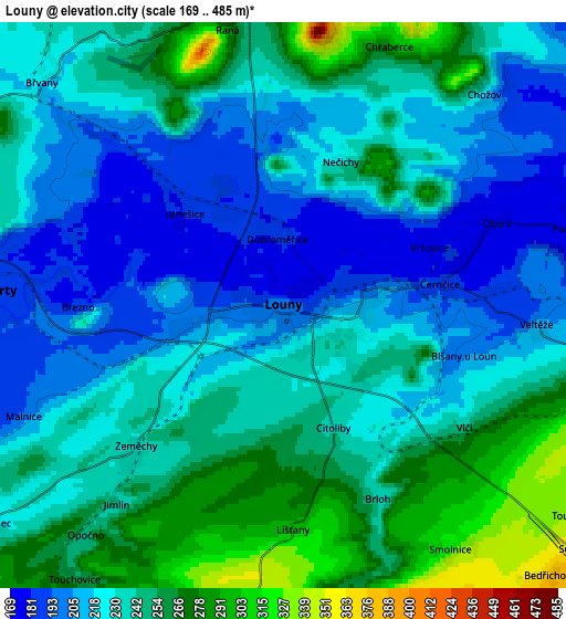
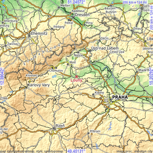
| \ | Map #1 | Map #2 | Topo.Map |
| Scale [m] | 172..291 m | 169..485 m | × |
| Scale [ft] | 564..955 ft | 554..1591 ft | × |
| Average | 208.3 m = 683 ft | 233.7 m = 767 ft | × |
| Width | 6.23 km = 3.9 mi | 12.47 km = 7.7 mi | 199.5 km = 124 mi |
| Height | 6.23 km = 3.9 mi | 12.47 km = 7.7 mi | 199.5 km = 124 mi |
| ↑Max Latitude | 50.385019° | 50.413031° | 51.24572° |
| Latitude at center | 50.35699° | 50.35699° | 50.35699° |
| ↓Min Latitude | 50.328945° | 50.300882° | 49.45131° |
| ← Min Longitude | 13.752725° | 13.708779° | 12.39042° |
| Longitude center | 13.79667° | 13.79667° | 13.79667° |
| →Max Longitude | 13.840615° | 13.884561° | 15.20292° |
Nearby cities:
Cities around Louny sort by population:
• Žatec elevation 243 m
18.1 km,  259°
259°
• Postoloprty 193 m
6.7 km,  272°
272°
• Libochovice 170 m
18.4 km,  72°
72°
• Obrnice 222 m
18 km,  336°
336°
• Peruc 346 m
11.7 km,  97°
97°
• Bečov 256 m
11.7 km,  331°
331°
• Třebenice 228 m
19.1 km,  45°
45°
• Černčice 185 m
3.5 km,  81°
81°
• Řevničov 463 m
19.2 km,  177°
177°
• Dobroměřice 184 m
1.5 km,  354°
354°
• Lenešice 182 m
3 km,  312°
312°
• Klobuky 265 m
15.2 km,  117°
117°
Multilingual:
 En español:
Louny elevación 204 m.
 En France:
Louny élévation 204 m.
 Auf Deutsch:
Laun, Louny höhe über dem Meeresspiegel ist 204 m.

Sources and notes:
- [note 1] Map square and city borders are not equal. Map elevation data is calculated only from area inside that square.
- [src 1] Elevation data from geonames database provided with same terms of usage.
- [src 2] The elevation map of Louny is generated using elevation data from NASA's 3 arcsec (90m) resolution SRTM data.
- [src 3] Base (background) map © OpenStreetMap contributors tiles are generated by Geofabrik and OpenTopoMap.
Copyright & License:
This Louny Elevation Map is licensed under CC BY-SA. You may reuse any part from this page, if you give a proper credit by linking to this URL:
 More info on terms of use page.