Podbořany elevation
Podbořany (Ústecký kraj, Okres Louny), Czech Republic elevation is 328 meters and Podbořany elevation in feet is 1076 ft above sea level [src 1]. Podbořany is a populated place (feature code) with elevation that is 17 meters (56 ft) smaller than average city elevation in Czech Republic.
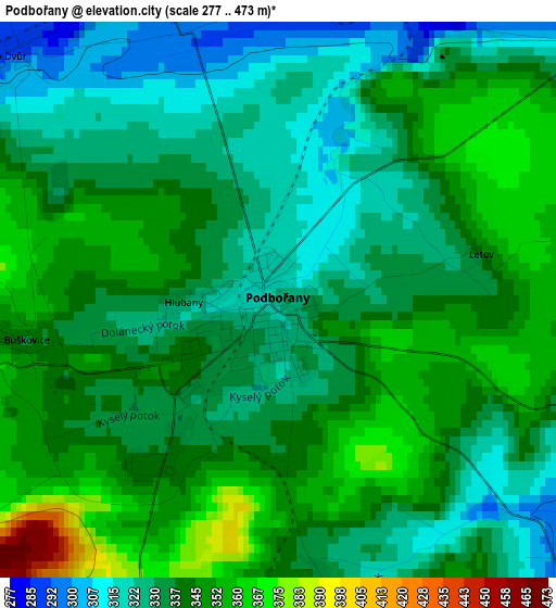
Below is the Elevation map of Podbořany, which displays elevation range with different colors. Scale of the first map is from 277 to 473 m (909 to 1552 ft) with average elevation of 337.9 meters (=1109 ft) [note 1]
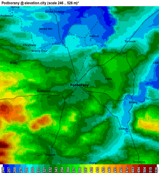
These maps also provides idea of topography and contour of this city, they are displayed at different zoom levels. More info about maps, scale and edge coordinates you can find below images.
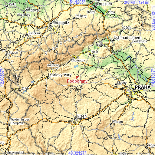
| \ | Map #1 | Map #2 | Topo.Map |
| Scale [m] | 277..473 m | 246..526 m | × |
| Scale [ft] | 909..1552 ft | 807..1726 ft | × |
| Average | 337.9 m = 1109 ft | 333.9 m = 1095 ft | × |
| Width | 6.25 km = 3.9 mi | 12.5 km = 7.8 mi | 200.1 km = 124.3 mi |
| Height | 6.25 km = 3.9 mi | 12.5 km = 7.8 mi | 200 km = 124.3 mi |
| ↑Max Latitude | 50.257474° | 50.285562° | 51.1205° |
| Latitude at center | 50.22937° | 50.22937° | 50.22937° |
| ↓Min Latitude | 50.201249° | 50.173112° | 49.32127° |
| ← Min Longitude | 13.367975° | 13.324029° | 12.00567° |
| Longitude center | 13.41192° | 13.41192° | 13.41192° |
| →Max Longitude | 13.455865° | 13.499811° | 14.81817° |
Nearby cities:
Cities around Podbořany sort by population:
• Žatec elevation 243 m
14.4 km,  41°
41°
• Kadaň 302 m
20 km,  328°
328°
• Žlutice 520 m
23.4 km,  229°
229°
• Kryry 305 m
6.2 km,  170°
170°
• Vroutek 332 m
5.9 km,  202°
202°
• Jesenice 464 m
15.3 km,  164°
164°
• Lubenec 378 m
12.9 km,  213°
213°
• Žihle 442 m
20.7 km,  187°
187°
• Březno 279 m
19.2 km,  1°
1°
• Radonice 327 m
11.8 km,  310°
310°
• Údlice 290 m
23.7 km,  7°
7°
• Měcholupy 253 m
9.8 km,  65°
65°
Multilingual:
 En español:
Podbořany elevación 328 m.
 En France:
Podbořany élévation 328 m.
 Auf Deutsch:
Podbořany höhe über dem Meeresspiegel ist 328 m.

Sources and notes:
- [note 1] Map square and city borders are not equal. Map elevation data is calculated only from area inside that square.
- [src 1] Elevation data from geonames database provided with same terms of usage.
- [src 2] The elevation map of Podbořany is generated using elevation data from NASA's 3 arcsec (90m) resolution SRTM data.
- [src 3] Base (background) map © OpenStreetMap contributors tiles are generated by Geofabrik and OpenTopoMap.
Copyright & License:
This Podbořany Elevation Map is licensed under CC BY-SA. You may reuse any part from this page, if you give a proper credit by linking to this URL:
 More info on terms of use page.