Přerov nad Labem elevation
Přerov nad Labem (Central Bohemia, Okres Nymburk), Czech Republic elevation is 180 meters and Přerov nad Labem elevation in feet is 591 ft above sea level [src 1]. Přerov nad Labem is a populated place (feature code) with elevation that is 165 meters (541 ft) smaller than average city elevation in Czech Republic.
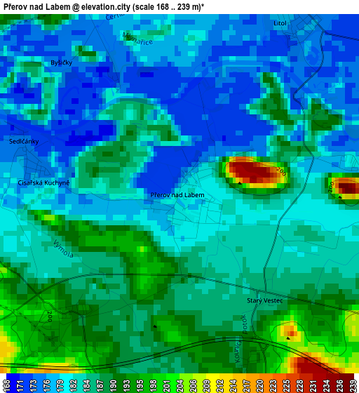
Below is the Elevation map of Přerov nad Labem, which displays elevation range with different colors. Scale of the first map is from 168 to 239 m (551 to 784 ft) with average elevation of 184 meters (=604 ft) [note 1]
These maps also provides idea of topography and contour of this city, they are displayed at different zoom levels. More info about maps, scale and edge coordinates you can find below images.
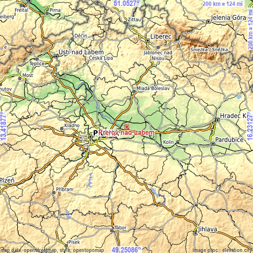
| \ | Map #1 | Topo.Map |
| Scale [m] | 168..239 m | × |
| Scale [ft] | 551..784 ft | × |
| Average | 184 m = 604 ft | × |
| Width | 6.26 km = 3.9 mi | 200.3 km = 124.5 mi |
| Height | 6.26 km = 3.9 mi | 200.3 km = 124.5 mi |
| ↑Max Latitude | 50.188415° | 51.0527° |
| Latitude at center | 50.16027° | 50.16027° |
| ↓Min Latitude | 50.132108° | 49.25086° |
| ← Min Longitude | 14.781075° | 13.41877° |
| Longitude center | 14.82502° | 14.82502° |
| →Max Longitude | 14.868965° | 16.23127° |
Nearby cities:
Cities around Přerov nad Labem sort by population:
• Brandýs nad Labem-Stará Boleslav elevation 186 m
11.9 km,  284°
284°
• Čelákovice 181 m
5.3 km,  270°
270°
• Lysá nad Labem 189 m
4.6 km,  6°
6°
• Český Brod 223 m
9.9 km,  165°
165°
• Milovice 190 m
8.6 km,  31°
31°
• Úvaly 249 m
11.7 km,  214°
214°
• Sadská 188 m
11.8 km,  103°
103°
• Zeleneč 257 m
12.1 km,  255°
255°
• Šestajovice 261 m
11.8 km,  240°
240°
• Jirny 249 m
10.2 km, 241°
• Poříčany 205 m
8.8 km,  131°
131°
• Nehvizdy 242 m
7.5 km, 244°
Multilingual:
 En español:
Přerov nad Labem elevación 180 m.
 En France:
Přerov nad Labem élévation 180 m.
 Auf Deutsch:
Přerov nad Labem höhe über dem Meeresspiegel ist 180 m.

Sources and notes:
- [note 1] Map square and city borders are not equal. Map elevation data is calculated only from area inside that square.
- [src 1] Elevation data from geonames database provided with same terms of usage.
- [src 2] The elevation map of Přerov nad Labem is generated using elevation data from NASA's 3 arcsec (90m) resolution SRTM data.
- [src 3] Base (background) map © OpenStreetMap contributors tiles are generated by Geofabrik and OpenTopoMap.
Copyright & License:
This Přerov nad Labem Elevation Map is licensed under CC BY-SA. You may reuse any part from this page, if you give a proper credit by linking to this URL:
 More info on terms of use page.