Stará Huť elevation
Stará Huť (Central Bohemia, Okres Příbram), Czech Republic elevation is 353 meters and Stará Huť elevation in feet is 1158 ft above sea level [src 1]. Stará Huť is a populated place (feature code) with elevation that is 8 meters (26 ft) bigger than average city elevation in Czech Republic.
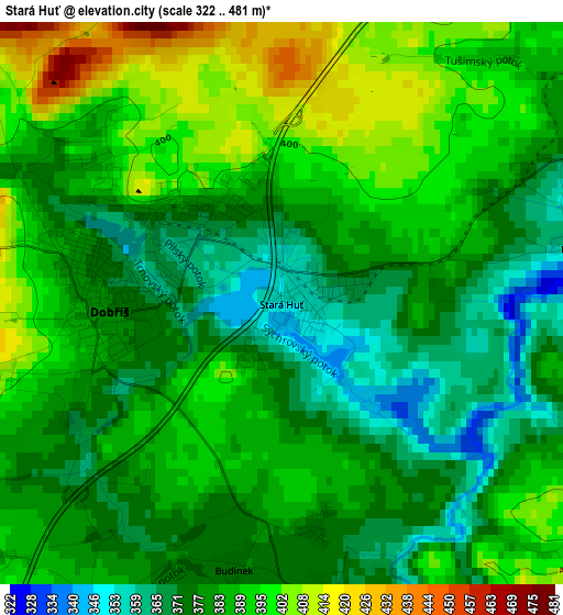
Below is the Elevation map of Stará Huť, which displays elevation range with different colors. Scale of the first map is from 322 to 481 m (1056 to 1578 ft) with average elevation of 384.3 meters (=1261 ft) [note 1]
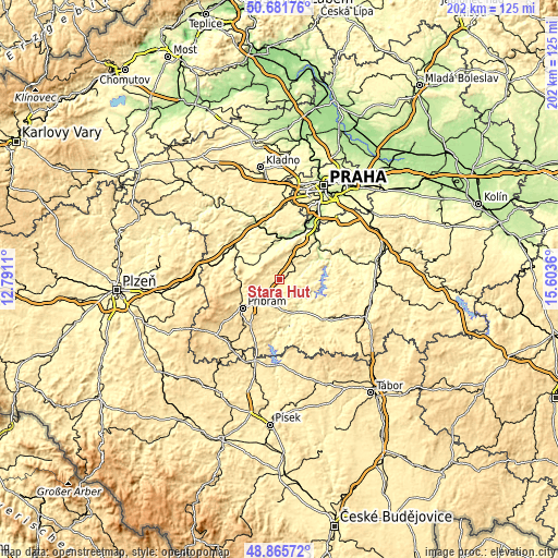
These maps also provides idea of topography and contour of this city, they are displayed at different zoom levels. More info about maps, scale and edge coordinates you can find below images.
| \ | Map #1 | Topo.Map |
| Scale [m] | 322..481 m | × |
| Scale [ft] | 1056..1578 ft | × |
| Average | 384.3 m = 1261 ft | × |
| Width | 6.31 km = 3.9 mi | 201.9 km = 125.5 mi |
| Height | 6.31 km = 3.9 mi | 201.9 km = 125.5 mi |
| ↑Max Latitude | 49.810617° | 50.68176° |
| Latitude at center | 49.78225° | 49.78225° |
| ↓Min Latitude | 49.753866° | 48.86572° |
| ← Min Longitude | 14.153405° | 12.7911° |
| Longitude center | 14.19735° | 14.19735° |
| →Max Longitude | 14.241295° | 15.6036° |
Nearby cities:
Cities around Stará Huť sort by population:
• Příbram elevation 510 m
16.9 km,  232°
232°
• Dobříš 382 m
2.2 km,  266°
266°
• Mníšek pod Brdy 384 m
10.4 km,  26°
26°
• Řevnice 221 m
14.9 km,  10°
10°
• Dobřichovice 205 m
17.1 km,  18°
18°
• Jince 391 m
15.7 km, 271°
• Nový Knín 312 m
6.9 km,  84°
84°
• Hostomice 367 m
11.9 km,  293°
293°
• Všenory 237 m
18 km, 25°
• Štěchovice 213 m
16.8 km,  62°
62°
• Hradištko 284 m
18 km, 57°
• Lochovice 302 m
17.4 km,  296°
296°
Multilingual:
 En español:
Stará Huť elevación 353 m.
 En France:
Stará Huť élévation 353 m.
 Auf Deutsch:
Stará Huť höhe über dem Meeresspiegel ist 353 m.

Sources and notes:
- [note 1] Map square and city borders are not equal. Map elevation data is calculated only from area inside that square.
- [src 1] Elevation data from geonames database provided with same terms of usage.
- [src 2] The elevation map of Stará Huť is generated using elevation data from NASA's 3 arcsec (90m) resolution SRTM data.
- [src 3] Base (background) map © OpenStreetMap contributors tiles are generated by Geofabrik and OpenTopoMap.
Copyright & License:
This Stará Huť Elevation Map is licensed under CC BY-SA. You may reuse any part from this page, if you give a proper credit by linking to this URL:
 More info on terms of use page.