Vacov elevation
Vacov (Jihočeský kraj, Okres Prachatice), Czech Republic elevation is 731 meters and Vacov elevation in feet is 2398 ft above sea level [src 1]. Vacov is a populated place (feature code) with elevation that is 386 meters (1266 ft) bigger than average city elevation in Czech Republic.
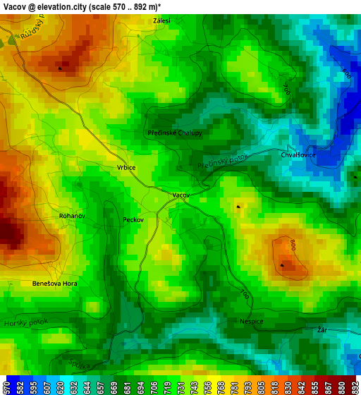
Below is the Elevation map of Vacov, which displays elevation range with different colors. Scale of the first map is from 570 to 892 m (1870 to 2927 ft) with average elevation of 715.1 meters (=2346 ft) [note 1]
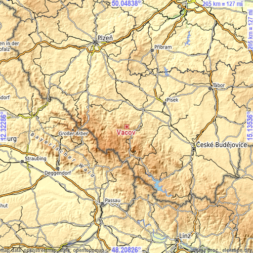
These maps also provides idea of topography and contour of this city, they are displayed at different zoom levels. More info about maps, scale and edge coordinates you can find below images.
| \ | Map #1 | Topo.Map |
| Scale [m] | 570..892 m | × |
| Scale [ft] | 1870..2927 ft | × |
| Average | 715.1 m = 2346 ft | × |
| Width | 6.39 km = 4 mi | 204.6 km = 127.1 mi |
| Height | 6.39 km = 4 mi | 204.6 km = 127.1 mi |
| ↑Max Latitude | 49.165603° | 50.04838° |
| Latitude at center | 49.13686° | 49.13686° |
| ↓Min Latitude | 49.1081° | 48.20826° |
| ← Min Longitude | 13.685165° | 12.32286° |
| Longitude center | 13.72911° | 13.72911° |
| →Max Longitude | 13.773055° | 15.13536° |
Nearby cities:
Cities around Vacov sort by population:
• Strakonice elevation 403 m
18.7 km,  42°
42°
• Sušice 477 m
18.4 km,  304°
304°
• Vimperk 659 m
9.5 km,  155°
155°
• Volyně 463 m
11.9 km,  74°
74°
• Vlachovo Březí 552 m
17.8 km,  110°
110°
• Zdíkov 731 m
6.3 km,  201°
201°
• Kašperské Hory 733 m
12.6 km,  273°
273°
• Čkyně 527 m
7.7 km, 108°
• Katovice 409 m
16.9 km,  25°
25°
• Stachy 746 m
6 km,  229°
229°
• Hartmanice 718 m
20.3 km,  280°
280°
• Borová Lada 901 m
17.1 km, 197°
Multilingual:
 En español:
Vacov elevación 731 m.
 En France:
Vacov élévation 731 m.


Sources and notes:
- [note 1] Map square and city borders are not equal. Map elevation data is calculated only from area inside that square.
- [src 1] Elevation data from geonames database provided with same terms of usage.
- [src 2] The elevation map of Vacov is generated using elevation data from NASA's 3 arcsec (90m) resolution SRTM data.
- [src 3] Base (background) map © OpenStreetMap contributors tiles are generated by Geofabrik and OpenTopoMap.
Copyright & License:
This Vacov Elevation Map is licensed under CC BY-SA. You may reuse any part from this page, if you give a proper credit by linking to this URL:
 More info on terms of use page.