Zastávka elevation
Zastávka (South Moravian, Okres Brno-venkov), Czech Republic elevation is 319 meters and Zastávka elevation in feet is 1047 ft above sea level [src 1]. Zastávka is a populated place (feature code) with elevation that is 26 meters (85 ft) smaller than average city elevation in Czech Republic.
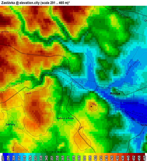
Below is the Elevation map of Zastávka, which displays elevation range with different colors. Scale of the first map is from 291 to 465 m (955 to 1526 ft) with average elevation of 370.8 meters (=1217 ft) [note 1]
These maps also provides idea of topography and contour of this city, they are displayed at different zoom levels. More info about maps, scale and edge coordinates you can find below images.
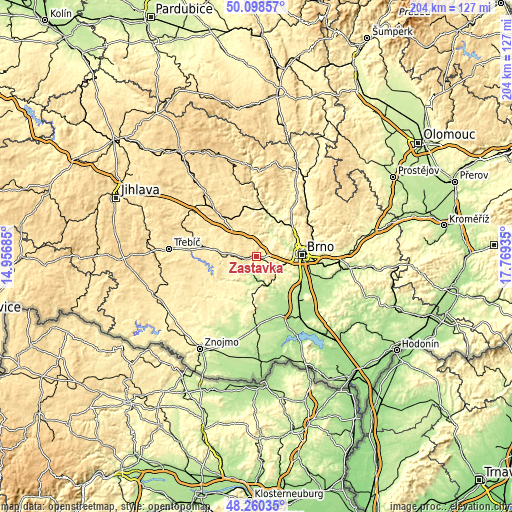
| \ | Map #1 | Topo.Map |
| Scale [m] | 291..465 m | × |
| Scale [ft] | 955..1526 ft | × |
| Average | 370.8 m = 1217 ft | × |
| Width | 6.39 km = 4 mi | 204.4 km = 127 mi |
| Height | 6.39 km = 4 mi | 204.4 km = 127 mi |
| ↑Max Latitude | 49.216713° | 50.09857° |
| Latitude at center | 49.188° | 49.188° |
| ↓Min Latitude | 49.15927° | 48.26035° |
| ← Min Longitude | 16.319155° | 14.95685° |
| Longitude center | 16.3631° | 16.3631° |
| →Max Longitude | 16.407045° | 17.76935° |
Nearby cities:
Cities around Zastávka sort by population:
• Ivančice elevation 212 m
9.7 km,  173°
173°
• Rosice 339 m
1.9 km,  109°
109°
• Velká Bíteš 477 m
14.9 km,  318°
318°
• Oslavany 218 m
7.4 km,  195°
195°
• Zbýšov 351 m
3.8 km, 195°
• Veverská Bítýška 235 m
11.1 km,  28°
28°
• Střelice 273 m
11 km, 111°
• Ořechov 296 m
14.4 km,  126°
126°
• Troubsko 267 m
10.9 km,  100°
100°
• Říčany 349 m
3.7 km,  36°
36°
• Ostopovice 238 m
13.6 km, 102°
• Zbraslav 464 m
6.2 km,  306°
306°
Multilingual:
 En español:
Zastávka elevación 319 m.
 En France:
Zastávka élévation 319 m.
 Auf Deutsch:
Zastávka höhe über dem Meeresspiegel ist 319 m.

Sources and notes:
- [note 1] Map square and city borders are not equal. Map elevation data is calculated only from area inside that square.
- [src 1] Elevation data from geonames database provided with same terms of usage.
- [src 2] The elevation map of Zastávka is generated using elevation data from NASA's 3 arcsec (90m) resolution SRTM data.
- [src 3] Base (background) map © OpenStreetMap contributors tiles are generated by Geofabrik and OpenTopoMap.
Copyright & License:
This Zastávka Elevation Map is licensed under CC BY-SA. You may reuse any part from this page, if you give a proper credit by linking to this URL:
 More info on terms of use page.