Mindelo elevation
Mindelo (São Vicente), Cape Verde elevation is 44 meters and Mindelo elevation in feet is 144 ft above sea level [src 1]. Mindelo is a seat of a first-order administrative division (feature code) with elevation that is 74 meters (243 ft) smaller than average city elevation in Cape Verde.
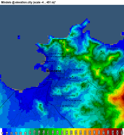
Below is the Elevation map of Mindelo, which displays elevation range with different colors. Scale of the first map is from -4 to 451 m (-13 to 1480 ft) with average elevation of 82.2 meters (=270 ft) [note 1]
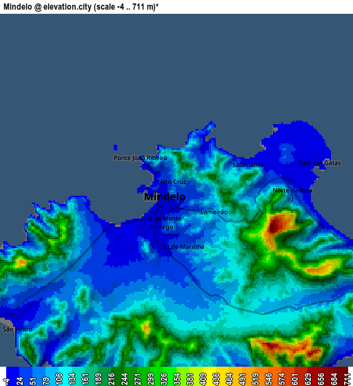
These maps also provides idea of topography and contour of this city, they are displayed at different zoom levels. More info about maps, scale and edge coordinates you can find below images.
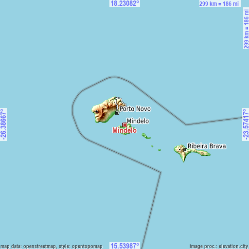
| \ | Map #1 | Map #2 | Topo.Map |
| Scale [m] | -4..451 m | -4..711 m | × |
| Scale [ft] | -13..1480 ft | -13..2333 ft | × |
| Average | 82.2 m = 270 ft | 126.7 m = 416 ft | × |
| Width | 9.35 km = 5.8 mi | 18.7 km = 11.6 mi | 299.2 km = 185.9 mi |
| Height | 9.35 km = 5.8 mi | 18.7 km = 11.6 mi | 299.2 km = 185.9 mi |
| ↑Max Latitude | 16.932185° | 16.974221° | 18.23082° |
| Latitude at center | 16.89014° | 16.89014° | 16.89014° |
| ↓Min Latitude | 16.848086° | 16.806022° | 15.53987° |
| ← Min Longitude | -25.024365° | -25.068311° | -26.38667° |
| Longitude center | -24.98042° | -24.98042° | -24.98042° |
| →Max Longitude | -24.936475° | -24.892529° | -23.57417° |
Nearby cities:
Cities around Mindelo sort by population:
• Santa Maria elevation 5 m
223.3 km,  98°
98°
• São Filipe 103 m
227.7 km,  166°
166°
• Tarrafal 17 m
222.1 km,  143°
143°
• Espargos 53 m
217.2 km,  93°
93°
• Porto Novo 9 m
17 km,  328°
328°
• Ribeira Brava 296 m
78.8 km,  112°
112°
• Tarrafal de São Nicolau 4 m
75.4 km,  118°
118°
• Ponta do Sol 22 m
36.6 km,  341°
341°
• Ribeira Grande 41 m
33.7 km, 344°
• Pombas 191 m
29.2 km,  351°
351°
• Nova Sintra 83 m
226.5 km, 172°
• Igreja 15 m
218 km,  161°
161°
Multilingual:
 En español:
Mindelo elevación 44 m.
 En France:
Mindelo élévation 44 m.


Sources and notes:
- [note 1] Map square and city borders are not equal. Map elevation data is calculated only from area inside that square.
- [src 1] Elevation data from geonames database provided with same terms of usage.
- [src 2] The elevation map of Mindelo is generated using elevation data from NASA's 3 arcsec (90m) resolution SRTM data.
- [src 3] Base (background) map © OpenStreetMap contributors tiles are generated by Geofabrik and OpenTopoMap.
Copyright & License:
This Mindelo Elevation Map is licensed under CC BY-SA. You may reuse any part from this page, if you give a proper credit by linking to this URL:
 More info on terms of use page.