Ponta do Sol elevation
Ponta do Sol (Ribeira Grande), Cape Verde elevation is 22 meters and Ponta do Sol elevation in feet is 72 ft above sea level [src 1]. Ponta do Sol is a populated place (feature code) with elevation that is 96 meters (315 ft) smaller than average city elevation in Cape Verde.
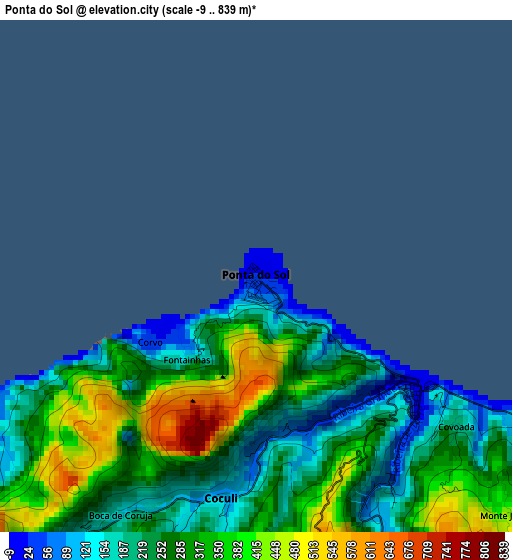
Below is the Elevation map of Ponta do Sol, which displays elevation range with different colors. Scale of the first map is from -9 to 839 m (-30 to 2753 ft) with average elevation of 280.5 meters (=920 ft) [note 1]
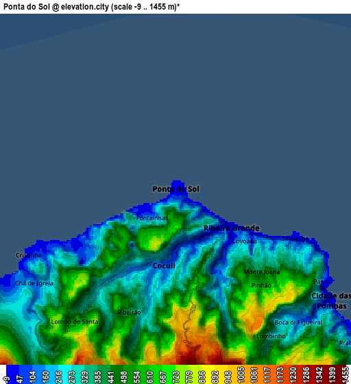
These maps also provides idea of topography and contour of this city, they are displayed at different zoom levels. More info about maps, scale and edge coordinates you can find below images.
| \ | Map #1 | Map #2 | Topo.Map |
| Scale [m] | -9..839 m | -9..1455 m | × |
| Scale [ft] | -30..2753 ft | -30..4774 ft | × |
| Average | 280.5 m = 920 ft | 448 m = 1470 ft | × |
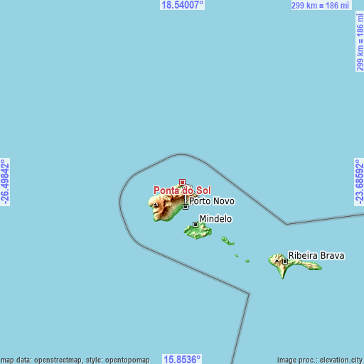
| Width | 9.34 km = 5.8 mi | 18.67 km = 11.6 mi | 298.7 km = 185.6 mi |
| Height | 9.34 km = 5.8 mi | 18.67 km = 11.6 mi | 298.7 km = 185.6 mi |
| ↑Max Latitude | 17.243685° | 17.28565° | 18.54007° |
| Latitude at center | 17.20171° | 17.20171° | 17.20171° |
| ↓Min Latitude | 17.159726° | 17.117732° | 15.8536° |
| ← Min Longitude | -25.136115° | -25.180061° | -26.49842° |
| Longitude center | -25.09217° | -25.09217° | -25.09217° |
| →Max Longitude | -25.048225° | -25.004279° | -23.68592° |
Nearby cities:
Cities around Ponta do Sol sort by population:
• Mindelo elevation 44 m
36.6 km,  161°
161°
• Santa Maria 5 m
242.2 km,  106°
106°
• Tarrafal 17 m
257.3 km,  146°
146°
• Espargos 53 m
233.7 km,  102°
102°
• Porto Novo 9 m
20.4 km,  171°
171°
• Ribeira Brava 296 m
106.7 km,  127°
127°
• Tarrafal de São Nicolau 4 m
105.3 km, 132°
• Ribeira Grande 41 m
3.6 km, 126°
• Sal Rei 1 m
258.2 km,  116°
116°
• Pombas 191 m
9.6 km, 126°
• Nova Sintra 83 m
262.6 km, 170°
• Igreja 15 m
254.6 km, 161°
Multilingual:
 En español:
Ponta do Sol elevación 22 m.
 En France:
Ponta do Sol élévation 22 m.
 Auf Deutsch:
Ponta do Sol höhe über dem Meeresspiegel ist 22 m.

Sources and notes:
- [note 1] Map square and city borders are not equal. Map elevation data is calculated only from area inside that square.
- [src 1] Elevation data from geonames database provided with same terms of usage.
- [src 2] The elevation map of Ponta do Sol is generated using elevation data from NASA's 3 arcsec (90m) resolution SRTM data.
- [src 3] Base (background) map © OpenStreetMap contributors tiles are generated by Geofabrik and OpenTopoMap.
Copyright & License:
This Ponta do Sol Elevation Map is licensed under CC BY-SA. You may reuse any part from this page, if you give a proper credit by linking to this URL:
 More info on terms of use page.