Contramaestre elevation
Contramaestre (Santiago de Cuba), Cuba elevation is 114 meters and Contramaestre elevation in feet is 374 ft above sea level [src 1]. Contramaestre is a seat of a second-order administrative division (feature code) with elevation that is 45 meters (148 ft) bigger than average city elevation in Cuba.
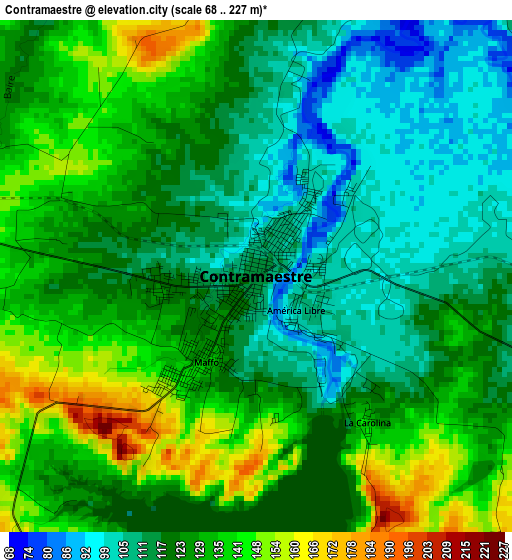
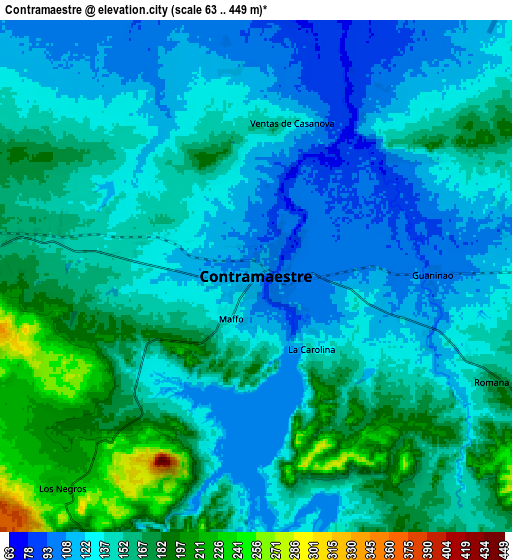
Below is the Elevation map of Contramaestre, which displays elevation range with different colors. Scale of the first map is from 68 to 227 m (223 to 745 ft) with average elevation of 123.9 meters (=406 ft) [note 1]
These maps also provides idea of topography and contour of this city, they are displayed at different zoom levels. More info about maps, scale and edge coordinates you can find below images.
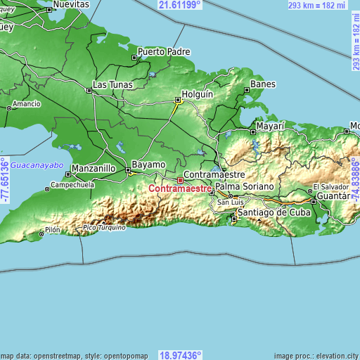
| \ | Map #1 | Map #2 | Topo.Map |
| Scale [m] | 68..227 m | 63..449 m | × |
| Scale [ft] | 223..745 ft | 207..1473 ft | × |
| Average | 123.9 m = 406 ft | 145.5 m = 477 ft | × |
| Width | 9.17 km = 5.7 mi | 18.33 km = 11.4 mi | 293.3 km = 182.2 mi |
| Height | 9.17 km = 5.7 mi | 18.33 km = 11.4 mi | 293.3 km = 182.2 mi |
| ↑Max Latitude | 20.340001° | 20.3812° | 21.61199° |
| Latitude at center | 20.29879° | 20.29879° | 20.29879° |
| ↓Min Latitude | 20.257568° | 20.216336° | 18.97436° |
| ← Min Longitude | -76.289055° | -76.333001° | -77.65136° |
| Longitude center | -76.24511° | -76.24511° | -76.24511° |
| →Max Longitude | -76.201165° | -76.157219° | -74.83886° |
Nearby cities:
Cities around Contramaestre sort by population:
• Santiago de Cuba elevation 46 m
53.5 km,  125°
125°
• Bayamo 58 m
42.4 km,  281°
281°
• Palma Soriano 152 m
28 km,  110°
110°
• San Luis 201 m
43 km, 106°
• San Germán 98 m
35.5 km,  19°
19°
• Cacocum 74 m
49.5 km,  350°
350°
• Jiguaní 122 m
20.5 km,  291°
291°
• Cueto 61 m
50.9 km,  40°
40°
• Cauto Cristo 51 m
37.2 km,  320°
320°
• Guisa 201 m
31.1 km,  260°
260°
• El Cobre 102 m
41.8 km, 131°
• Báguanos 84 m
55.2 km, 24°
Multilingual:
 En español:
Contramaestre elevación 114 m.
 En France:
Contramaestre élévation 114 m.
 Auf Deutsch:
Contramaestre höhe über dem Meeresspiegel ist 114 m.

Sources and notes:
- [note 1] Map square and city borders are not equal. Map elevation data is calculated only from area inside that square.
- [src 1] Elevation data from geonames database provided with same terms of usage.
- [src 2] The elevation map of Contramaestre is generated using elevation data from NASA's 3 arcsec (90m) resolution SRTM data.
- [src 3] Base (background) map © OpenStreetMap contributors tiles are generated by Geofabrik and OpenTopoMap.
Copyright & License:
This Contramaestre Elevation Map is licensed under CC BY-SA. You may reuse any part from this page, if you give a proper credit by linking to this URL:
 More info on terms of use page.