Palma Soriano elevation
Palma Soriano (Santiago de Cuba), Cuba elevation is 152 meters and Palma Soriano elevation in feet is 499 ft above sea level [src 1]. Palma Soriano is a seat of a second-order administrative division (feature code) with elevation that is 83 meters (272 ft) bigger than average city elevation in Cuba.
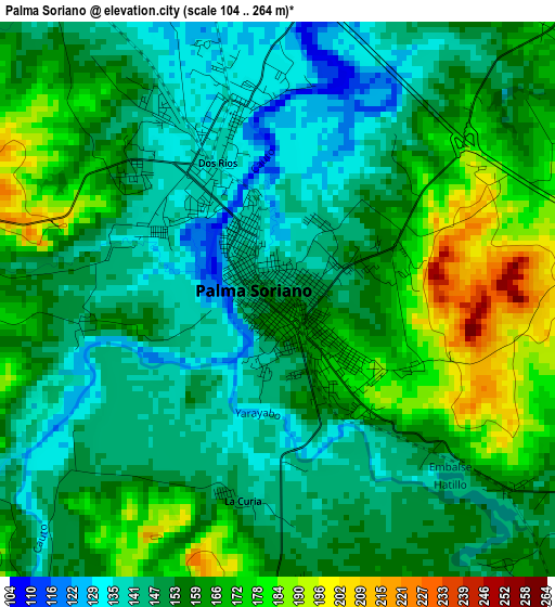
Below is the Elevation map of Palma Soriano, which displays elevation range with different colors. Scale of the first map is from 104 to 264 m (341 to 866 ft) with average elevation of 156.2 meters (=512 ft) [note 1]
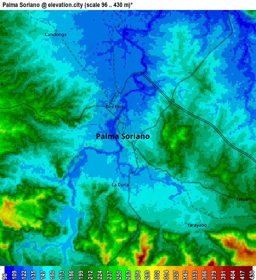
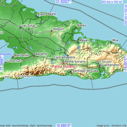
These maps also provides idea of topography and contour of this city, they are displayed at different zoom levels. More info about maps, scale and edge coordinates you can find below images.
| \ | Map #1 | Map #2 | Topo.Map |
| Scale [m] | 104..264 m | 96..430 m | × |
| Scale [ft] | 341..866 ft | 315..1411 ft | × |
| Average | 156.2 m = 512 ft | 173.6 m = 570 ft | × |
| Width | 9.17 km = 5.7 mi | 18.34 km = 11.4 mi | 293.4 km = 182.3 mi |
| Height | 9.17 km = 5.7 mi | 18.34 km = 11.4 mi | 293.5 km = 182.4 mi |
| ↑Max Latitude | 20.252534° | 20.293757° | 21.52527° |
| Latitude at center | 20.2113° | 20.2113° | 20.2113° |
| ↓Min Latitude | 20.170055° | 20.128799° | 18.88615° |
| ← Min Longitude | -76.037565° | -76.081511° | -77.39987° |
| Longitude center | -75.99362° | -75.99362° | -75.99362° |
| →Max Longitude | -75.949675° | -75.905729° | -74.58737° |
Nearby cities:
Cities around Palma Soriano sort by population:
• Santiago de Cuba elevation 46 m
27.4 km,  140°
140°
• Contramaestre 114 m
28 km,  290°
290°
• San Luis 201 m
15.2 km,  99°
99°
• San Germán 98 m
45.6 km,  341°
341°
• Jiguaní 122 m
48.5 km, 291°
• Cueto 61 m
49.1 km,  7°
7°
• Cauto Cristo 51 m
63 km,  307°
307°
• Guisa 201 m
57.1 km,  274°
274°
• El Cobre 102 m
18.8 km,  164°
164°
• Báguanos 84 m
60.1 km,  356°
356°
• Mayarí 19 m
59.1 km,  33°
33°
• Segundo Frente 221 m
56.5 km,  66°
66°
Multilingual:
 En español:
Palma Soriano elevación 152 m.
 En France:
Palma Soriano élévation 152 m.
 Auf Deutsch:
Palma Soriano höhe über dem Meeresspiegel ist 152 m.

Sources and notes:
- [note 1] Map square and city borders are not equal. Map elevation data is calculated only from area inside that square.
- [src 1] Elevation data from geonames database provided with same terms of usage.
- [src 2] The elevation map of Palma Soriano is generated using elevation data from NASA's 3 arcsec (90m) resolution SRTM data.
- [src 3] Base (background) map © OpenStreetMap contributors tiles are generated by Geofabrik and OpenTopoMap.
Copyright & License:
This Palma Soriano Elevation Map is licensed under CC BY-SA. You may reuse any part from this page, if you give a proper credit by linking to this URL:
 More info on terms of use page.