Bagaces elevation
Bagaces (Guanacaste), Costa Rica elevation is 84 meters and Bagaces elevation in feet is 276 ft above sea level [src 1]. Bagaces is a populated place (feature code) with elevation that is 656 meters (2152 ft) smaller than average city elevation in Costa Rica.
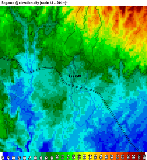
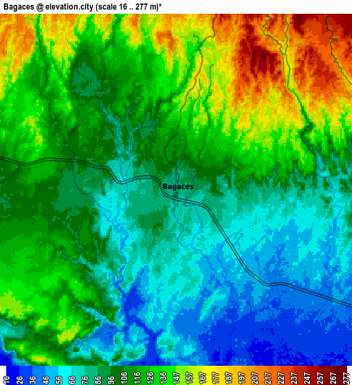
Below is the Elevation map of Bagaces, which displays elevation range with different colors. Scale of the first map is from 43 to 204 m (141 to 669 ft) with average elevation of 91.4 meters (=300 ft) [note 1]
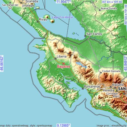
These maps also provides idea of topography and contour of this city, they are displayed at different zoom levels. More info about maps, scale and edge coordinates you can find below images.
| \ | Map #1 | Map #2 | Topo.Map |
| Scale [m] | 43..204 m | 16..277 m | × |
| Scale [ft] | 141..669 ft | 52..909 ft | × |
| Average | 91.4 m = 300 ft | 108.5 m = 356 ft | × |
| Width | 9.61 km = 6 mi | 19.22 km = 11.9 mi | 307.4 km = 191 mi |
| Height | 9.61 km = 6 mi | 19.22 km = 11.9 mi | 307.5 km = 191.1 mi |
| ↑Max Latitude | 10.568613° | 10.61181° | 11.90477° |
| Latitude at center | 10.52541° | 10.52541° | 10.52541° |
| ↓Min Latitude | 10.482201° | 10.438986° | 9.13985° |
| ← Min Longitude | -85.299315° | -85.343261° | -86.66162° |
| Longitude center | -85.25537° | -85.25537° | -85.25537° |
| →Max Longitude | -85.211425° | -85.167479° | -83.84912° |
Nearby cities:
Cities around Bagaces sort by population:
• Liberia elevation 148 m
23.4 km,  301°
301°
• San José 50 m
49.2 km,  15°
15°
• Cañas 86 m
20.1 km,  121°
121°
• Nicoya 128 m
46.9 km,  207°
207°
• Santa Cruz 58 m
46.6 km,  230°
230°
• Tilarán 545 m
32.1 km,  101°
101°
• Juntas 154 m
42.3 km,  130°
130°
• Upala 52 m
49.1 km,  32°
32°
• Sardinal 50 m
42.9 km,  268°
268°
• Belén 40 m
38.7 km,  250°
250°
• Fortuna 437 m
17.6 km, 20°
• Bijagua 434 m
31.7 km,  43°
43°
Multilingual:
 En español:
Bagaces elevación 84 m.
 En France:
Bagaces élévation 84 m.


Sources and notes:
- [note 1] Map square and city borders are not equal. Map elevation data is calculated only from area inside that square.
- [src 1] Elevation data from geonames database provided with same terms of usage.
- [src 2] The elevation map of Bagaces is generated using elevation data from NASA's 3 arcsec (90m) resolution SRTM data.
- [src 3] Base (background) map © OpenStreetMap contributors tiles are generated by Geofabrik and OpenTopoMap.
Copyright & License:
This Bagaces Elevation Map is licensed under CC BY-SA. You may reuse any part from this page, if you give a proper credit by linking to this URL:
 More info on terms of use page.