Santa Cruz elevation
Santa Cruz (Guanacaste), Costa Rica elevation is 58 meters and Santa Cruz elevation in feet is 190 ft above sea level [src 1]. Santa Cruz is a populated place (feature code) with elevation that is 682 meters (2238 ft) smaller than average city elevation in Costa Rica.
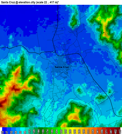
Below is the Elevation map of Santa Cruz, which displays elevation range with different colors. Scale of the first map is from 22 to 417 m (72 to 1368 ft) with average elevation of 96.1 meters (=315 ft) [note 1]
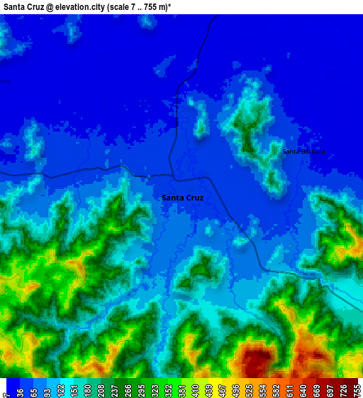
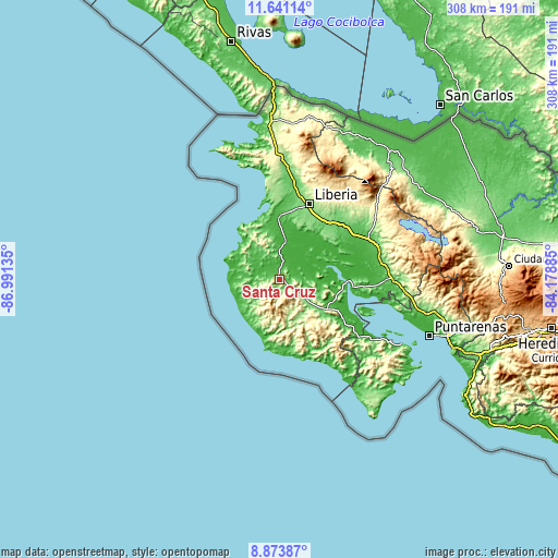
These maps also provides idea of topography and contour of this city, they are displayed at different zoom levels. More info about maps, scale and edge coordinates you can find below images.
| \ | Map #1 | Map #2 | Topo.Map |
| Scale [m] | 22..417 m | 7..755 m | × |
| Scale [ft] | 72..1368 ft | 23..2477 ft | × |
| Average | 96.1 m = 315 ft | 137.6 m = 451 ft | × |
| Width | 9.62 km = 6 mi | 19.23 km = 11.9 mi | 307.7 km = 191.2 mi |
| Height | 9.62 km = 6 mi | 19.23 km = 11.9 mi | 307.7 km = 191.2 mi |
| ↑Max Latitude | 10.30377° | 10.347003° | 11.64114° |
| Latitude at center | 10.26053° | 10.26053° | 10.26053° |
| ↓Min Latitude | 10.217285° | 10.174033° | 8.87387° |
| ← Min Longitude | -85.629045° | -85.672991° | -86.99135° |
| Longitude center | -85.5851° | -85.5851° | -85.5851° |
| →Max Longitude | -85.541155° | -85.497209° | -84.17885° |
Nearby cities:
Cities around Santa Cruz sort by population:
• Liberia elevation 148 m
44.7 km,  21°
21°
• Cañas 86 m
56.5 km,  70°
70°
• Nicoya 128 m
19.1 km,  129°
129°
• Bagaces 84 m
46.6 km,  50°
50°
• Sardinal 50 m
29.3 km,  346°
346°
• Belén 40 m
16.4 km,  358°
358°
• Hojancha 355 m
29 km,  140°
140°
• Fortuna 437 m
62.3 km,  42°
42°
• Nandayure 11 m
49.1 km,  120°
120°
• Sámara 10 m
42.6 km,  171°
171°
• Bejuco 23 m
53.5 km,  148°
148°
• Zapotal 421 m
42.6 km, 132°
Multilingual:
 En español:
Santa Cruz elevación 58 m.
 En France:
Santa Cruz élévation 58 m.
 Auf Deutsch:
Santa Cruz höhe über dem Meeresspiegel ist 58 m.

Sources and notes:
- [note 1] Map square and city borders are not equal. Map elevation data is calculated only from area inside that square.
- [src 1] Elevation data from geonames database provided with same terms of usage.
- [src 2] The elevation map of Santa Cruz is generated using elevation data from NASA's 3 arcsec (90m) resolution SRTM data.
- [src 3] Base (background) map © OpenStreetMap contributors tiles are generated by Geofabrik and OpenTopoMap.
Copyright & License:
This Santa Cruz Elevation Map is licensed under CC BY-SA. You may reuse any part from this page, if you give a proper credit by linking to this URL:
 More info on terms of use page.