Daniel Flores elevation
Daniel Flores (San José, Pérez Zeledón), Costa Rica elevation is 639 meters and Daniel Flores elevation in feet is 2096 ft above sea level [src 1]. Daniel Flores is a populated place (feature code) with elevation that is 101 meters (331 ft) smaller than average city elevation in Costa Rica.
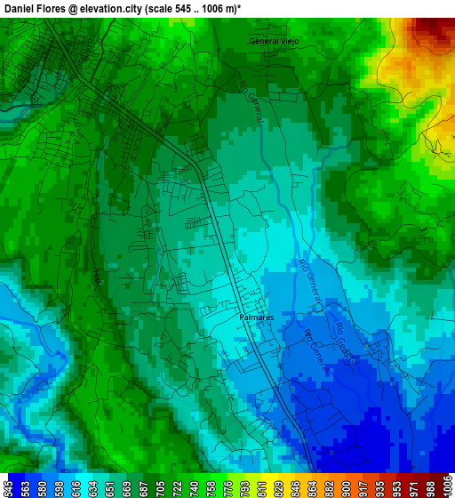
Below is the Elevation map of Daniel Flores, which displays elevation range with different colors. Scale of the first map is from 545 to 1006 m (1788 to 3301 ft) with average elevation of 675.9 meters (=2218 ft) [note 1]
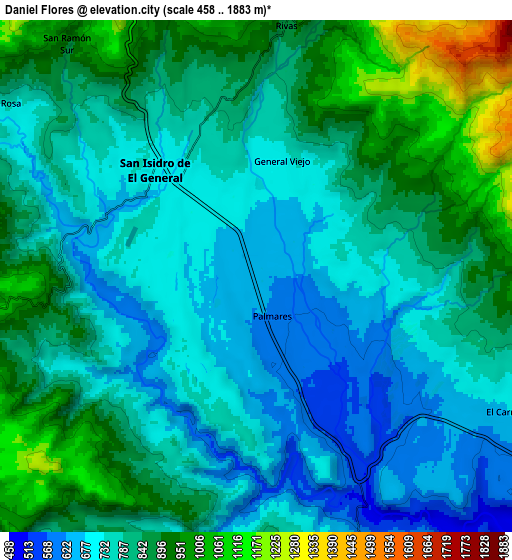
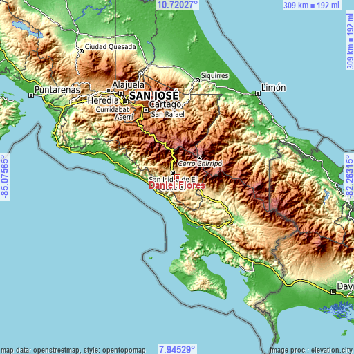
These maps also provides idea of topography and contour of this city, they are displayed at different zoom levels. More info about maps, scale and edge coordinates you can find below images.
| \ | Map #1 | Map #2 | Topo.Map |
| Scale [m] | 545..1006 m | 458..1883 m | × |
| Scale [ft] | 1788..3301 ft | 1503..6178 ft | × |
| Average | 675.9 m = 2218 ft | 803.8 m = 2637 ft | × |
| Width | 9.64 km = 6 mi | 19.29 km = 12 mi | 308.5 km = 191.7 mi |
| Height | 9.64 km = 6 mi | 19.29 km = 12 mi | 308.6 km = 191.8 mi |
| ↑Max Latitude | 9.378901° | 9.422256° | 10.72027° |
| Latitude at center | 9.33554° | 9.33554° | 9.33554° |
| ↓Min Latitude | 9.292174° | 9.248803° | 7.94529° |
| ← Min Longitude | -83.713345° | -83.757291° | -85.07565° |
| Longitude center | -83.6694° | -83.6694° | -83.6694° |
| →Max Longitude | -83.625455° | -83.581509° | -82.26315° |
Nearby cities:
Cities around Daniel Flores sort by population:
• Paraíso elevation 1332 m
59.9 km,  338°
338°
• San Isidro 707 m
4.7 km,  319°
319°
• Buenos Aires 361 m
41 km,  116°
116°
• Quepos 7 m
55.1 km,  281°
281°
• Mercedes 597 m
12.6 km,  130°
130°
• Orosí 1058 m
55.1 km, 338°
• San Marcos 1435 m
52.8 km,  313°
313°
• Ciudad Cortés 10 m
44.7 km,  159°
159°
• Tucurrique 779 m
57.9 km,  354°
354°
• La Suiza 611 m
57.6 km,  5°
5°
• Pejibaye 652 m
53 km,  355°
355°
• San Pablo 1535 m
56.1 km, 313°
Multilingual:
 En español:
Daniel Flores elevación 639 m.
 En France:
Daniel Flores élévation 639 m.
 Auf Deutsch:
Daniel Flores höhe über dem Meeresspiegel ist 639 m.

Sources and notes:
- [note 1] Map square and city borders are not equal. Map elevation data is calculated only from area inside that square.
- [src 1] Elevation data from geonames database provided with same terms of usage.
- [src 2] The elevation map of Daniel Flores is generated using elevation data from NASA's 3 arcsec (90m) resolution SRTM data.
- [src 3] Base (background) map © OpenStreetMap contributors tiles are generated by Geofabrik and OpenTopoMap.
Copyright & License:
This Daniel Flores Elevation Map is licensed under CC BY-SA. You may reuse any part from this page, if you give a proper credit by linking to this URL:
 More info on terms of use page.