Golfito elevation
Golfito (Puntarenas), Costa Rica elevation is 39 meters and Golfito elevation in feet is 128 ft above sea level [src 1]. Golfito is a seat of a second-order administrative division (feature code) with elevation that is 701 meters (2300 ft) smaller than average city elevation in Costa Rica.
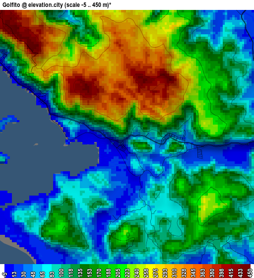
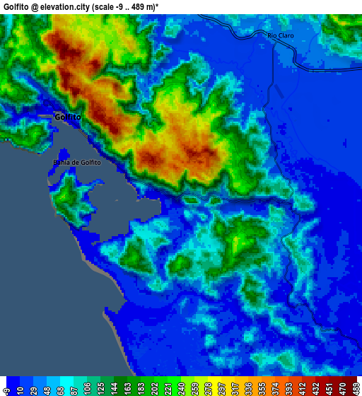
Below is the Elevation map of Golfito, which displays elevation range with different colors. Scale of the first map is from -5 to 450 m (-16 to 1476 ft) with average elevation of 157.4 meters (=516 ft) [note 1]
These maps also provides idea of topography and contour of this city, they are displayed at different zoom levels. More info about maps, scale and edge coordinates you can find below images.
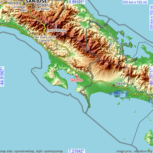
| \ | Map #1 | Map #2 | Topo.Map |
| Scale [m] | -5..450 m | -9..489 m | × |
| Scale [ft] | -16..1476 ft | -30..1604 ft | × |
| Average | 157.4 m = 516 ft | 97 m = 318 ft | × |
| Width | 9.66 km = 6 mi | 19.33 km = 12 mi | 309.2 km = 192.1 mi |
| Height | 9.66 km = 6 mi | 19.33 km = 12 mi | 309.2 km = 192.1 mi |
| ↑Max Latitude | 8.646718° | 8.690162° | 9.99101° |
| Latitude at center | 8.60327° | 8.60327° | 8.60327° |
| ↓Min Latitude | 8.559817° | 8.516358° | 7.21042° |
| ← Min Longitude | -83.157365° | -83.201311° | -84.51967° |
| Longitude center | -83.11342° | -83.11342° | -83.11342° |
| →Max Longitude | -83.069475° | -83.025529° | -81.70717° |
Nearby cities:
Cities around Golfito sort by population:
• San Isidro elevation 707 m
106.4 km,  322°
322°
• Buenos Aires 361 m
67.7 km,  339°
339°
• Daniel Flores 639 m
101.8 km, 323°
• Quepos 7 m
147.4 km,  308°
308°
• Corredor 36 m
18.9 km,  77°
77°
• Mercedes 597 m
89.6 km, 324°
• Canoas 128 m
31.2 km,  104°
104°
• San Vito 994 m
28.8 km,  32°
32°
• Ciudad Cortés 10 m
60 km, 311°
• Sixaola 7 m
116.1 km, 27°
• Pejibaye 652 m
149.1 km,  334°
334°
• Sabalito 897 m
32.8 km,  43°
43°
Multilingual:
 En español:
Golfito elevación 39 m.
 En France:
Golfito élévation 39 m.


Sources and notes:
- [note 1] Map square and city borders are not equal. Map elevation data is calculated only from area inside that square.
- [src 1] Elevation data from geonames database provided with same terms of usage.
- [src 2] The elevation map of Golfito is generated using elevation data from NASA's 3 arcsec (90m) resolution SRTM data.
- [src 3] Base (background) map © OpenStreetMap contributors tiles are generated by Geofabrik and OpenTopoMap.
Copyright & License:
This Golfito Elevation Map is licensed under CC BY-SA. You may reuse any part from this page, if you give a proper credit by linking to this URL:
 More info on terms of use page.