San Vito elevation
San Vito (Puntarenas, Coto Brus), Costa Rica elevation is 994 meters and San Vito elevation in feet is 3261 ft above sea level [src 1]. San Vito is a populated place (feature code) with elevation that is 254 meters (833 ft) bigger than average city elevation in Costa Rica.
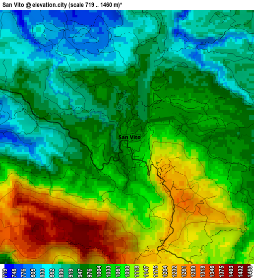
Below is the Elevation map of San Vito, which displays elevation range with different colors. Scale of the first map is from 719 to 1460 m (2359 to 4790 ft) with average elevation of 1017.4 meters (=3338 ft) [note 1]
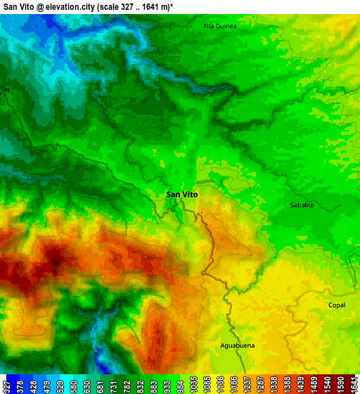
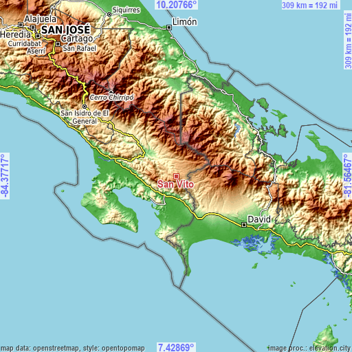
These maps also provides idea of topography and contour of this city, they are displayed at different zoom levels. More info about maps, scale and edge coordinates you can find below images.
| \ | Map #1 | Map #2 | Topo.Map |
| Scale [m] | 719..1460 m | 327..1641 m | × |
| Scale [ft] | 2359..4790 ft | 1073..5384 ft | × |
| Average | 1017.4 m = 3338 ft | 965.3 m = 3167 ft | × |
| Width | 9.66 km = 6 mi | 19.31 km = 12 mi | 309 km = 192 mi |
| Height | 9.66 km = 6 mi | 19.31 km = 12 mi | 309 km = 192 mi |
| ↑Max Latitude | 8.864213° | 8.907631° | 10.20766° |
| Latitude at center | 8.82079° | 8.82079° | 8.82079° |
| ↓Min Latitude | 8.777362° | 8.733929° | 7.42869° |
| ← Min Longitude | -83.014865° | -83.058811° | -84.37717° |
| Longitude center | -82.97092° | -82.97092° | -82.97092° |
| →Max Longitude | -82.926975° | -82.883029° | -81.56467° |
Nearby cities:
Cities around San Vito sort by population:
• Limón elevation 29 m
130.3 km,  356°
356°
• San Isidro 707 m
100.3 km,  307°
307°
• Buenos Aires 361 m
55.8 km, 314°
• Daniel Flores 639 m
95.7 km, 306°
• Corredor 36 m
20.3 km,  172°
172°
• Golfito 39 m
28.8 km,  212°
212°
• Mercedes 597 m
83.2 km, 306°
• Canoas 128 m
35.2 km,  155°
155°
• Ciudad Cortés 10 m
62.7 km,  284°
284°
• La Suiza 611 m
134.7 km,  328°
328°
• Sixaola 7 m
87.4 km,  25°
25°
• Sabalito 897 m
6.8 km,  92°
92°
Multilingual:
 En español:
San Vito elevación 994 m.
 En France:
San Vito élévation 994 m.
 Auf Deutsch:
San Vito höhe über dem Meeresspiegel ist 994 m.

Sources and notes:
- [note 1] Map square and city borders are not equal. Map elevation data is calculated only from area inside that square.
- [src 1] Elevation data from geonames database provided with same terms of usage.
- [src 2] The elevation map of San Vito is generated using elevation data from NASA's 3 arcsec (90m) resolution SRTM data.
- [src 3] Base (background) map © OpenStreetMap contributors tiles are generated by Geofabrik and OpenTopoMap.
Copyright & License:
This San Vito Elevation Map is licensed under CC BY-SA. You may reuse any part from this page, if you give a proper credit by linking to this URL:
 More info on terms of use page.