La Cumbre elevation
La Cumbre (Valle del Cauca, El Cerrito), Colombia elevation is 3342 meters and La Cumbre elevation in feet is 10965 ft above sea level [src 1]. La Cumbre is a populated place (feature code) with elevation that is 2193 meters (7195 ft) bigger than average city elevation in Colombia.
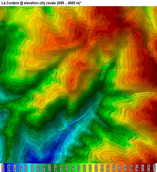
Below is the Elevation map of La Cumbre, which displays elevation range with different colors. Scale of the first map is from 2099 to 4005 m (6886 to 13140 ft) with average elevation of 3146.3 meters (=10323 ft) [note 1]
These maps also provides idea of topography and contour of this city, they are displayed at different zoom levels. More info about maps, scale and edge coordinates you can find below images.
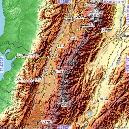
| \ | Map #1 | Topo.Map |
| Scale [m] | 2099..4005 m | × |
| Scale [ft] | 6886..13140 ft | × |
| Average | 3146.3 m = 10323 ft | × |
| Width | 9.75 km = 6.1 mi | 312 km = 193.9 mi |
| Height | 9.75 km = 6.1 mi | 312.1 km = 193.9 mi |
| ↑Max Latitude | 3.766352° | 5.12453° |
| Latitude at center | 3.7225° | 3.7225° |
| ↓Min Latitude | 3.678646° | 2.31824° |
| ← Min Longitude | -76.064775° | -77.42708° |
| Longitude center | -76.02083° | -76.02083° |
| →Max Longitude | -75.976885° | -74.61458° |
Nearby cities:
Cities around La Cumbre sort by population:
• Palmira elevation 1005 m
37.4 km,  237°
237°
• Tuluá 974 m
44.7 km,  334°
334°
• Guadalajara de Buga 979 m
36.6 km,  302°
302°
• Florida 1043 m
50.4 km,  208°
208°
• Pradera 1054 m
41.7 km,  216°
216°
• El Cerrito 990 m
32.8 km,  262°
262°
• Guacarí 976 m
34.9 km,  277°
277°
• Yotoco 956 m
43.1 km,  290°
290°
• Rioblanco 1762 m
46.9 km,  117°
117°
• Ginebra 1036 m
27.3 km,  270°
270°
• San Pedro 988 m
38 km,  322°
322°
• Vijes 973 m
46.8 km, 266°
Multilingual:
 En español:
La Cumbre elevación 3342 m.
 En France:
La Cumbre élévation 3342 m.
 Auf Deutsch:
La Cumbre höhe über dem Meeresspiegel ist 3342 m.

Sources and notes:
- [note 1] Map square and city borders are not equal. Map elevation data is calculated only from area inside that square.
- [src 1] Elevation data from geonames database provided with same terms of usage.
- [src 2] The elevation map of La Cumbre is generated using elevation data from NASA's 3 arcsec (90m) resolution SRTM data.
- [src 3] Base (background) map © OpenStreetMap contributors tiles are generated by Geofabrik and OpenTopoMap.
Copyright & License:
This La Cumbre Elevation Map is licensed under CC BY-SA. You may reuse any part from this page, if you give a proper credit by linking to this URL:
 More info on terms of use page.