Pradera elevation
Pradera (Valle del Cauca), Colombia elevation is 1054 meters and Pradera elevation in feet is 3458 ft above sea level [src 1]. Pradera is a seat of a second-order administrative division (feature code) with elevation that is 95 meters (312 ft) smaller than average city elevation in Colombia.
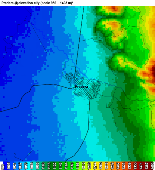
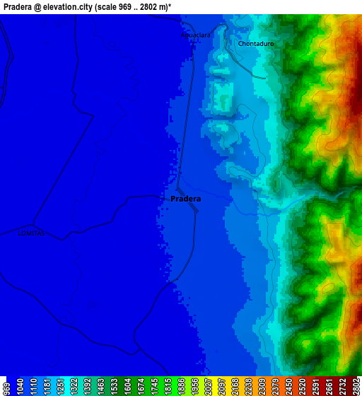
Below is the Elevation map of Pradera, which displays elevation range with different colors. Scale of the first map is from 989 to 1403 m (3245 to 4603 ft) with average elevation of 1075.5 meters (=3529 ft) [note 1]
These maps also provides idea of topography and contour of this city, they are displayed at different zoom levels. More info about maps, scale and edge coordinates you can find below images.
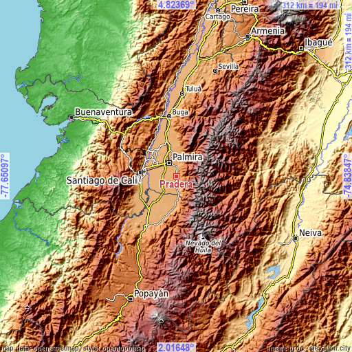
| \ | Map #1 | Map #2 | Topo.Map |
| Scale [m] | 989..1403 m | 969..2802 m | × |
| Scale [ft] | 3245..4603 ft | 3179..9193 ft | × |
| Average | 1075.5 m = 3529 ft | 1231.5 m = 4040 ft | × |
| Width | 9.76 km = 6.1 mi | 19.51 km = 12.1 mi | 312.1 km = 193.9 mi |
| Height | 9.76 km = 6.1 mi | 19.51 km = 12.1 mi | 312.2 km = 194 mi |
| ↑Max Latitude | 3.464976° | 3.50884° | 4.82369° |
| Latitude at center | 3.42111° | 3.42111° | 3.42111° |
| ↓Min Latitude | 3.377242° | 3.333372° | 2.01648° |
| ← Min Longitude | -76.288665° | -76.332611° | -77.65097° |
| Longitude center | -76.24472° | -76.24472° | -76.24472° |
| →Max Longitude | -76.200775° | -76.156829° | -74.83847° |
Nearby cities:
Cities around Pradera sort by population:
• Cali elevation 967 m
30.9 km,  273°
273°
• Palmira 1005 m
14.7 km,  333°
333°
• Yumbo 991 m
32.7 km,  303°
303°
• Puerto Tejada 969 m
28.5 km,  222°
222°
• Florida 1043 m
11 km,  174°
174°
• El Cerrito 990 m
30.4 km,  345°
345°
• Candelaria 977 m
11.6 km,  262°
262°
• Corinto 1059 m
27.7 km,  184°
184°
• Miranda 972 m
18.8 km, 174°
• Ginebra 1036 m
33.8 km,  355°
355°
• Padilla 992 m
23.6 km,  198°
198°
• Guachené 997 m
36 km,  207°
207°
Multilingual:
 En español:
Pradera elevación 1054 m.
 En France:
Pradera élévation 1054 m.
 Auf Deutsch:
Pradera höhe über dem Meeresspiegel ist 1054 m.

Sources and notes:
- [note 1] Map square and city borders are not equal. Map elevation data is calculated only from area inside that square.
- [src 1] Elevation data from geonames database provided with same terms of usage.
- [src 2] The elevation map of Pradera is generated using elevation data from NASA's 3 arcsec (90m) resolution SRTM data.
- [src 3] Base (background) map © OpenStreetMap contributors tiles are generated by Geofabrik and OpenTopoMap.
Copyright & License:
This Pradera Elevation Map is licensed under CC BY-SA. You may reuse any part from this page, if you give a proper credit by linking to this URL:
 More info on terms of use page.