Guacarí elevation
Guacarí (Valle del Cauca), Colombia elevation is 976 meters and Guacarí elevation in feet is 3202 ft above sea level [src 1]. Guacarí is a seat of a second-order administrative division (feature code) with elevation that is 173 meters (568 ft) smaller than average city elevation in Colombia.
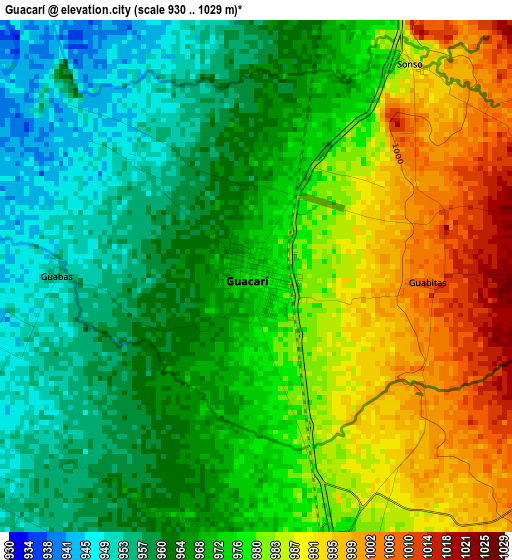
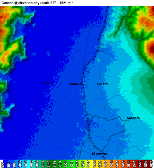
Below is the Elevation map of Guacarí, which displays elevation range with different colors. Scale of the first map is from 930 to 1029 m (3051 to 3376 ft) with average elevation of 973.4 meters (=3194 ft) [note 1]
These maps also provides idea of topography and contour of this city, they are displayed at different zoom levels. More info about maps, scale and edge coordinates you can find below images.
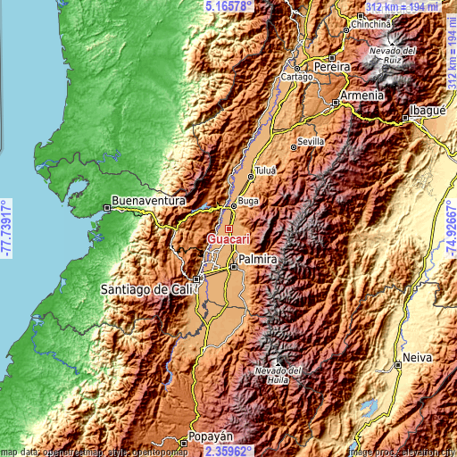
| \ | Map #1 | Map #2 | Topo.Map |
| Scale [m] | 930..1029 m | 927..1621 m | × |
| Scale [ft] | 3051..3376 ft | 3041..5318 ft | × |
| Average | 973.4 m = 3194 ft | 1015.1 m = 3330 ft | × |
| Width | 9.75 km = 6.1 mi | 19.5 km = 12.1 mi | 312 km = 193.9 mi |
| Height | 9.75 km = 6.1 mi | 19.5 km = 12.1 mi | 312 km = 193.9 mi |
| ↑Max Latitude | 3.807679° | 3.851527° | 5.16578° |
| Latitude at center | 3.76383° | 3.76383° | 3.76383° |
| ↓Min Latitude | 3.719978° | 3.676125° | 2.35962° |
| ← Min Longitude | -76.376865° | -76.420811° | -77.73917° |
| Longitude center | -76.33292° | -76.33292° | -76.33292° |
| →Max Longitude | -76.288975° | -76.245029° | -74.92667° |
Nearby cities:
Cities around Guacarí sort by population:
• Palmira elevation 1005 m
25.2 km,  172°
172°
• Guadalajara de Buga 979 m
15.7 km,  14°
14°
• Yumbo 991 m
26.8 km,  221°
221°
• El Cerrito 990 m
9 km, 166°
• Darien 1521 m
25.1 km,  317°
317°
• Restrepo 1406 m
22 km,  287°
287°
• Yotoco 956 m
12.1 km,  332°
332°
• Ginebra 1036 m
8.5 km,  120°
120°
• San Pedro 988 m
28.1 km,  24°
24°
• Vijes 973 m
14.1 km,  239°
239°
• La Cumbre 1561 m
29.2 km, 244°
• Calimita 1542 m
25.1 km,  312°
312°
Multilingual:
 En español:
Guacarí elevación 976 m.
 En France:
Guacarí élévation 976 m.


Sources and notes:
- [note 1] Map square and city borders are not equal. Map elevation data is calculated only from area inside that square.
- [src 1] Elevation data from geonames database provided with same terms of usage.
- [src 2] The elevation map of Guacarí is generated using elevation data from NASA's 3 arcsec (90m) resolution SRTM data.
- [src 3] Base (background) map © OpenStreetMap contributors tiles are generated by Geofabrik and OpenTopoMap.
Copyright & License:
This Guacarí Elevation Map is licensed under CC BY-SA. You may reuse any part from this page, if you give a proper credit by linking to this URL:
 More info on terms of use page.