Restrepo elevation
Restrepo (Valle del Cauca), Colombia elevation is 1406 meters and Restrepo elevation in feet is 4613 ft above sea level [src 1]. Restrepo is a seat of a second-order administrative division (feature code) with elevation that is 257 meters (843 ft) bigger than average city elevation in Colombia.
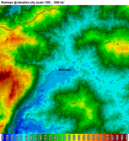
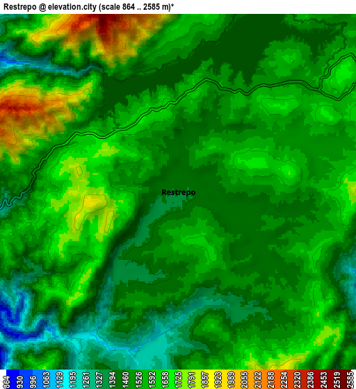
Below is the Elevation map of Restrepo, which displays elevation range with different colors. Scale of the first map is from 1309 to 1906 m (4295 to 6253 ft) with average elevation of 1513.1 meters (=4964 ft) [note 1]
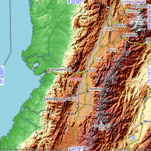
These maps also provides idea of topography and contour of this city, they are displayed at different zoom levels. More info about maps, scale and edge coordinates you can find below images.
| \ | Map #1 | Map #2 | Topo.Map |
| Scale [m] | 1309..1906 m | 864..2585 m | × |
| Scale [ft] | 4295..6253 ft | 2835..8481 ft | × |
| Average | 1513.1 m = 4964 ft | 1531.3 m = 5024 ft | × |
| Width | 9.75 km = 6.1 mi | 19.5 km = 12.1 mi | 312 km = 193.9 mi |
| Height | 9.75 km = 6.1 mi | 19.5 km = 12.1 mi | 312 km = 193.9 mi |
| ↑Max Latitude | 3.865876° | 3.909721° | 5.22387° |
| Latitude at center | 3.82203° | 3.82203° | 3.82203° |
| ↓Min Latitude | 3.778181° | 3.73433° | 2.4179° |
| ← Min Longitude | -76.566365° | -76.610311° | -77.92867° |
| Longitude center | -76.52242° | -76.52242° | -76.52242° |
| →Max Longitude | -76.478475° | -76.434529° | -75.11617° |
Nearby cities:
Cities around Restrepo sort by population:
• Guadalajara de Buga elevation 979 m
26.4 km,  70°
70°
• Yumbo 991 m
26.9 km,  172°
172°
• El Cerrito 990 m
27.7 km,  123°
123°
• Guacarí 976 m
22 km,  107°
107°
• Darien 1521 m
12.9 km,  18°
18°
• Dagua 882 m
26 km,  225°
225°
• Yotoco 956 m
16 km, 74°
• Ginebra 1036 m
30.4 km, 110°
• San Pedro 988 m
37.8 km,  59°
59°
• Vijes 973 m
16.3 km,  146°
146°
• La Cumbre 1561 m
19.8 km,  195°
195°
• Calimita 1542 m
10.8 km,  13°
13°
Multilingual:
 En español:
Restrepo elevación 1406 m.
 En France:
Restrepo élévation 1406 m.
 Auf Deutsch:
Restrepo höhe über dem Meeresspiegel ist 1406 m.

Sources and notes:
- [note 1] Map square and city borders are not equal. Map elevation data is calculated only from area inside that square.
- [src 1] Elevation data from geonames database provided with same terms of usage.
- [src 2] The elevation map of Restrepo is generated using elevation data from NASA's 3 arcsec (90m) resolution SRTM data.
- [src 3] Base (background) map © OpenStreetMap contributors tiles are generated by Geofabrik and OpenTopoMap.
Copyright & License:
This Restrepo Elevation Map is licensed under CC BY-SA. You may reuse any part from this page, if you give a proper credit by linking to this URL:
 More info on terms of use page.