Dagua elevation
Dagua (Valle del Cauca), Colombia elevation is 882 meters and Dagua elevation in feet is 2894 ft above sea level [src 1]. Dagua is a seat of a second-order administrative division (feature code) with elevation that is 267 meters (876 ft) smaller than average city elevation in Colombia.
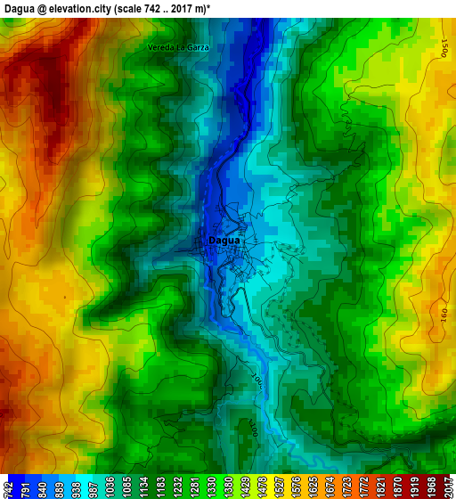
Below is the Elevation map of Dagua, which displays elevation range with different colors. Scale of the first map is from 742 to 2017 m (2434 to 6617 ft) with average elevation of 1293.2 meters (=4243 ft) [note 1]
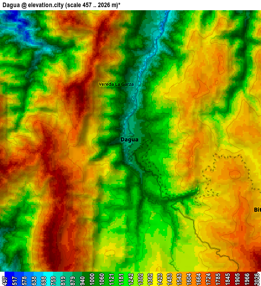
These maps also provides idea of topography and contour of this city, they are displayed at different zoom levels. More info about maps, scale and edge coordinates you can find below images.
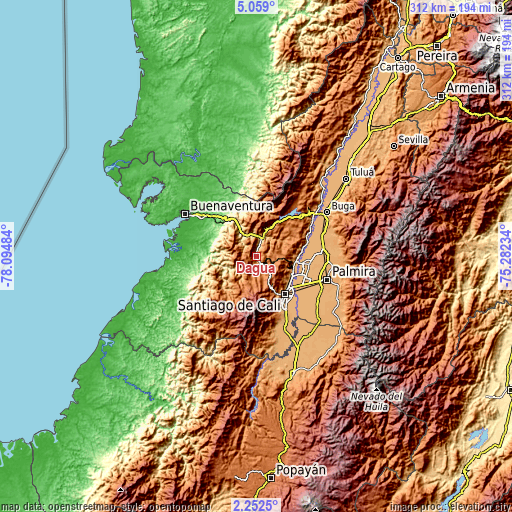
| \ | Map #1 | Map #2 | Topo.Map |
| Scale [m] | 742..2017 m | 457..2026 m | × |
| Scale [ft] | 2434..6617 ft | 1499..6647 ft | × |
| Average | 1293.2 m = 4243 ft | 1351.6 m = 4434 ft | × |
| Width | 9.75 km = 6.1 mi | 19.51 km = 12.1 mi | 312.1 km = 193.9 mi |
| Height | 9.75 km = 6.1 mi | 19.51 km = 12.1 mi | 312.1 km = 193.9 mi |
| ↑Max Latitude | 3.700705° | 3.744557° | 5.059° |
| Latitude at center | 3.65685° | 3.65685° | 3.65685° |
| ↓Min Latitude | 3.612993° | 3.569134° | 2.2525° |
| ← Min Longitude | -76.732535° | -76.776481° | -78.09484° |
| Longitude center | -76.68859° | -76.68859° | -76.68859° |
| →Max Longitude | -76.644645° | -76.600699° | -75.28234° |
Nearby cities:
Cities around Dagua sort by population:
• Cali elevation 967 m
30.6 km,  142°
142°
• Palmira 1005 m
44.7 km,  106°
106°
• Yumbo 991 m
23.4 km, 110°
• El Cerrito 990 m
41.7 km,  85°
85°
• Buenaventura 169 m
35.5 km,  256°
256°
• Guacarí 976 m
41.2 km,  73°
73°
• Darien 1521 m
38 km,  36°
36°
• Restrepo 1406 m
26 km,  45°
45°
• Yotoco 956 m
40.7 km,  56°
56°
• Vijes 973 m
27.7 km,  80°
80°
• Calimita 1542 m
35.7 km, 35°
• La Cumbre 1561 m
13.2 km, 93°
Multilingual:
 En español:
Dagua elevación 882 m.
 En France:
Dagua élévation 882 m.


Sources and notes:
- [note 1] Map square and city borders are not equal. Map elevation data is calculated only from area inside that square.
- [src 1] Elevation data from geonames database provided with same terms of usage.
- [src 2] The elevation map of Dagua is generated using elevation data from NASA's 3 arcsec (90m) resolution SRTM data.
- [src 3] Base (background) map © OpenStreetMap contributors tiles are generated by Geofabrik and OpenTopoMap.
Copyright & License:
This Dagua Elevation Map is licensed under CC BY-SA. You may reuse any part from this page, if you give a proper credit by linking to this URL:
 More info on terms of use page.