Coello elevation
Coello (Tolima, Ibagué), Colombia elevation is 1303 meters and Coello elevation in feet is 4275 ft above sea level [src 1]. Coello is a populated place (feature code) with elevation that is 154 meters (505 ft) bigger than average city elevation in Colombia.
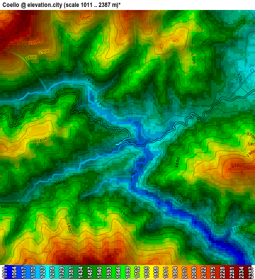
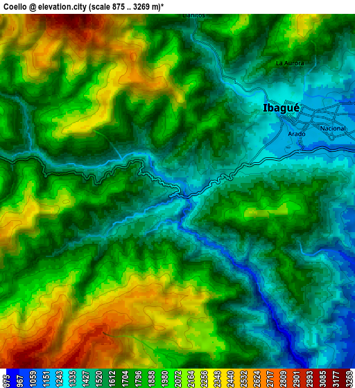
Below is the Elevation map of Coello, which displays elevation range with different colors. Scale of the first map is from 1011 to 2387 m (3317 to 7831 ft) with average elevation of 1590.6 meters (=5219 ft) [note 1]
These maps also provides idea of topography and contour of this city, they are displayed at different zoom levels. More info about maps, scale and edge coordinates you can find below images.
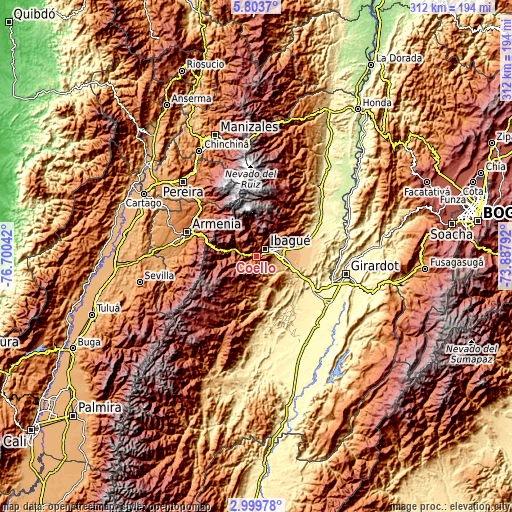
| \ | Map #1 | Map #2 | Topo.Map |
| Scale [m] | 1011..2387 m | 875..3269 m | × |
| Scale [ft] | 3317..7831 ft | 2871..10725 ft | × |
| Average | 1590.6 m = 5219 ft | 1789 m = 5869 ft | × |
| Width | 9.74 km = 6.1 mi | 19.49 km = 12.1 mi | 311.8 km = 193.7 mi |
| Height | 9.74 km = 6.1 mi | 19.49 km = 12.1 mi | 311.8 km = 193.7 mi |
| ↑Max Latitude | 4.446874° | 4.490686° | 5.8037° |
| Latitude at center | 4.40306° | 4.40306° | 4.40306° |
| ↓Min Latitude | 4.359243° | 4.315424° | 2.99978° |
| ← Min Longitude | -75.338115° | -75.382061° | -76.70042° |
| Longitude center | -75.29417° | -75.29417° | -75.29417° |
| →Max Longitude | -75.250225° | -75.206279° | -73.88792° |
Nearby cities:
Cities around Coello sort by population:
• Ibagué elevation 1229 m
7.9 km,  59°
59°
• Payandé 700 m
24.8 km,  118°
118°
• Anaime 1818 m
16.7 km,  267°
267°
• Chicoral 409 m
40.4 km, 121°
• Cajamarca 1818 m
15.5 km,  286°
286°
• Rovira 867 m
19.2 km,  161°
161°
• San Luis 478 m
37.3 km,  143°
143°
• Salento 1995 m
40.2 km,  310°
310°
• Doima 603 m
35.4 km,  85°
85°
• Anzoátegui 1767 m
33.6 km,  41°
41°
• Laureles 1724 m
16.3 km,  191°
191°
• Valle de San Juan 588 m
30 km, 139°
Multilingual:
 En español:
Coello elevación 1303 m.
 En France:
Coello élévation 1303 m.


Sources and notes:
- [note 1] Map square and city borders are not equal. Map elevation data is calculated only from area inside that square.
- [src 1] Elevation data from geonames database provided with same terms of usage.
- [src 2] The elevation map of Coello is generated using elevation data from NASA's 3 arcsec (90m) resolution SRTM data.
- [src 3] Base (background) map © OpenStreetMap contributors tiles are generated by Geofabrik and OpenTopoMap.
Copyright & License:
This Coello Elevation Map is licensed under CC BY-SA. You may reuse any part from this page, if you give a proper credit by linking to this URL:
 More info on terms of use page.