Cúcuta elevation
Cúcuta (Norte de Santander), Colombia elevation is 309 meters and Cúcuta elevation in feet is 1014 ft above sea level [src 1]. Cúcuta is a seat of a first-order administrative division (feature code) with elevation that is 840 meters (2756 ft) smaller than average city elevation in Colombia.
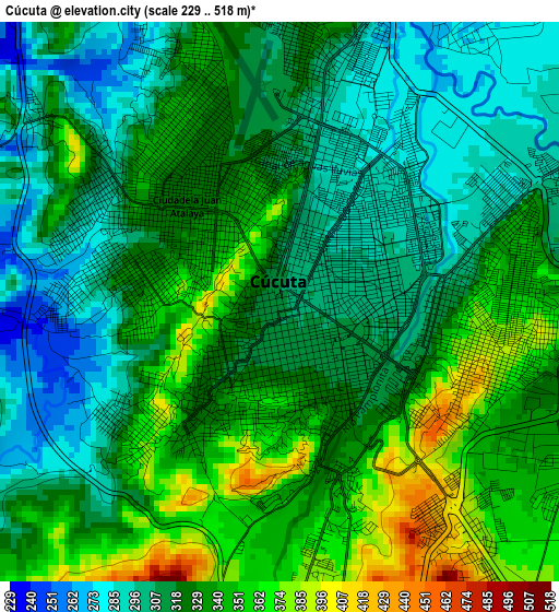
Below is the Elevation map of Cúcuta, which displays elevation range with different colors. Scale of the first map is from 229 to 518 m (751 to 1699 ft) with average elevation of 324.9 meters (=1066 ft) [note 1]
These maps also provides idea of topography and contour of this city, they are displayed at different zoom levels. More info about maps, scale and edge coordinates you can find below images.
| \ | Map #1 | Map #2 | Topo.Map |
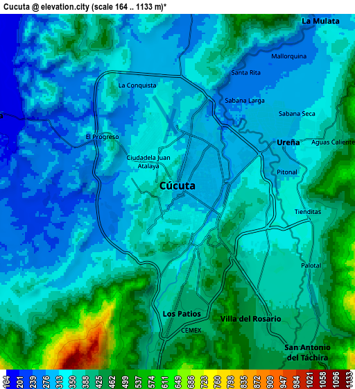
| Scale [m] | 229..518 m | 164..1133 m | × |
| Scale [ft] | 751..1699 ft | 538..3717 ft | × |
| Average | 324.9 m = 1066 ft | 362.9 m = 1191 ft | × |
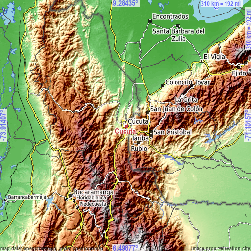
| Width | 9.68 km = 6 mi | 19.36 km = 12 mi | 309.7 km = 192.4 mi |
| Height | 9.68 km = 6 mi | 19.36 km = 12 mi | 309.8 km = 192.5 mi |
| ↑Max Latitude | 7.937437° | 7.980959° | 9.28435° |
| Latitude at center | 7.89391° | 7.89391° | 7.89391° |
| ↓Min Latitude | 7.850379° | 7.806843° | 6.49877° |
| ← Min Longitude | -72.551765° | -72.595711° | -73.91407° |
| Longitude center | -72.50782° | -72.50782° | -72.50782° |
| →Max Longitude | -72.463875° | -72.419929° | -71.10157° |
Nearby cities:
Cities around Cúcuta sort by population:
• Villa del Rosario elevation 436 m
7.6 km,  150°
150°
• Los Patios 395 m
6.2 km,  175°
175°
• El Zulia 207 m
11.1 km,  292°
292°
• Chinácota 1232 m
33.5 km,  197°
197°
• Gramalote 1038 m
31.9 km,  268°
268°
• Ragonvalia 1546 m
35.4 km,  174°
174°
• Durania 961 m
26 km,  219°
219°
• La Esperanza 81 m
35.5 km,  7°
7°
• Bochalema 1069 m
35 km,  206°
206°
• Lourdes 1426 m
36.2 km,  278°
278°
• San Cayetano 240 m
13 km,  261°
261°
• Santiago 435 m
23.2 km, 261°
Multilingual:
 En español:
Cúcuta elevación 309 m.
 En France:
Cúcuta élévation 309 m.


Sources and notes:
- [note 1] Map square and city borders are not equal. Map elevation data is calculated only from area inside that square.
- [src 1] Elevation data from geonames database provided with same terms of usage.
- [src 2] The elevation map of Cúcuta is generated using elevation data from NASA's 3 arcsec (90m) resolution SRTM data.
- [src 3] Base (background) map © OpenStreetMap contributors tiles are generated by Geofabrik and OpenTopoMap.
Copyright & License:
This Cúcuta Elevation Map is licensed under CC BY-SA. You may reuse any part from this page, if you give a proper credit by linking to this URL:
 More info on terms of use page.