Chinácota elevation
Chinácota (Norte de Santander), Colombia elevation is 1232 meters and Chinácota elevation in feet is 4042 ft above sea level [src 1]. Chinácota is a seat of a second-order administrative division (feature code) with elevation that is 83 meters (272 ft) bigger than average city elevation in Colombia.
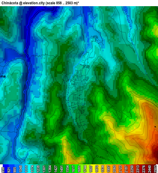
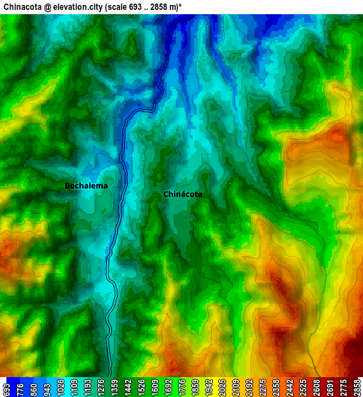
Below is the Elevation map of Chinácota, which displays elevation range with different colors. Scale of the first map is from 858 to 2503 m (2815 to 8212 ft) with average elevation of 1336.5 meters (=4385 ft) [note 1]
These maps also provides idea of topography and contour of this city, they are displayed at different zoom levels. More info about maps, scale and edge coordinates you can find below images.
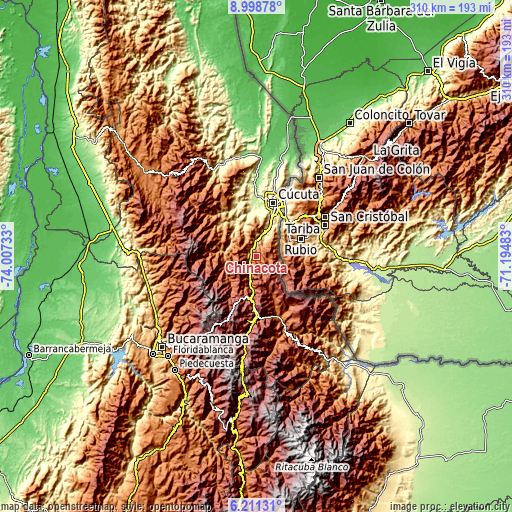
| \ | Map #1 | Map #2 | Topo.Map |
| Scale [m] | 858..2503 m | 693..2858 m | × |
| Scale [ft] | 2815..8212 ft | 2274..9377 ft | × |
| Average | 1336.5 m = 4385 ft | 1552.6 m = 5094 ft | × |
| Width | 9.69 km = 6 mi | 19.37 km = 12 mi | 309.9 km = 192.6 mi |
| Height | 9.69 km = 6 mi | 19.37 km = 12 mi | 310 km = 192.6 mi |
| ↑Max Latitude | 7.650866° | 7.694418° | 8.99878° |
| Latitude at center | 7.60731° | 7.60731° | 7.60731° |
| ↓Min Latitude | 7.563749° | 7.520184° | 6.21131° |
| ← Min Longitude | -72.645025° | -72.688971° | -74.00733° |
| Longitude center | -72.60108° | -72.60108° | -72.60108° |
| →Max Longitude | -72.557135° | -72.513189° | -71.19483° |
Nearby cities:
Cities around Chinácota sort by population:
• Villa del Rosario elevation 436 m
28.8 km,  29°
29°
• Los Patios 395 m
27.8 km,  22°
22°
• Pamplona 2294 m
26.3 km,  191°
191°
• Ragonvalia 1546 m
14.2 km,  103°
103°
• Durania 961 m
13.3 km,  332°
332°
• Arboledas 940 m
22.2 km,  280°
280°
• Bochalema 1069 m
5.2 km,  274°
274°
• Cucutilla 1281 m
20.3 km,  248°
248°
• Herrán 1960 m
17.2 km,  130°
130°
• San Cayetano 240 m
30.1 km,  355°
355°
• Santiago 435 m
31.3 km,  336°
336°
• Pamplonita 1733 m
19.4 km, 192°
Multilingual:
 En español:
Chinácota elevación 1232 m.
 En France:
Chinácota élévation 1232 m.
 Auf Deutsch:
Chinácota höhe über dem Meeresspiegel ist 1232 m.

Sources and notes:
- [note 1] Map square and city borders are not equal. Map elevation data is calculated only from area inside that square.
- [src 1] Elevation data from geonames database provided with same terms of usage.
- [src 2] The elevation map of Chinácota is generated using elevation data from NASA's 3 arcsec (90m) resolution SRTM data.
- [src 3] Base (background) map © OpenStreetMap contributors tiles are generated by Geofabrik and OpenTopoMap.
Copyright & License:
This Chinácota Elevation Map is licensed under CC BY-SA. You may reuse any part from this page, if you give a proper credit by linking to this URL:
 More info on terms of use page.