Gramalote elevation
Gramalote (Norte de Santander), Colombia elevation is 1038 meters and Gramalote elevation in feet is 3406 ft above sea level [src 1]. Gramalote is a seat of a second-order administrative division (feature code) with elevation that is 111 meters (364 ft) smaller than average city elevation in Colombia.
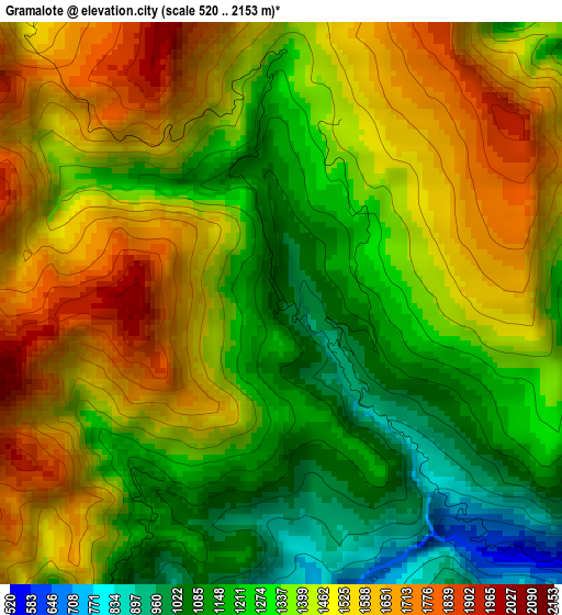
Below is the Elevation map of Gramalote, which displays elevation range with different colors. Scale of the first map is from 520 to 2153 m (1706 to 7064 ft) with average elevation of 1385.4 meters (=4545 ft) [note 1]
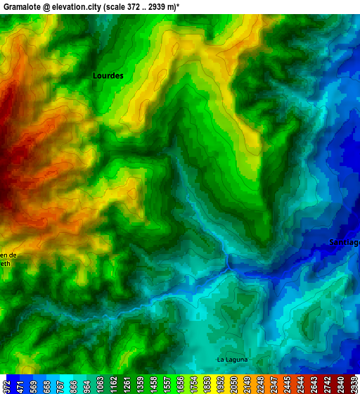
These maps also provides idea of topography and contour of this city, they are displayed at different zoom levels. More info about maps, scale and edge coordinates you can find below images.
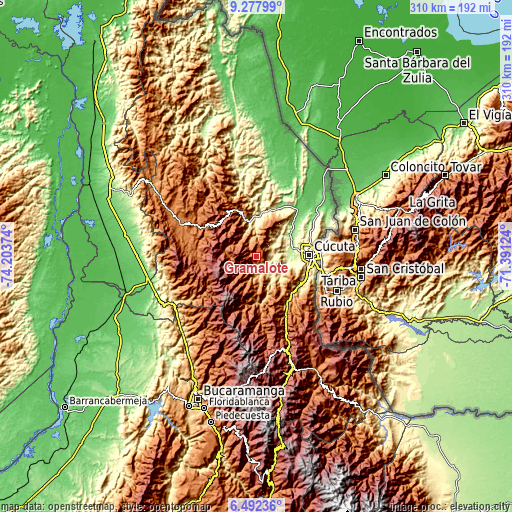
| \ | Map #1 | Map #2 | Topo.Map |
| Scale [m] | 520..2153 m | 372..2939 m | × |
| Scale [ft] | 1706..7064 ft | 1220..9642 ft | × |
| Average | 1385.4 m = 4545 ft | 1343.6 m = 4408 ft | × |
| Width | 9.68 km = 6 mi | 19.36 km = 12 mi | 309.7 km = 192.4 mi |
| Height | 9.68 km = 6 mi | 19.36 km = 12 mi | 309.8 km = 192.5 mi |
| ↑Max Latitude | 7.931047° | 7.97457° | 9.27799° |
| Latitude at center | 7.88752° | 7.88752° | 7.88752° |
| ↓Min Latitude | 7.843988° | 7.800452° | 6.49236° |
| ← Min Longitude | -72.841435° | -72.885381° | -74.20374° |
| Longitude center | -72.79749° | -72.79749° | -72.79749° |
| →Max Longitude | -72.753545° | -72.709599° | -71.39124° |
Nearby cities:
Cities around Gramalote sort by population:
• Cúcuta elevation 309 m
31.9 km,  88°
88°
• Los Patios 395 m
32.8 km,  99°
99°
• El Zulia 207 m
22.2 km,  76°
76°
• Sardinata 309 m
21.7 km,  359°
359°
• Durania 961 m
24.8 km,  141°
141°
• Arboledas 940 m
27.3 km,  180°
180°
• Cáchira 2007 m
32.1 km,  239°
239°
• Lourdes 1426 m
7.4 km,  328°
328°
• San Cayetano 240 m
19.1 km, 93°
• Santiago 435 m
9.3 km,  106°
106°
• Bucarasica 1167 m
18.6 km,  336°
336°
• Villa Caro 1595 m
19.4 km,  278°
278°
Multilingual:
 En español:
Gramalote elevación 1038 m.
 En France:
Gramalote élévation 1038 m.
 Auf Deutsch:
Gramalote höhe über dem Meeresspiegel ist 1038 m.

Sources and notes:
- [note 1] Map square and city borders are not equal. Map elevation data is calculated only from area inside that square.
- [src 1] Elevation data from geonames database provided with same terms of usage.
- [src 2] The elevation map of Gramalote is generated using elevation data from NASA's 3 arcsec (90m) resolution SRTM data.
- [src 3] Base (background) map © OpenStreetMap contributors tiles are generated by Geofabrik and OpenTopoMap.
Copyright & License:
This Gramalote Elevation Map is licensed under CC BY-SA. You may reuse any part from this page, if you give a proper credit by linking to this URL:
 More info on terms of use page.