Municipio Hato Corozal elevation
Municipio Hato Corozal (Casanare, Hato Corozal), Colombia elevation is 256 meters and Municipio Hato Corozal elevation in feet is 840 ft above sea level [src 1]. Municipio Hato Corozal is a populated place (feature code) with elevation that is 893 meters (2930 ft) smaller than average city elevation in Colombia.
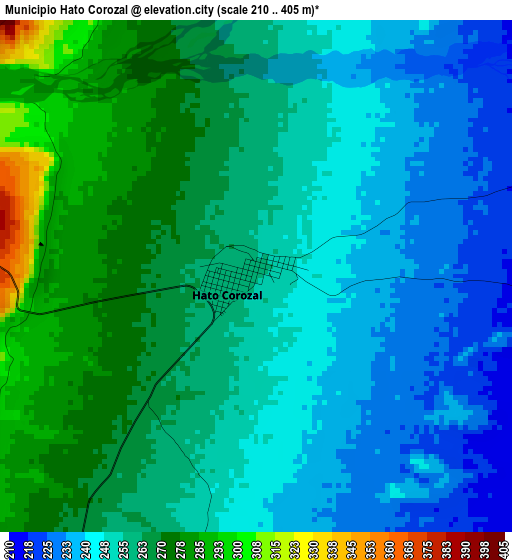
Below is the Elevation map of Municipio Hato Corozal, which displays elevation range with different colors. Scale of the first map is from 210 to 405 m (689 to 1329 ft) with average elevation of 255.9 meters (=840 ft) [note 1]
These maps also provides idea of topography and contour of this city, they are displayed at different zoom levels. More info about maps, scale and edge coordinates you can find below images.
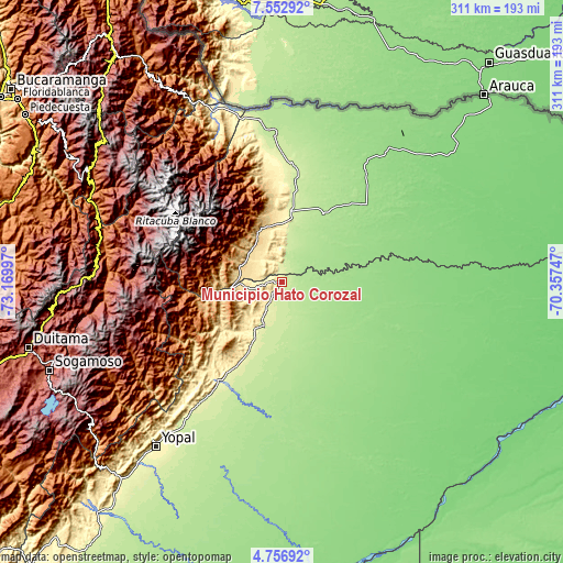
| \ | Map #1 | Topo.Map |
| Scale [m] | 210..405 m | × |
| Scale [ft] | 689..1329 ft | × |
| Average | 255.9 m = 840 ft | × |
| Width | 9.72 km = 6 mi | 310.9 km = 193.2 mi |
| Height | 9.72 km = 6 mi | 310.9 km = 193.2 mi |
| ↑Max Latitude | 6.20045° | 7.55292° |
| Latitude at center | 6.15676° | 6.15676° |
| ↓Min Latitude | 6.113066° | 4.75692° |
| ← Min Longitude | -71.807665° | -73.16997° |
| Longitude center | -71.76372° | -71.76372° |
| →Max Longitude | -71.719775° | -70.35747° |
Nearby cities:
Cities around Municipio Hato Corozal sort by population:
• Tame elevation 320 m
33.9 km,  5°
5°
• Fortul 241 m
70.7 km,  358°
358°
• Pore 287 m
54 km,  207°
207°
• Puerto Rondón 137 m
74.6 km,  79°
79°
• Chita 2934 m
78.8 km,  272°
272°
• El Cocuy 2646 m
80.8 km,  290°
290°
• Güicán 2820 m
79.8 km,  295°
295°
• Támara 1120 m
57.2 km,  230°
230°
• Nunchía 396 m
75.1 km,  219°
219°
• Sácama 1248 m
54 km,  263°
263°
• La Salina 1729 m
63.6 km, 267°
• Paz de Ariporo 271 m
33.7 km,  204°
204°
Multilingual:
 En español:
Municipio Hato Corozal elevación 256 m.
 En France:
Municipio Hato Corozal élévation 256 m.
 Auf Deutsch:
Municipio Hato Corozal höhe über dem Meeresspiegel ist 256 m.
 На русском:
Municipio Hato Corozal высота над уровнем моря 256 м
Sources and notes:
- [note 1] Map square and city borders are not equal. Map elevation data is calculated only from area inside that square.
- [src 1] Elevation data from geonames database provided with same terms of usage.
- [src 2] The elevation map of Municipio Hato Corozal is generated using elevation data from NASA's 3 arcsec (90m) resolution SRTM data.
- [src 3] Base (background) map © OpenStreetMap contributors tiles are generated by Geofabrik and OpenTopoMap.
Copyright & License:
This Municipio Hato Corozal Elevation Map is licensed under CC BY-SA. You may reuse any part from this page, if you give a proper credit by linking to this URL:
 More info on terms of use page.