Sácama elevation
Sácama (Casanare), Colombia elevation is 1248 meters and Sácama elevation in feet is 4094 ft above sea level [src 1]. Sácama is a seat of a second-order administrative division (feature code) with elevation that is 99 meters (325 ft) bigger than average city elevation in Colombia.
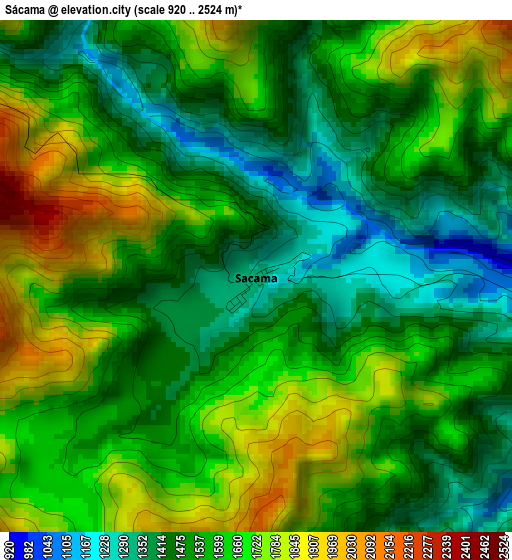
Below is the Elevation map of Sácama, which displays elevation range with different colors. Scale of the first map is from 920 to 2524 m (3018 to 8281 ft) with average elevation of 1579 meters (=5180 ft) [note 1]
These maps also provides idea of topography and contour of this city, they are displayed at different zoom levels. More info about maps, scale and edge coordinates you can find below images.
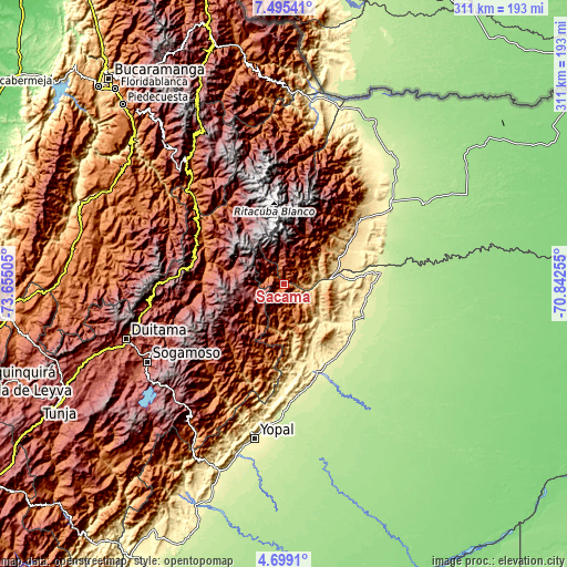
| \ | Map #1 | Topo.Map |
| Scale [m] | 920..2524 m | × |
| Scale [ft] | 3018..8281 ft | × |
| Average | 1579 m = 5180 ft | × |
| Width | 9.72 km = 6 mi | 310.9 km = 193.2 mi |
| Height | 9.72 km = 6 mi | 311 km = 193.2 mi |
| ↑Max Latitude | 6.142775° | 7.49541° |
| Latitude at center | 6.09908° | 6.09908° |
| ↓Min Latitude | 6.055382° | 4.6991° |
| ← Min Longitude | -72.292745° | -73.65505° |
| Longitude center | -72.2488° | -72.2488° |
| →Max Longitude | -72.204855° | -70.84255° |
Nearby cities:
Cities around Sácama sort by population:
• Boavita elevation 2167 m
45.2 km,  304°
304°
• Chita 2934 m
27.1 km,  292°
292°
• El Cocuy 2646 m
41.2 km,  327°
327°
• Socotá 2413 m
43.2 km,  261°
261°
• Güicán 2820 m
44.7 km,  335°
335°
• Támara 1120 m
31.4 km,  162°
162°
• La Uvita 2350 m
42.6 km,  305°
305°
• San Mateo 2223 m
47.6 km,  315°
315°
• Jericó 3075 m
36 km,  278°
278°
• Panqueba 2196 m
45.2 km, 328°
• Paz de Ariporo 271 m
46.3 km,  121°
121°
• La Salina 1729 m
10.5 km, 290°
Multilingual:
 En español:
Sácama elevación 1248 m.
 En France:
Sácama élévation 1248 m.


Sources and notes:
- [note 1] Map square and city borders are not equal. Map elevation data is calculated only from area inside that square.
- [src 1] Elevation data from geonames database provided with same terms of usage.
- [src 2] The elevation map of Sácama is generated using elevation data from NASA's 3 arcsec (90m) resolution SRTM data.
- [src 3] Base (background) map © OpenStreetMap contributors tiles are generated by Geofabrik and OpenTopoMap.
Copyright & License:
This Sácama Elevation Map is licensed under CC BY-SA. You may reuse any part from this page, if you give a proper credit by linking to this URL:
 More info on terms of use page.