Panqueba elevation
Panqueba (Boyacá), Colombia elevation is 2196 meters and Panqueba elevation in feet is 7205 ft above sea level [src 1]. Panqueba is a seat of a second-order administrative division (feature code) with elevation that is 1047 meters (3435 ft) bigger than average city elevation in Colombia.
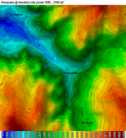
Below is the Elevation map of Panqueba, which displays elevation range with different colors. Scale of the first map is from 1859 to 3700 m (6099 to 12139 ft) with average elevation of 2762.9 meters (=9065 ft) [note 1]
These maps also provides idea of topography and contour of this city, they are displayed at different zoom levels. More info about maps, scale and edge coordinates you can find below images.
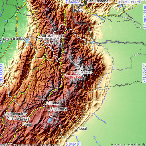
| \ | Map #1 | Topo.Map |
| Scale [m] | 1859..3700 m | × |
| Scale [ft] | 6099..12139 ft | × |
| Average | 2762.9 m = 9065 ft | × |
| Width | 9.71 km = 6 mi | 310.7 km = 193.1 mi |
| Height | 9.71 km = 6 mi | 310.7 km = 193.1 mi |
| ↑Max Latitude | 6.488996° | 7.84063° |
| Latitude at center | 6.44533° | 6.44533° |
| ↓Min Latitude | 6.401661° | 5.04618° |
| ← Min Longitude | -72.506625° | -73.86893° |
| Longitude center | -72.46268° | -72.46268° |
| →Max Longitude | -72.418735° | -71.05643° |
Nearby cities:
Cities around Panqueba sort by population:
• Boavita elevation 2167 m
18.6 km,  226°
226°
• El Cocuy 2646 m
4.1 km,  157°
157°
• Güicán 2820 m
5.7 km,  66°
66°
• La Uvita 2350 m
17.7 km,  218°
218°
• San Mateo 2223 m
11.1 km,  244°
244°
• Chiscas 2404 m
13.2 km,  339°
339°
• El Espino 2127 m
5.6 km,  317°
317°
• Tipacoque 1878 m
25.5 km,  263°
263°
• Carcasí 2107 m
27.1 km, 318°
• Guacamayas 2151 m
5 km,  292°
292°
• San Miguel 1926 m
24.9 km,  305°
305°
• Macaravita 2291 m
15.9 km, 294°
Multilingual:
 En español:
Panqueba elevación 2196 m.
 En France:
Panqueba élévation 2196 m.
 Auf Deutsch:
Panqueba höhe über dem Meeresspiegel ist 2196 m.

Sources and notes:
- [note 1] Map square and city borders are not equal. Map elevation data is calculated only from area inside that square.
- [src 1] Elevation data from geonames database provided with same terms of usage.
- [src 2] The elevation map of Panqueba is generated using elevation data from NASA's 3 arcsec (90m) resolution SRTM data.
- [src 3] Base (background) map © OpenStreetMap contributors tiles are generated by Geofabrik and OpenTopoMap.
Copyright & License:
This Panqueba Elevation Map is licensed under CC BY-SA. You may reuse any part from this page, if you give a proper credit by linking to this URL:
 More info on terms of use page.