Santuario elevation
Santuario (Antioquia, El Santuario), Colombia elevation is 2119 meters and Santuario elevation in feet is 6952 ft above sea level [src 1]. Santuario is a seat of a second-order administrative division (feature code) with elevation that is 970 meters (3182 ft) bigger than average city elevation in Colombia.
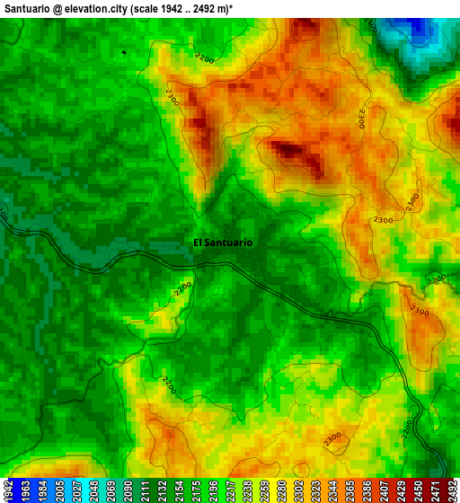
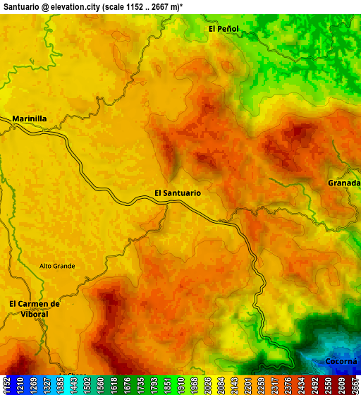
Below is the Elevation map of Santuario, which displays elevation range with different colors. Scale of the first map is from 1942 to 2492 m (6371 to 8176 ft) with average elevation of 2210.3 meters (=7252 ft) [note 1]
These maps also provides idea of topography and contour of this city, they are displayed at different zoom levels. More info about maps, scale and edge coordinates you can find below images.
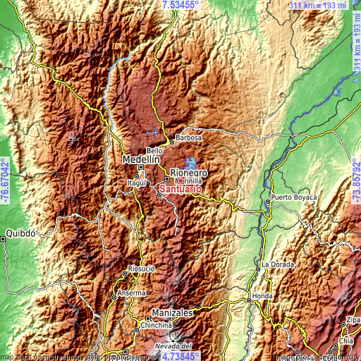
| \ | Map #1 | Map #2 | Topo.Map |
| Scale [m] | 1942..2492 m | 1152..2667 m | × |
| Scale [ft] | 6371..8176 ft | 3780..8750 ft | × |
| Average | 2210.3 m = 7252 ft | 2137.7 m = 7013 ft | × |
| Width | 9.72 km = 6 mi | 19.43 km = 12.1 mi | 310.9 km = 193.2 mi |
| Height | 9.72 km = 6 mi | 19.43 km = 12.1 mi | 310.9 km = 193.2 mi |
| ↑Max Latitude | 6.182022° | 6.22571° | 7.53455° |
| Latitude at center | 6.13833° | 6.13833° | 6.13833° |
| ↓Min Latitude | 6.094635° | 6.050936° | 4.73845° |
| ← Min Longitude | -75.308115° | -75.352061° | -76.67042° |
| Longitude center | -75.26417° | -75.26417° | -75.26417° |
| →Max Longitude | -75.220225° | -75.176279° | -73.85792° |
Nearby cities:
Cities around Santuario sort by population:
• Rionegro elevation 2090 m
12.3 km,  278°
278°
• La Ceja 2153 m
22.2 km,  237°
237°
• Marinilla 2085 m
8.9 km,  296°
296°
• Carmen de Viboral 2153 m
10 km,  231°
231°
• Guarne 2141 m
25.4 km,  308°
308°
• La Unión 2475 m
21.2 km,  210°
210°
• Retiro 2166 m
27.9 km,  251°
251°
• Granada 2081 m
8.7 km,  86°
86°
• Guatapé 1889 m
15.4 km,  46°
46°
• Cocorná 1304 m
12.5 km,  135°
135°
• San Vicente 2184 m
18.1 km,  334°
334°
• San Francisco 1276 m
26.4 km, 137°
Multilingual:
 En español:
Santuario elevación 2119 m.
 En France:
Santuario élévation 2119 m.
 Auf Deutsch:
Santuario höhe über dem Meeresspiegel ist 2119 m.

Sources and notes:
- [note 1] Map square and city borders are not equal. Map elevation data is calculated only from area inside that square.
- [src 1] Elevation data from geonames database provided with same terms of usage.
- [src 2] The elevation map of Santuario is generated using elevation data from NASA's 3 arcsec (90m) resolution SRTM data.
- [src 3] Base (background) map © OpenStreetMap contributors tiles are generated by Geofabrik and OpenTopoMap.
Copyright & License:
This Santuario Elevation Map is licensed under CC BY-SA. You may reuse any part from this page, if you give a proper credit by linking to this URL:
 More info on terms of use page.