San Vicente elevation
San Vicente (Antioquia, San Vicente Ferrer), Colombia elevation is 2184 meters and San Vicente elevation in feet is 7165 ft above sea level [src 1]. San Vicente is a seat of a second-order administrative division (feature code) with elevation that is 1035 meters (3396 ft) bigger than average city elevation in Colombia.
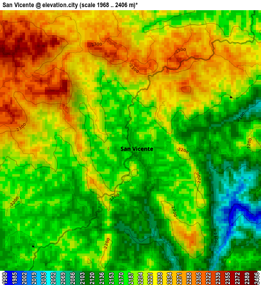
Below is the Elevation map of San Vicente, which displays elevation range with different colors. Scale of the first map is from 1968 to 2406 m (6457 to 7894 ft) with average elevation of 2198.4 meters (=7213 ft) [note 1]
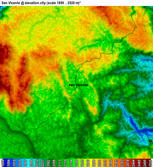
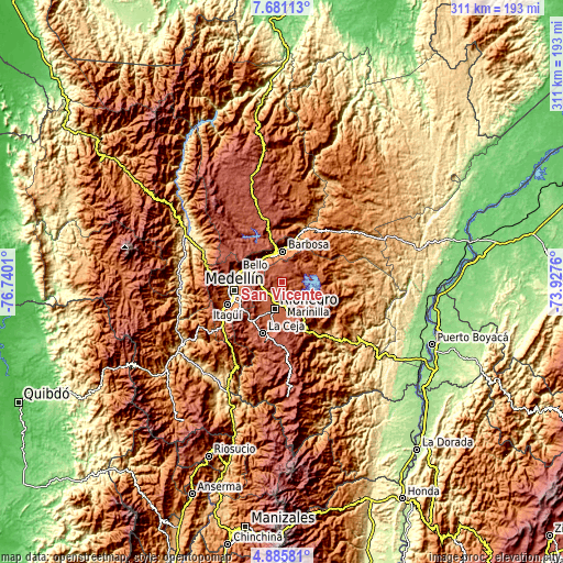
These maps also provides idea of topography and contour of this city, they are displayed at different zoom levels. More info about maps, scale and edge coordinates you can find below images.
| \ | Map #1 | Map #2 | Topo.Map |
| Scale [m] | 1968..2406 m | 1859..2520 m | × |
| Scale [ft] | 6457..7894 ft | 6099..8268 ft | × |
| Average | 2198.4 m = 7213 ft | 2192.4 m = 7193 ft | × |
| Width | 9.71 km = 6 mi | 19.43 km = 12.1 mi | 310.8 km = 193.1 mi |
| Height | 9.71 km = 6 mi | 19.43 km = 12.1 mi | 310.8 km = 193.1 mi |
| ↑Max Latitude | 6.329029° | 6.372705° | 7.68113° |
| Latitude at center | 6.28535° | 6.28535° | 6.28535° |
| ↓Min Latitude | 6.241667° | 6.19798° | 4.88581° |
| ← Min Longitude | -75.377795° | -75.421741° | -76.7401° |
| Longitude center | -75.33385° | -75.33385° | -75.33385° |
| →Max Longitude | -75.289905° | -75.245959° | -73.9276° |
Nearby cities:
Cities around San Vicente sort by population:
• Rionegro elevation 2090 m
15.1 km,  196°
196°
• Copacabana 1411 m
20.5 km,  289°
289°
• Marinilla 2085 m
12.4 km,  181°
181°
• Carmen de Viboral 2153 m
22.6 km, 180°
• Santuario 2119 m
18.1 km,  154°
154°
• Barbosa 1297 m
17 km,  0°
0°
• Guarne 2141 m
12.1 km,  267°
267°
• Donmatías 2157 m
23.3 km,  343°
343°
• Granada 2081 m
22.8 km,  133°
133°
• Guatapé 1889 m
19.7 km,  106°
106°
• Concepción 1832 m
14.7 km,  34°
34°
• Girardota 1427 m
16.3 km,  308°
308°
Multilingual:
 En español:
San Vicente elevación 2184 m.
 En France:
San Vicente élévation 2184 m.
 Auf Deutsch:
San Vicente höhe über dem Meeresspiegel ist 2184 m.

Sources and notes:
- [note 1] Map square and city borders are not equal. Map elevation data is calculated only from area inside that square.
- [src 1] Elevation data from geonames database provided with same terms of usage.
- [src 2] The elevation map of San Vicente is generated using elevation data from NASA's 3 arcsec (90m) resolution SRTM data.
- [src 3] Base (background) map © OpenStreetMap contributors tiles are generated by Geofabrik and OpenTopoMap.
Copyright & License:
This San Vicente Elevation Map is licensed under CC BY-SA. You may reuse any part from this page, if you give a proper credit by linking to this URL:
 More info on terms of use page.