La Ceja elevation
La Ceja (Antioquia), Colombia elevation is 2153 meters and La Ceja elevation in feet is 7064 ft above sea level [src 1]. La Ceja is a seat of a second-order administrative division (feature code) with elevation that is 1004 meters (3294 ft) bigger than average city elevation in Colombia.
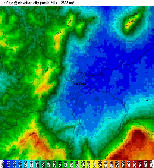
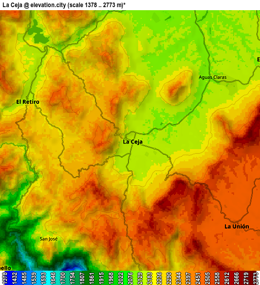
Below is the Elevation map of La Ceja, which displays elevation range with different colors. Scale of the first map is from 2114 to 2698 m (6936 to 8852 ft) with average elevation of 2279.4 meters (=7478 ft) [note 1]
These maps also provides idea of topography and contour of this city, they are displayed at different zoom levels. More info about maps, scale and edge coordinates you can find below images.
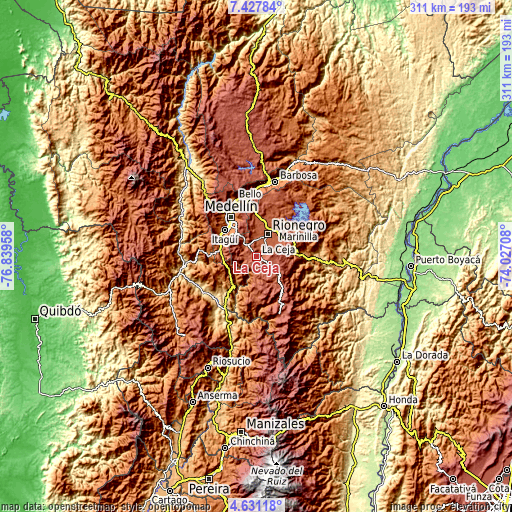
| \ | Map #1 | Map #2 | Topo.Map |
| Scale [m] | 2114..2698 m | 1378..2773 m | × |
| Scale [ft] | 6936..8852 ft | 4521..9098 ft | × |
| Average | 2279.4 m = 7478 ft | 2275.9 m = 7467 ft | × |
| Width | 9.72 km = 6 mi | 19.44 km = 12.1 mi | 311 km = 193.2 mi |
| Height | 9.72 km = 6 mi | 19.44 km = 12.1 mi | 311 km = 193.2 mi |
| ↑Max Latitude | 6.07501° | 6.118707° | 7.42784° |
| Latitude at center | 6.03131° | 6.03131° | 6.03131° |
| ↓Min Latitude | 5.987606° | 5.943899° | 4.63118° |
| ← Min Longitude | -75.477275° | -75.521221° | -76.83958° |
| Longitude center | -75.43333° | -75.43333° | -75.43333° |
| →Max Longitude | -75.389385° | -75.345439° | -74.02708° |
Nearby cities:
Cities around La Ceja sort by population:
• Itagüí elevation 1538 m
25 km,  312°
312°
• Envigado 1539 m
23.8 km, 312°
• Caldas 1756 m
23.3 km,  286°
286°
• Rionegro 2090 m
15.3 km,  25°
25°
• Sabaneta 1592 m
24.3 km,  303°
303°
• Marinilla 2085 m
19.1 km, 34°
• Carmen de Viboral 2153 m
12.3 km,  62°
62°
• Santuario 2119 m
22.2 km, 57°
• Santa Bárbara 1792 m
22.9 km,  220°
220°
• La Unión 2475 m
10.1 km,  128°
128°
• Retiro 2166 m
8.3 km, 291°
• Montebello 2395 m
13.9 km,  228°
228°
Multilingual:
 En español:
La Ceja elevación 2153 m.
 En France:
La Ceja élévation 2153 m.
 Auf Deutsch:
La Ceja höhe über dem Meeresspiegel ist 2153 m.

Sources and notes:
- [note 1] Map square and city borders are not equal. Map elevation data is calculated only from area inside that square.
- [src 1] Elevation data from geonames database provided with same terms of usage.
- [src 2] The elevation map of La Ceja is generated using elevation data from NASA's 3 arcsec (90m) resolution SRTM data.
- [src 3] Base (background) map © OpenStreetMap contributors tiles are generated by Geofabrik and OpenTopoMap.
Copyright & License:
This La Ceja Elevation Map is licensed under CC BY-SA. You may reuse any part from this page, if you give a proper credit by linking to this URL:
 More info on terms of use page.