Youganning elevation
Youganning (Qinghai), China elevation is 3527 meters and Youganning elevation in feet is 11572 ft above sea level [src 1]. Youganning is a seat of a third-order administrative division (feature code) with elevation that is 2969 meters (9741 ft) bigger than average city elevation in China.
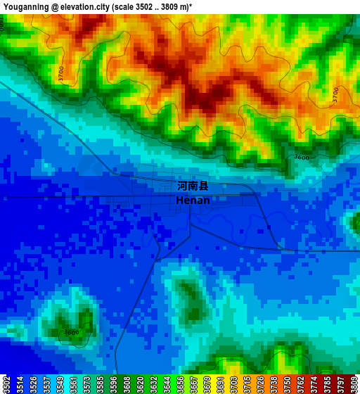
Below is the Elevation map of Youganning, which displays elevation range with different colors. Scale of the first map is from 3502 to 3809 m (11490 to 12497 ft) with average elevation of 3586.9 meters (=11768 ft) [note 1]
These maps also provides idea of topography and contour of this city, they are displayed at different zoom levels. More info about maps, scale and edge coordinates you can find below images.
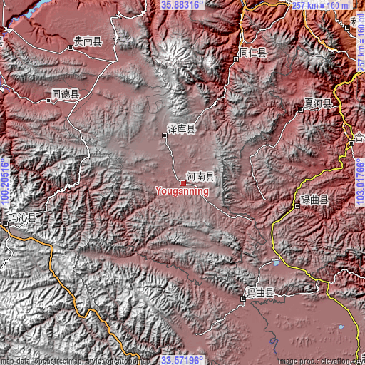
| \ | Map #1 | Topo.Map |
| Scale [m] | 3502..3809 m | × |
| Scale [ft] | 11490..12497 ft | × |
| Average | 3586.9 m = 11768 ft | × |
| Width | 8.03 km = 5 mi | 257 km = 159.7 mi |
| Height | 8.03 km = 5 mi | 257 km = 159.7 mi |
| ↑Max Latitude | 34.771746° | 35.88316° |
| Latitude at center | 34.73564° | 34.73564° |
| ↓Min Latitude | 34.699518° | 33.57196° |
| ← Min Longitude | 101.567465° | 100.20516° |
| Longitude center | 101.61141° | 101.61141° |
| →Max Longitude | 101.655355° | 103.01766° |
Nearby cities:
Cities around Youganning sort by population:
• Hanji elevation 2159 m
151.4 km,  56°
56°
• Jishi 1883 m
146.6 km,  32°
32°
• Heyin 2221 m
146.4 km,  353°
353°
• Zhiqing Songduo 3778 m
145.7 km,  186°
186°
• Magitang 2068 m
139 km,  15°
15°
• Dawu 3721 m
129.9 km,  256°
256°
• Mangqu 3082 m
122.6 km,  320°
320°
• Hezuo 2898 m
121.6 km,  76°
76°
• Gabasumdo 3113 m
112.8 km,  301°
301°
• Labuleng 2926 m
97.7 km, 58°
• Rongwo 2506 m
94.1 km, 23°
• Nyinma 3480 m
92 km,  152°
152°
Multilingual:
 En español:
Youganning elevación 3527 m.
 En France:
Youganning élévation 3527 m.
 Auf Deutsch:
Youganning höhe über dem Meeresspiegel ist 3527 m.

Sources and notes:
- [note 1] Map square and city borders are not equal. Map elevation data is calculated only from area inside that square.
- [src 1] Elevation data from geonames database provided with same terms of usage.
- [src 2] The elevation map of Youganning is generated using elevation data from NASA's 3 arcsec (90m) resolution SRTM data.
- [src 3] Base (background) map © OpenStreetMap contributors tiles are generated by Geofabrik and OpenTopoMap.
Copyright & License:
This Youganning Elevation Map is licensed under CC BY-SA. You may reuse any part from this page, if you give a proper credit by linking to this URL:
 More info on terms of use page.