Tangxiang elevation
Tangxiang (Chongqing), China elevation is 378 meters and Tangxiang elevation in feet is 1240 ft above sea level [src 1]. Tangxiang is a seat of a third-order administrative division (feature code) with elevation that is 180 meters (591 ft) smaller than average city elevation in China.
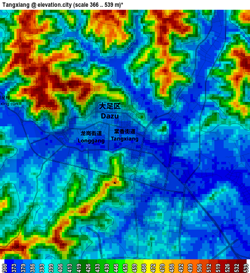
Below is the Elevation map of Tangxiang, which displays elevation range with different colors. Scale of the first map is from 366 to 539 m (1201 to 1768 ft) with average elevation of 411.9 meters (=1351 ft) [note 1]
These maps also provides idea of topography and contour of this city, they are displayed at different zoom levels. More info about maps, scale and edge coordinates you can find below images.
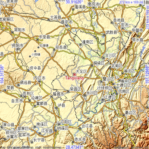
| \ | Map #1 | Topo.Map |
| Scale [m] | 366..539 m | × |
| Scale [ft] | 1201..1768 ft | × |
| Average | 411.9 m = 1351 ft | × |
| Width | 8.49 km = 5.3 mi | 271.6 km = 168.8 mi |
| Height | 8.49 km = 5.3 mi | 271.6 km = 168.8 mi |
| ↑Max Latitude | 29.740424° | 30.91626° |
| Latitude at center | 29.70226° | 29.70226° |
| ↓Min Latitude | 29.664081° | 28.47341° |
| ← Min Longitude | 105.679685° | 104.31738° |
| Longitude center | 105.72363° | 105.72363° |
| →Max Longitude | 105.767575° | 107.12988° |
Nearby cities:
Cities around Tangxiang sort by population:
• Neijiang elevation 349 m
65.3 km,  258°
258°
• Hechuan 222 m
61.3 km,  58°
58°
• Yongchuan 326 m
42.1 km,  156°
156°
• Jijiang 213 m
68.5 km,  131°
131°
• Nanjin 223 m
61 km, 58°
• Jin’e 374 m
58.3 km,  226°
226°
• Zitong 258 m
53.9 km,  10°
10°
• Bicheng 283 m
49.9 km,  103°
103°
• Zhongshanlu 312 m
42.2 km, 155°
• Changyuan 319 m
35.6 km,  201°
201°
• Bachuan 279 m
35.5 km, 62°
• Shuanglu 389 m
24.4 km,  171°
171°
Multilingual:
 En español:
Tangxiang elevación 378 m.
 En France:
Tangxiang élévation 378 m.
 Auf Deutsch:
Tangxiang höhe über dem Meeresspiegel ist 378 m.

Sources and notes:
- [note 1] Map square and city borders are not equal. Map elevation data is calculated only from area inside that square.
- [src 1] Elevation data from geonames database provided with same terms of usage.
- [src 2] The elevation map of Tangxiang is generated using elevation data from NASA's 3 arcsec (90m) resolution SRTM data.
- [src 3] Base (background) map © OpenStreetMap contributors tiles are generated by Geofabrik and OpenTopoMap.
Copyright & License:
This Tangxiang Elevation Map is licensed under CC BY-SA. You may reuse any part from this page, if you give a proper credit by linking to this URL:
 More info on terms of use page.