Jinling elevation
Jinling (Shaanxi), China elevation is 590 meters and Jinling elevation in feet is 1936 ft above sea level [src 1]. Jinling is a seat of a third-order administrative division (feature code) with elevation that is 32 meters (105 ft) bigger than average city elevation in China.
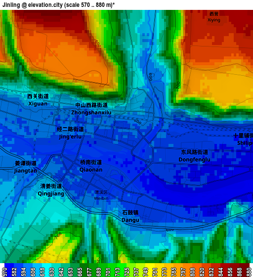
Below is the Elevation map of Jinling, which displays elevation range with different colors. Scale of the first map is from 570 to 880 m (1870 to 2887 ft) with average elevation of 659.7 meters (=2164 ft) [note 1]
These maps also provides idea of topography and contour of this city, they are displayed at different zoom levels. More info about maps, scale and edge coordinates you can find below images.
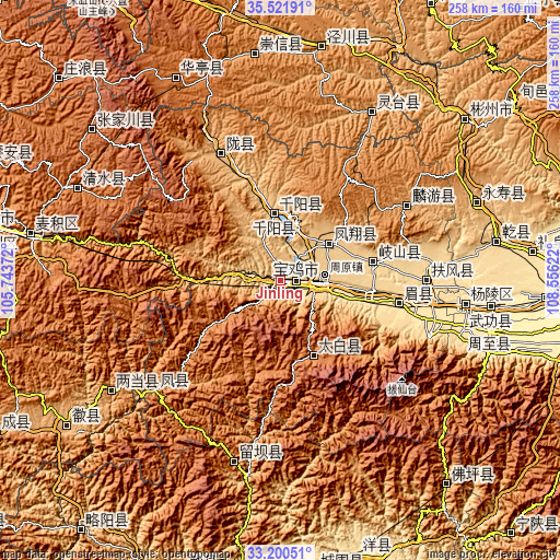
| \ | Map #1 | Topo.Map |
| Scale [m] | 570..880 m | × |
| Scale [ft] | 1870..2887 ft | × |
| Average | 659.7 m = 2164 ft | × |
| Width | 8.07 km = 5 mi | 258.1 km = 160.4 mi |
| Height | 8.07 km = 5 mi | 258.1 km = 160.4 mi |
| ↑Max Latitude | 34.405515° | 35.52191° |
| Latitude at center | 34.36925° | 34.36925° |
| ↓Min Latitude | 34.332969° | 33.20051° |
| ← Min Longitude | 107.106025° | 105.74372° |
| Longitude center | 107.14997° | 107.14997° |
| →Max Longitude | 107.193915° | 108.55622° |
Nearby cities:
Cities around Jinling sort by population:
• Guozhen elevation 551 m
19.2 km,  91°
91°
• Shuangshipu 962 m
76.4 km,  228°
228°
• Jiuchenggong 1038 m
67.8 km,  59°
59°
• Fufeng 531 m
66.4 km, 90°
• Longxian Chengguanzhen 973 m
65.8 km,  335°
335°
• Shoushan 522 m
55.7 km,  100°
100°
• Fengming 677 m
43.7 km,  79°
79°
• Zuitou 1542 m
37.3 km,  156°
156°
• Qianyang Chengguanzhen 733 m
30.4 km,  356°
356°
• Fengxiang Chengguanzhen 794 m
28 km,  52°
52°
• Baoji 567 m
8 km, 91°
• Zhongshan Donglu 656 m
1.2 km, 344°
Multilingual:
 En español:
Jinling elevación 590 m.
 En France:
Jinling élévation 590 m.


Sources and notes:
- [note 1] Map square and city borders are not equal. Map elevation data is calculated only from area inside that square.
- [src 1] Elevation data from geonames database provided with same terms of usage.
- [src 2] The elevation map of Jinling is generated using elevation data from NASA's 3 arcsec (90m) resolution SRTM data.
- [src 3] Base (background) map © OpenStreetMap contributors tiles are generated by Geofabrik and OpenTopoMap.
Copyright & License:
This Jinling Elevation Map is licensed under CC BY-SA. You may reuse any part from this page, if you give a proper credit by linking to this URL:
 More info on terms of use page.