Shuangshipu elevation
Shuangshipu (Shaanxi), China elevation is 962 meters and Shuangshipu elevation in feet is 3156 ft above sea level [src 1]. Shuangshipu is a seat of a third-order administrative division (feature code) with elevation that is 404 meters (1325 ft) bigger than average city elevation in China.
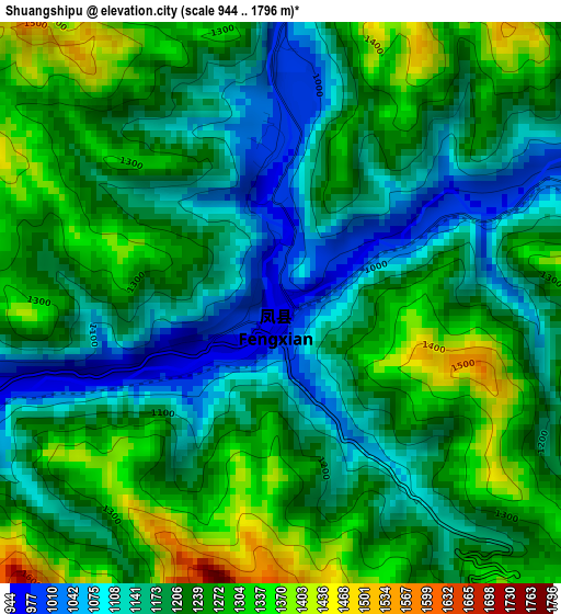
Below is the Elevation map of Shuangshipu, which displays elevation range with different colors. Scale of the first map is from 944 to 1796 m (3097 to 5892 ft) with average elevation of 1215 meters (=3986 ft) [note 1]
These maps also provides idea of topography and contour of this city, they are displayed at different zoom levels. More info about maps, scale and edge coordinates you can find below images.
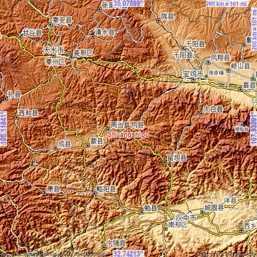
| \ | Map #1 | Topo.Map |
| Scale [m] | 944..1796 m | × |
| Scale [ft] | 3097..5892 ft | × |
| Average | 1215 m = 3986 ft | × |
| Width | 8.11 km = 5 mi | 259.5 km = 161.2 mi |
| Height | 8.11 km = 5 mi | 259.5 km = 161.2 mi |
| ↑Max Latitude | 33.95351° | 35.07599° |
| Latitude at center | 33.91705° | 33.91705° |
| ↓Min Latitude | 33.880574° | 32.74213° |
| ← Min Longitude | 106.480715° | 105.11841° |
| Longitude center | 106.52466° | 106.52466° |
| →Max Longitude | 106.568605° | 107.93091° |
Nearby cities:
Cities around Shuangshipu sort by population:
• Guozhen elevation 551 m
91.6 km,  56°
56°
• Beidao 1087 m
92.8 km,  321°
321°
• Mianyang 549 m
86 km,  169°
169°
• Baoji 567 m
82.5 km,  52°
52°
• Zhongshan Donglu 656 m
76.9 km, 48°
• Jinling 590 m
76.4 km, 48°
• Chengxian Chengguanzhen 993 m
75.5 km,  255°
255°
• Zuitou 1542 m
74.4 km,  77°
77°
• Lüeyang Chengguanzhen 745 m
73.5 km,  207°
207°
• Liuba 988 m
49.3 km,  132°
132°
• Huixian Chengguanzhen 911 m
44.2 km,  248°
248°
• Liangdang Chengguanzhen 965 m
20.5 km,  267°
267°
Multilingual:
 En español:
Shuangshipu elevación 962 m.
 En France:
Shuangshipu élévation 962 m.
 Auf Deutsch:
Shuangshipu höhe über dem Meeresspiegel ist 962 m.

Sources and notes:
- [note 1] Map square and city borders are not equal. Map elevation data is calculated only from area inside that square.
- [src 1] Elevation data from geonames database provided with same terms of usage.
- [src 2] The elevation map of Shuangshipu is generated using elevation data from NASA's 3 arcsec (90m) resolution SRTM data.
- [src 3] Base (background) map © OpenStreetMap contributors tiles are generated by Geofabrik and OpenTopoMap.
Copyright & License:
This Shuangshipu Elevation Map is licensed under CC BY-SA. You may reuse any part from this page, if you give a proper credit by linking to this URL:
 More info on terms of use page.