Fuli elevation
Fuli (Heilongjiang), China elevation is 104 meters and Fuli elevation in feet is 341 ft above sea level [src 1]. Fuli is a populated place (feature code) with elevation that is 454 meters (1490 ft) smaller than average city elevation in China.
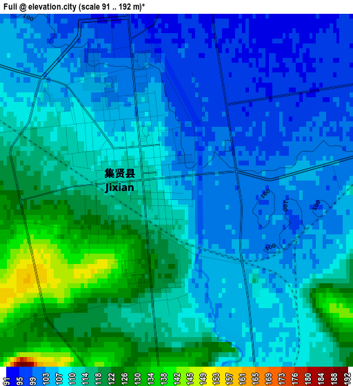
Below is the Elevation map of Fuli, which displays elevation range with different colors. Scale of the first map is from 91 to 192 m (299 to 630 ft) with average elevation of 110.1 meters (=361 ft) [note 1]
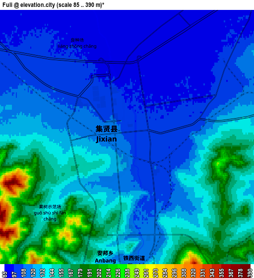
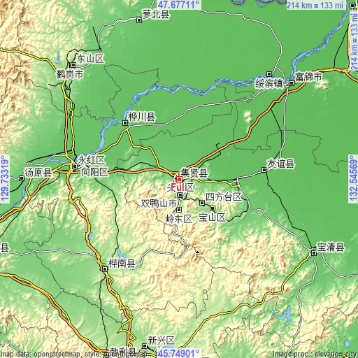
These maps also provides idea of topography and contour of this city, they are displayed at different zoom levels. More info about maps, scale and edge coordinates you can find below images.
| \ | Map #1 | Map #2 | Topo.Map |
| Scale [m] | 91..192 m | 85..390 m | × |
| Scale [ft] | 299..630 ft | 279..1280 ft | × |
| Average | 110.1 m = 361 ft | 129.9 m = 426 ft | × |
| Width | 6.7 km = 4.2 mi | 13.4 km = 8.3 mi | 214.4 km = 133.2 mi |
| Height | 6.7 km = 4.2 mi | 13.4 km = 8.3 mi | 214.4 km = 133.2 mi |
| ↑Max Latitude | 46.751788° | 46.781889° | 47.67711° |
| Latitude at center | 46.72167° | 46.72167° | 46.72167° |
| ↓Min Latitude | 46.691535° | 46.661384° | 45.74901° |
| ← Min Longitude | 131.095495° | 131.051549° | 129.73319° |
| Longitude center | 131.13944° | 131.13944° | 131.13944° |
| →Max Longitude | 131.183385° | 131.227331° | 132.54569° |
Nearby cities:
Cities around Fuli sort by population:
• Shuangyashan elevation 200 m
9.6 km,  173°
173°
• Jiamusi 81 m
63.3 km,  277°
277°
• Baoshan 167 m
28.3 km,  129°
129°
• Fujin 62 m
90.4 km,  48°
48°
• Lingdong 171 m
17.2 km,  178°
178°
• Huanan 171 m
72.9 km,  220°
220°
• Xing’an 138 m
90.9 km,  309°
309°
• Youyi 83 m
63.2 km, 278°
• Qiaonan 84 m
60.2 km, 278°
• Zhanqian 81 m
58.8 km, 278°
• Jianguo 80 m
57.6 km, 280°
• Yuelai 77 m
46.6 km,  315°
315°
Multilingual:
 En español:
Fuli elevación 104 m.
 En France:
Fuli élévation 104 m.


Sources and notes:
- [note 1] Map square and city borders are not equal. Map elevation data is calculated only from area inside that square.
- [src 1] Elevation data from geonames database provided with same terms of usage.
- [src 2] The elevation map of Fuli is generated using elevation data from NASA's 3 arcsec (90m) resolution SRTM data.
- [src 3] Base (background) map © OpenStreetMap contributors tiles are generated by Geofabrik and OpenTopoMap.
Copyright & License:
This Fuli Elevation Map is licensed under CC BY-SA. You may reuse any part from this page, if you give a proper credit by linking to this URL:
 More info on terms of use page.