Huanan elevation
Huanan (Heilongjiang), China elevation is 171 meters and Huanan elevation in feet is 561 ft above sea level [src 1]. Huanan is a seat of a third-order administrative division (feature code) with elevation that is 387 meters (1270 ft) smaller than average city elevation in China.
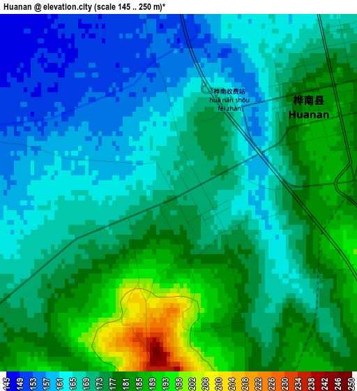
Below is the Elevation map of Huanan, which displays elevation range with different colors. Scale of the first map is from 145 to 250 m (476 to 820 ft) with average elevation of 172.7 meters (=567 ft) [note 1]
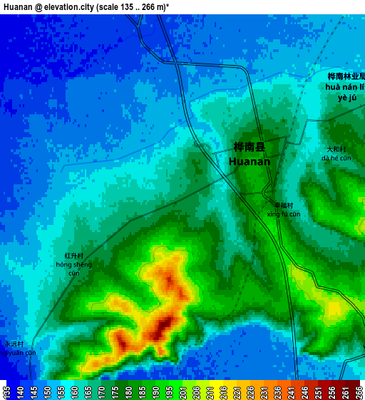
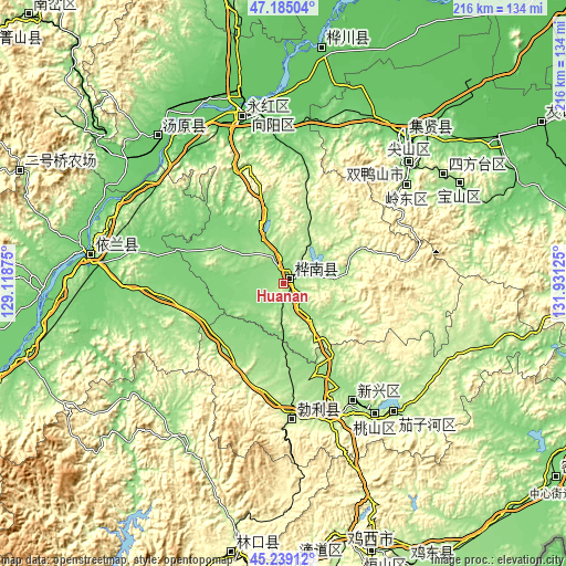
These maps also provides idea of topography and contour of this city, they are displayed at different zoom levels. More info about maps, scale and edge coordinates you can find below images.
| \ | Map #1 | Map #2 | Topo.Map |
| Scale [m] | 145..250 m | 135..266 m | × |
| Scale [ft] | 476..820 ft | 443..873 ft | × |
| Average | 172.7 m = 567 ft | 165.6 m = 543 ft | × |
| Width | 6.76 km = 4.2 mi | 13.52 km = 8.4 mi | 216.4 km = 134.5 mi |
| Height | 6.76 km = 4.2 mi | 13.52 km = 8.4 mi | 216.4 km = 134.5 mi |
| ↑Max Latitude | 46.251097° | 46.281476° | 47.18504° |
| Latitude at center | 46.2207° | 46.2207° | 46.2207° |
| ↓Min Latitude | 46.190287° | 46.159856° | 45.23912° |
| ← Min Longitude | 130.481055° | 130.437109° | 129.11875° |
| Longitude center | 130.525° | 130.525° | 130.525° |
| →Max Longitude | 130.568945° | 130.612891° | 131.93125° |
Nearby cities:
Cities around Huanan sort by population:
• Shuangyashan elevation 200 m
66.8 km,  46°
46°
• Jiamusi 81 m
66.3 km,  346°
346°
• Taihecun 198 m
56.7 km,  153°
153°
• Boli 218 m
52.2 km,  175°
175°
• Lingdong 171 m
61.2 km, 51°
• Fuli 104 m
72.9 km,  40°
40°
• Tangyuan 92 m
73.9 km,  319°
319°
• Jianguo 80 m
67.1 km, 351°
• Youyi 83 m
66.8 km, 346°
• Qiaonan 84 m
66.1 km, 348°
• Zhanqian 81 m
65.4 km, 349°
• Beishan 188 m
54.7 km, 145°
Multilingual:
 En español:
Huanan elevación 171 m.
 En France:
Huanan élévation 171 m.


Sources and notes:
- [note 1] Map square and city borders are not equal. Map elevation data is calculated only from area inside that square.
- [src 1] Elevation data from geonames database provided with same terms of usage.
- [src 2] The elevation map of Huanan is generated using elevation data from NASA's 3 arcsec (90m) resolution SRTM data.
- [src 3] Base (background) map © OpenStreetMap contributors tiles are generated by Geofabrik and OpenTopoMap.
Copyright & License:
This Huanan Elevation Map is licensed under CC BY-SA. You may reuse any part from this page, if you give a proper credit by linking to this URL:
 More info on terms of use page.