Kangbao elevation
Kangbao (Hebei), China elevation is 1413 meters and Kangbao elevation in feet is 4636 ft above sea level [src 1]. Kangbao is a seat of a third-order administrative division (feature code) with elevation that is 855 meters (2805 ft) bigger than average city elevation in China.
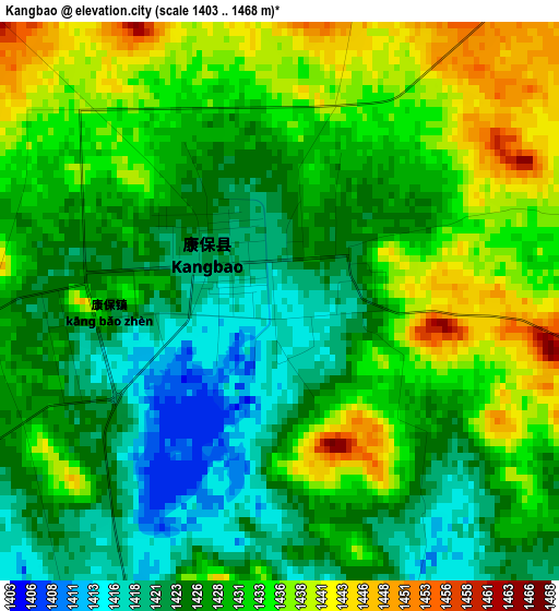
Below is the Elevation map of Kangbao, which displays elevation range with different colors. Scale of the first map is from 1403 to 1468 m (4603 to 4816 ft) with average elevation of 1429 meters (=4688 ft) [note 1]
These maps also provides idea of topography and contour of this city, they are displayed at different zoom levels. More info about maps, scale and edge coordinates you can find below images.
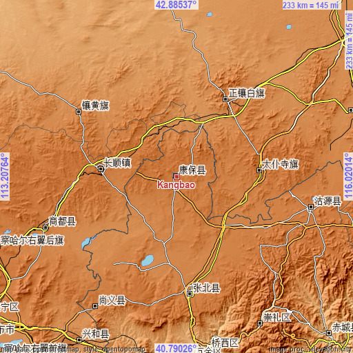
| \ | Map #1 | Topo.Map |
| Scale [m] | 1403..1468 m | × |
| Scale [ft] | 4603..4816 ft | × |
| Average | 1429 m = 4688 ft | × |
| Width | 7.28 km = 4.5 mi | 233 km = 144.8 mi |
| Height | 7.28 km = 4.5 mi | 232.9 km = 144.7 mi |
| ↑Max Latitude | 41.879118° | 42.88537° |
| Latitude at center | 41.84639° | 41.84639° |
| ↓Min Latitude | 41.813645° | 40.79026° |
| ← Min Longitude | 114.569945° | 113.20764° |
| Longitude center | 114.61389° | 114.61389° |
| →Max Longitude | 114.657835° | 116.02014° |
Nearby cities:
Cities around Kangbao sort by population:
• Zhangjiakou elevation 758 m
117.3 km,  169°
169°
• Shangdu 1303 m
123.5 km,  68°
68°
• Kongjiazhuang 734 m
122 km,  175°
175°
• Xiwanzi 1245 m
111.7 km,  150°
150°
• Nanhaoqian 1348 m
102.3 km,  212°
212°
• Qitai 1371 m
95.5 km,  249°
249°
• Pingdingbu 1412 m
92.1 km,  102°
102°
• Xin Bulag 1329 m
77.5 km,  304°
304°
• Zhangbei 1396 m
77.5 km, 174°
• Ming’antu 1341 m
59.6 km,  31°
31°
• Baochang 1456 m
55.2 km,  85°
85°
• Changshun 1485 m
51.7 km,  275°
275°
Multilingual:
 En español:
Kangbao elevación 1413 m.
 En France:
Kangbao élévation 1413 m.
 Auf Deutsch:
Kangbao höhe über dem Meeresspiegel ist 1413 m.

Sources and notes:
- [note 1] Map square and city borders are not equal. Map elevation data is calculated only from area inside that square.
- [src 1] Elevation data from geonames database provided with same terms of usage.
- [src 2] The elevation map of Kangbao is generated using elevation data from NASA's 3 arcsec (90m) resolution SRTM data.
- [src 3] Base (background) map © OpenStreetMap contributors tiles are generated by Geofabrik and OpenTopoMap.
Copyright & License:
This Kangbao Elevation Map is licensed under CC BY-SA. You may reuse any part from this page, if you give a proper credit by linking to this URL:
 More info on terms of use page.