Changsha elevation
Changsha (Hunan, Changsha Shi), China elevation is 67 meters and Changsha elevation in feet is 220 ft above sea level [src 1]. Changsha is a seat of a first-order administrative division (feature code) with elevation that is 491 meters (1611 ft) smaller than average city elevation in China.
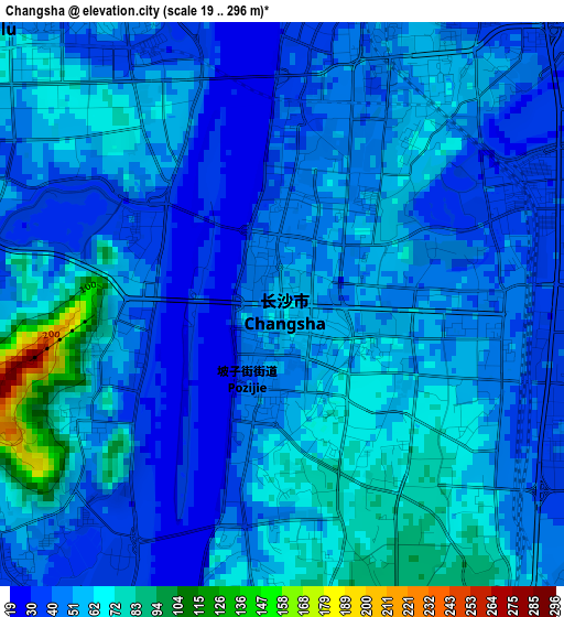
Below is the Elevation map of Changsha, which displays elevation range with different colors. Scale of the first map is from 19 to 296 m (62 to 971 ft) with average elevation of 52.2 meters (=171 ft) [note 1]
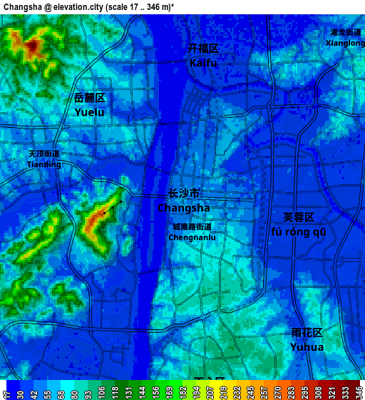
These maps also provides idea of topography and contour of this city, they are displayed at different zoom levels. More info about maps, scale and edge coordinates you can find below images.
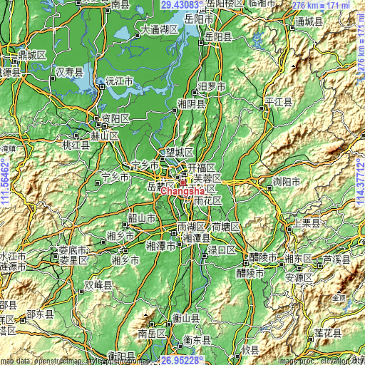
| \ | Map #1 | Map #2 | Topo.Map |
| Scale [m] | 19..296 m | 17..346 m | × |
| Scale [ft] | 62..971 ft | 56..1135 ft | × |
| Average | 52.2 m = 171 ft | 56.3 m = 185 ft | × |
| Width | 8.61 km = 5.3 mi | 17.23 km = 10.7 mi | 275.6 km = 171.2 mi |
| Height | 8.61 km = 5.3 mi | 17.23 km = 10.7 mi | 275.6 km = 171.2 mi |
| ↑Max Latitude | 28.237463° | 28.276171° | 29.43083° |
| Latitude at center | 28.19874° | 28.19874° | 28.19874° |
| ↓Min Latitude | 28.160003° | 28.121253° | 26.95228° |
| ← Min Longitude | 112.926925° | 112.882979° | 111.56462° |
| Longitude center | 112.97087° | 112.97087° | 112.97087° |
| →Max Longitude | 113.014815° | 113.058761° | 114.37712° |
Nearby cities:
Cities around Changsha sort by population:
• Zhuzhou elevation 54 m
44.3 km,  156°
156°
• Xiangtan 31 m
39.4 km,  190°
190°
• Wenxing 51 m
54.5 km,  350°
350°
• Yutan 53 m
40.7 km,  279°
279°
• Yisuhe 39 m
48.4 km, 185°
• Gaotangling 28 m
24 km,  321°
321°
• Xingsha 69 m
12.3 km,  68°
68°
• Guitang 79 m
9.6 km,  132°
132°
• Qingyuan 62 m
9.5 km, 163°
• Wangyue 70 m
6.7 km,  308°
308°
• Dongtundu 33 m
6.2 km,  105°
105°
• Furong Beilu 39 m
4.4 km,  12°
12°
Multilingual:
 En español:
Changsha elevación 67 m.
 En France:
Changsha élévation 67 m.


Sources and notes:
- [note 1] Map square and city borders are not equal. Map elevation data is calculated only from area inside that square.
- [src 1] Elevation data from geonames database provided with same terms of usage.
- [src 2] The elevation map of Changsha is generated using elevation data from NASA's 3 arcsec (90m) resolution SRTM data.
- [src 3] Base (background) map © OpenStreetMap contributors tiles are generated by Geofabrik and OpenTopoMap.
Copyright & License:
This Changsha Elevation Map is licensed under CC BY-SA. You may reuse any part from this page, if you give a proper credit by linking to this URL:
 More info on terms of use page.