Puxi elevation
Puxi (Henan), China elevation is 64 meters and Puxi elevation in feet is 210 ft above sea level [src 1]. Puxi is a seat of a third-order administrative division (feature code) with elevation that is 494 meters (1621 ft) smaller than average city elevation in China.
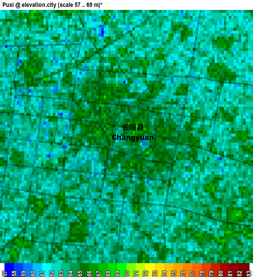
Below is the Elevation map of Puxi, which displays elevation range with different colors. Scale of the first map is from 57 to 69 m (187 to 226 ft) with average elevation of 63.1 meters (=207 ft) [note 1]
These maps also provides idea of topography and contour of this city, they are displayed at different zoom levels. More info about maps, scale and edge coordinates you can find below images.
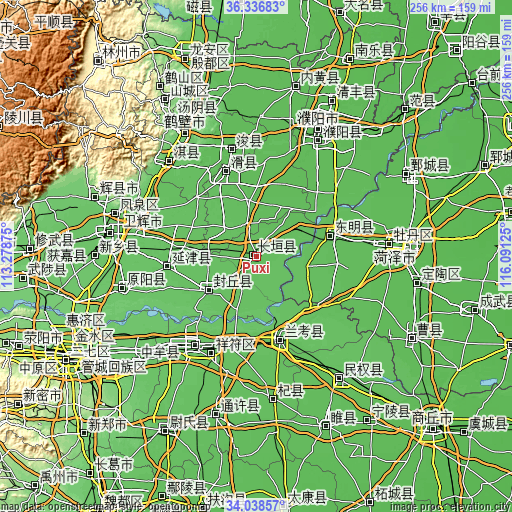
| \ | Map #1 | Topo.Map |
| Scale [m] | 57..69 m | × |
| Scale [ft] | 187..226 ft | × |
| Average | 63.1 m = 207 ft | × |
| Width | 7.99 km = 5 mi | 255.5 km = 158.8 mi |
| Height | 7.99 km = 5 mi | 255.5 km = 158.8 mi |
| ↑Max Latitude | 35.231734° | 36.33683° |
| Latitude at center | 35.19583° | 35.19583° |
| ↓Min Latitude | 35.159911° | 34.03857° |
| ← Min Longitude | 114.641055° | 113.27875° |
| Longitude center | 114.685° | 114.685° |
| →Max Longitude | 114.728945° | 116.09125° |
Nearby cities:
Cities around Puxi sort by population:
• Kaifeng elevation 76 m
56 km,  217°
217°
• Puyang Chengguanzhen 56 m
64 km,  27°
27°
• Daokou 64 m
44 km,  338°
338°
• Chaoge 73 m
64 km,  315°
315°
• Chengjiao 71 m
61.3 km,  292°
292°
• Xun Xian Chengguanzhen 61 m
53.9 km,  345°
345°
• Yanjin Chengguanzhen 70 m
45.6 km,  262°
262°
• Lankao Chengguanzhen 70 m
41.9 km,  164°
164°
• Chengguan 57 m
41.4 km,  72°
72°
• Dongming Chengguanzhen 61 m
38.3 km, 73°
• Fengqiu Chengguanzhen 68 m
30.9 km,  233°
233°
• Changyuan County 63 m
4.9 km, 67°
Multilingual:
 En español:
Puxi elevación 64 m.
 En France:
Puxi élévation 64 m.


Sources and notes:
- [note 1] Map square and city borders are not equal. Map elevation data is calculated only from area inside that square.
- [src 1] Elevation data from geonames database provided with same terms of usage.
- [src 2] The elevation map of Puxi is generated using elevation data from NASA's 3 arcsec (90m) resolution SRTM data.
- [src 3] Base (background) map © OpenStreetMap contributors tiles are generated by Geofabrik and OpenTopoMap.
Copyright & License:
This Puxi Elevation Map is licensed under CC BY-SA. You may reuse any part from this page, if you give a proper credit by linking to this URL:
 More info on terms of use page.