Fengqiu Chengguanzhen elevation
Fengqiu Chengguanzhen (Henan), China elevation is 68 meters and Fengqiu Chengguanzhen elevation in feet is 223 ft above sea level [src 1]. Fengqiu Chengguanzhen is a seat of a third-order administrative division (feature code) with elevation that is 490 meters (1608 ft) smaller than average city elevation in China.
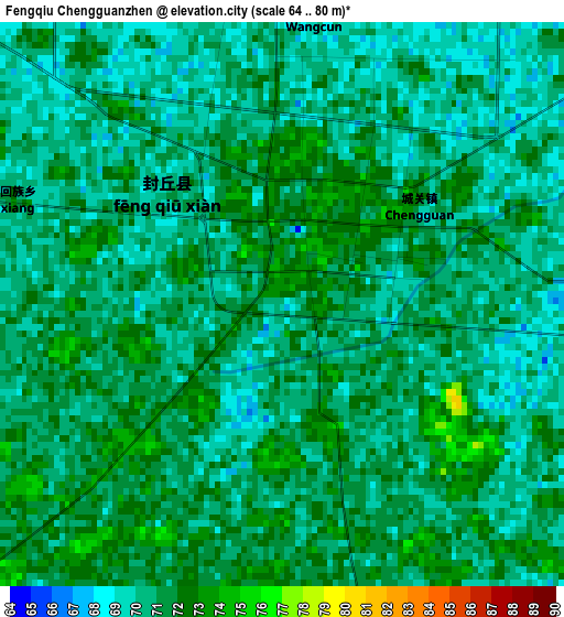
Below is the Elevation map of Fengqiu Chengguanzhen, which displays elevation range with different colors. Scale of the first map is from 64 to 80 m (210 to 262 ft) with average elevation of 70.5 meters (=231 ft) [note 1]
These maps also provides idea of topography and contour of this city, they are displayed at different zoom levels. More info about maps, scale and edge coordinates you can find below images.
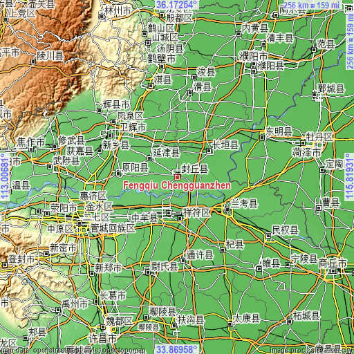
| \ | Map #1 | Topo.Map |
| Scale [m] | 64..80 m | × |
| Scale [ft] | 210..262 ft | × |
| Average | 70.5 m = 231 ft | × |
| Width | 8 km = 5 mi | 256.1 km = 159.1 mi |
| Height | 8 km = 5 mi | 256.1 km = 159.1 mi |
| ↑Max Latitude | 35.065147° | 36.17254° |
| Latitude at center | 35.02917° | 35.02917° |
| ↓Min Latitude | 34.993177° | 33.86958° |
| ← Min Longitude | 114.369115° | 113.00681° |
| Longitude center | 114.41306° | 114.41306° |
| →Max Longitude | 114.457005° | 115.81931° |
Nearby cities:
Cities around Fengqiu Chengguanzhen sort by population:
• Kaifeng elevation 76 m
27.4 km,  200°
200°
• Xinxiang 82 m
58.4 km,  287°
287°
• Daokou 64 m
60 km,  8°
8°
• Qi Xian Chengguanzhen 62 m
63.1 km,  147°
147°
• Tongxu Chengguanzhen 67 m
61.5 km,  176°
176°
• Zhongmu Chengguanzhen 79 m
54 km,  229°
229°
• Chengjiao 71 m
52.6 km,  322°
322°
• Lankao Chengguanzhen 70 m
42 km,  121°
121°
• Yuanyang Chengguanzhen 80 m
41 km,  273°
273°
• Changyuan County 63 m
35.7 km,  55°
55°
• Puxi 64 m
30.9 km,  53°
53°
• Yanjin Chengguanzhen 70 m
24 km,  301°
301°
Multilingual:
 En español:
Fengqiu Chengguanzhen elevación 68 m.
 En France:
Fengqiu Chengguanzhen élévation 68 m.
 Auf Deutsch:
Fengqiu Chengguanzhen höhe über dem Meeresspiegel ist 68 m.
 На русском:
Fengqiu Chengguanzhen высота над уровнем моря 68 м
Sources and notes:
- [note 1] Map square and city borders are not equal. Map elevation data is calculated only from area inside that square.
- [src 1] Elevation data from geonames database provided with same terms of usage.
- [src 2] The elevation map of Fengqiu Chengguanzhen is generated using elevation data from NASA's 3 arcsec (90m) resolution SRTM data.
- [src 3] Base (background) map © OpenStreetMap contributors tiles are generated by Geofabrik and OpenTopoMap.
Copyright & License:
This Fengqiu Chengguanzhen Elevation Map is licensed under CC BY-SA. You may reuse any part from this page, if you give a proper credit by linking to this URL:
 More info on terms of use page.