Cuihua elevation
Cuihua (Yunnan), China elevation is 1794 meters and Cuihua elevation in feet is 5886 ft above sea level [src 1]. Cuihua is a seat of a third-order administrative division (feature code) with elevation that is 1236 meters (4055 ft) bigger than average city elevation in China.
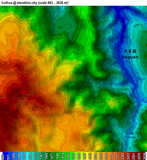
Below is the Elevation map of Cuihua, which displays elevation range with different colors. Scale of the first map is from 863 to 2638 m (2831 to 8655 ft) with average elevation of 1729.4 meters (=5674 ft) [note 1]
These maps also provides idea of topography and contour of this city, they are displayed at different zoom levels. More info about maps, scale and edge coordinates you can find below images.
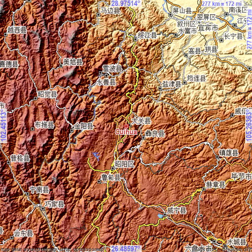
| \ | Map #1 | Topo.Map |
| Scale [m] | 863..2638 m | × |
| Scale [ft] | 2831..8655 ft | × |
| Average | 1729.4 m = 5674 ft | × |
| Width | 8.65 km = 5.4 mi | 276.8 km = 172 mi |
| Height | 8.65 km = 5.4 mi | 276.8 km = 172 mi |
| ↑Max Latitude | 27.776549° | 28.97514° |
| Latitude at center | 27.73766° | 27.73766° |
| ↓Min Latitude | 27.698758° | 26.48597° |
| ← Min Longitude | 103.813435° | 102.45113° |
| Longitude center | 103.85738° | 103.85738° |
| →Max Longitude | 103.901325° | 105.26363° |
Nearby cities:
Cities around Cuihua sort by population:
• Zhaotong elevation 1974 m
48.8 km,  196°
196°
• Temuli 2397 m
103.4 km,  268°
268°
• Wufeng 1892 m
101.4 km,  108°
108°
• Qingfu 339 m
101.1 km,  39°
39°
• Zhongcheng 475 m
95.2 km,  4°
4°
• Junlian 450 m
80.3 km,  53°
53°
• Wenping 2018 m
68.8 km,  208°
208°
• Jincheng 1211 m
65.3 km,  334°
334°
• Xiluodu 877 m
60.3 km,  339°
339°
• Tiandiba 1347 m
60.1 km, 266°
• Yanjing 1010 m
50.7 km, 40°
• Jiaokui 1256 m
21.6 km,  137°
137°
Multilingual:
 En español:
Cuihua elevación 1794 m.
 En France:
Cuihua élévation 1794 m.


Sources and notes:
- [note 1] Map square and city borders are not equal. Map elevation data is calculated only from area inside that square.
- [src 1] Elevation data from geonames database provided with same terms of usage.
- [src 2] The elevation map of Cuihua is generated using elevation data from NASA's 3 arcsec (90m) resolution SRTM data.
- [src 3] Base (background) map © OpenStreetMap contributors tiles are generated by Geofabrik and OpenTopoMap.
Copyright & License:
This Cuihua Elevation Map is licensed under CC BY-SA. You may reuse any part from this page, if you give a proper credit by linking to this URL:
 More info on terms of use page.