Qingfu elevation
Qingfu (Sichuan), China elevation is 339 meters and Qingfu elevation in feet is 1112 ft above sea level [src 1]. Qingfu is a seat of a third-order administrative division (feature code) with elevation that is 219 meters (719 ft) smaller than average city elevation in China.
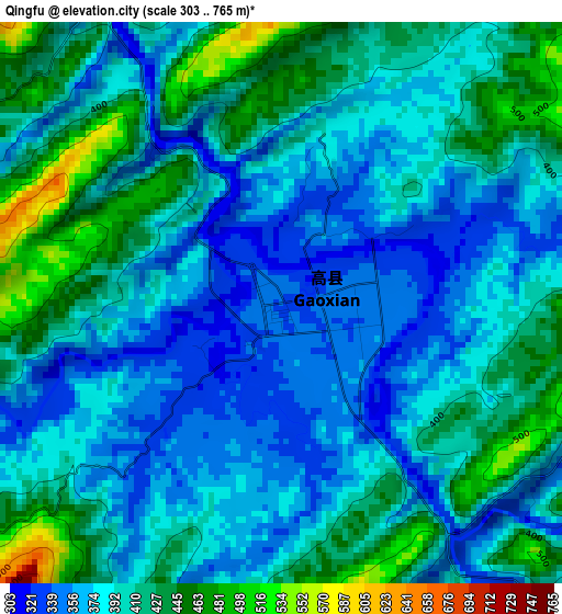
Below is the Elevation map of Qingfu, which displays elevation range with different colors. Scale of the first map is from 303 to 765 m (994 to 2510 ft) with average elevation of 396 meters (=1299 ft) [note 1]
These maps also provides idea of topography and contour of this city, they are displayed at different zoom levels. More info about maps, scale and edge coordinates you can find below images.
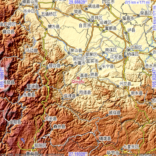
| \ | Map #1 | Topo.Map |
| Scale [m] | 303..765 m | × |
| Scale [ft] | 994..2510 ft | × |
| Average | 396 m = 1299 ft | × |
| Width | 8.59 km = 5.3 mi | 275 km = 170.9 mi |
| Height | 8.59 km = 5.3 mi | 275 km = 170.9 mi |
| ↑Max Latitude | 28.475646° | 29.66629° |
| Latitude at center | 28.43701° | 28.43701° |
| ↓Min Latitude | 28.39836° | 27.19328° |
| ← Min Longitude | 104.472275° | 103.10997° |
| Longitude center | 104.51622° | 104.51622° |
| →Max Longitude | 104.560165° | 105.92247° |
Nearby cities:
Cities around Qingfu sort by population:
• Yibin elevation 291 m
38.1 km,  15°
15°
• Xunchang 515 m
19.5 km,  84°
84°
• Zhongcheng 354 m
71.3 km,  101°
101°
• Nanxi 274 m
63.8 km,  45°
45°
• Jiang’an 282 m
63.2 km,  58°
58°
• Zhongcheng 475 m
58.9 km,  286°
286°
• Yanjing 1010 m
50.5 km,  218°
218°
• Xinfa 290 m
47.8 km,  336°
336°
• Changning 264 m
42.5 km,  68°
68°
• Junlian 450 m
29.6 km,  180°
180°
• Baixi 296 m
29.4 km,  6°
6°
• Xiangjiaba 318 m
24.4 km,  333°
333°
Multilingual:
 En español:
Qingfu elevación 339 m.
 En France:
Qingfu élévation 339 m.


Sources and notes:
- [note 1] Map square and city borders are not equal. Map elevation data is calculated only from area inside that square.
- [src 1] Elevation data from geonames database provided with same terms of usage.
- [src 2] The elevation map of Qingfu is generated using elevation data from NASA's 3 arcsec (90m) resolution SRTM data.
- [src 3] Base (background) map © OpenStreetMap contributors tiles are generated by Geofabrik and OpenTopoMap.
Copyright & License:
This Qingfu Elevation Map is licensed under CC BY-SA. You may reuse any part from this page, if you give a proper credit by linking to this URL:
 More info on terms of use page.