Dabaozi elevation
Dabaozi (Hunan), China elevation is 404 meters and Dabaozi elevation in feet is 1325 ft above sea level [src 1]. Dabaozi is a populated place (feature code) with elevation that is 154 meters (505 ft) smaller than average city elevation in China.
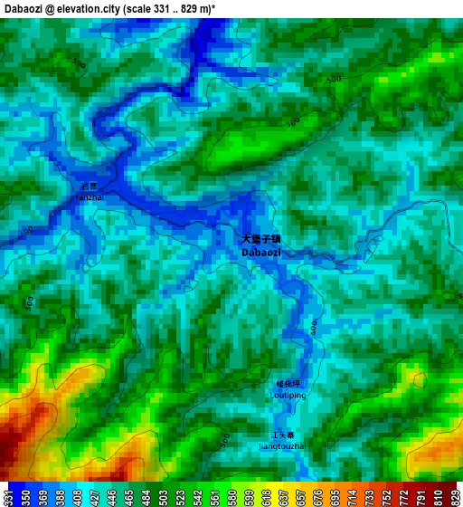
Below is the Elevation map of Dabaozi, which displays elevation range with different colors. Scale of the first map is from 331 to 829 m (1086 to 2720 ft) with average elevation of 469.1 meters (=1539 ft) [note 1]
These maps also provides idea of topography and contour of this city, they are displayed at different zoom levels. More info about maps, scale and edge coordinates you can find below images.
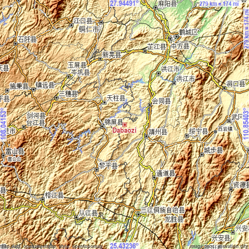
| \ | Map #1 | Topo.Map |
| Scale [m] | 331..829 m | × |
| Scale [ft] | 1086..2720 ft | × |
| Average | 469.1 m = 1539 ft | × |
| Width | 8.73 km = 5.4 mi | 279.4 km = 173.6 mi |
| Height | 8.73 km = 5.4 mi | 279.4 km = 173.6 mi |
| ↑Max Latitude | 26.734814° | 27.94491° |
| Latitude at center | 26.69556° | 26.69556° |
| ↓Min Latitude | 26.656292° | 25.43236° |
| ← Min Longitude | 109.403835° | 108.04153° |
| Longitude center | 109.44778° | 109.44778° |
| →Max Longitude | 109.491725° | 110.85403° |
Nearby cities:
Cities around Dabaozi sort by population:
• Gaoniang elevation 607 m
31.3 km,  301°
301°
• Baishi 284 m
30.9 km,  359°
359°
• Pukou 432 m
22.1 km,  150°
150°
• Benchu 284 m
17.7 km, 298°
• Lantian 354 m
39.7 km,  337°
337°
• Ouyang 395 m
38.4 km,  216°
216°
• Tonggu 436 m
19.4 km,  225°
225°
• Maoping 351 m
23 km,  281°
281°
• Runsong 438 m
39.9 km, 299°
• Lincheng 263 m
28.8 km,  47°
47°
• Sanjiang 311 m
25.1 km,  264°
264°
• Quyang 440 m
23.2 km,  125°
125°
Multilingual:
 En español:
Dabaozi elevación 404 m.
 En France:
Dabaozi élévation 404 m.


Sources and notes:
- [note 1] Map square and city borders are not equal. Map elevation data is calculated only from area inside that square.
- [src 1] Elevation data from geonames database provided with same terms of usage.
- [src 2] The elevation map of Dabaozi is generated using elevation data from NASA's 3 arcsec (90m) resolution SRTM data.
- [src 3] Base (background) map © OpenStreetMap contributors tiles are generated by Geofabrik and OpenTopoMap.
Copyright & License:
This Dabaozi Elevation Map is licensed under CC BY-SA. You may reuse any part from this page, if you give a proper credit by linking to this URL:
 More info on terms of use page.