Sanjiang elevation
Sanjiang (Guizhou), China elevation is 311 meters and Sanjiang elevation in feet is 1020 ft above sea level [src 1]. Sanjiang is a seat of a third-order administrative division (feature code) with elevation that is 247 meters (810 ft) smaller than average city elevation in China.
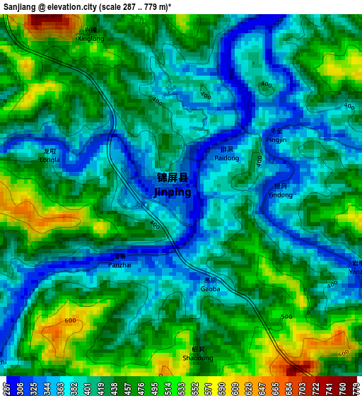
Below is the Elevation map of Sanjiang, which displays elevation range with different colors. Scale of the first map is from 287 to 779 m (942 to 2556 ft) with average elevation of 431.6 meters (=1416 ft) [note 1]
These maps also provides idea of topography and contour of this city, they are displayed at different zoom levels. More info about maps, scale and edge coordinates you can find below images.
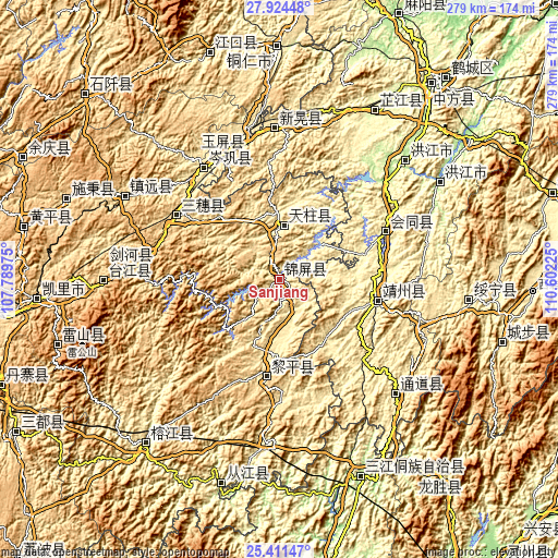
| \ | Map #1 | Topo.Map |
| Scale [m] | 287..779 m | × |
| Scale [ft] | 942..2556 ft | × |
| Average | 431.6 m = 1416 ft | × |
| Width | 8.73 km = 5.4 mi | 279.4 km = 173.6 mi |
| Height | 8.73 km = 5.4 mi | 279.4 km = 173.6 mi |
| ↑Max Latitude | 26.714161° | 27.92448° |
| Latitude at center | 26.6749° | 26.6749° |
| ↓Min Latitude | 26.635625° | 25.41147° |
| ← Min Longitude | 109.152055° | 107.78975° |
| Longitude center | 109.196° | 109.196° |
| →Max Longitude | 109.239945° | 110.60225° |
Nearby cities:
Cities around Sanjiang sort by population:
• Gaoniang elevation 607 m
18.7 km,  354°
354°
• Longlisuo 456 m
30.5 km,  197°
197°
• Pukou 432 m
39.6 km,  115°
115°
• Aoshi 453 m
32.8 km, 202°
• Bangdong 398 m
33.4 km,  358°
358°
• Dabaozi 404 m
25.1 km,  84°
84°
• Benchu 284 m
14.2 km,  41°
41°
• Qimeng 507 m
28.8 km,  222°
222°
• Ouyang 395 m
28.5 km,  175°
175°
• Tonggu 436 m
16 km,  135°
135°
• Maoping 351 m
7.3 km,  19°
19°
• Runsong 438 m
23.8 km,  335°
335°
Multilingual:
 En español:
Sanjiang elevación 311 m.
 En France:
Sanjiang élévation 311 m.
 Auf Deutsch:
Sanjiang höhe über dem Meeresspiegel ist 311 m.

Sources and notes:
- [note 1] Map square and city borders are not equal. Map elevation data is calculated only from area inside that square.
- [src 1] Elevation data from geonames database provided with same terms of usage.
- [src 2] The elevation map of Sanjiang is generated using elevation data from NASA's 3 arcsec (90m) resolution SRTM data.
- [src 3] Base (background) map © OpenStreetMap contributors tiles are generated by Geofabrik and OpenTopoMap.
Copyright & License:
This Sanjiang Elevation Map is licensed under CC BY-SA. You may reuse any part from this page, if you give a proper credit by linking to this URL:
 More info on terms of use page.