Dingtao elevation
Dingtao (Shandong), China elevation is 53 meters and Dingtao elevation in feet is 174 ft above sea level [src 1]. Dingtao is a seat of a third-order administrative division (feature code) with elevation that is 505 meters (1657 ft) smaller than average city elevation in China.
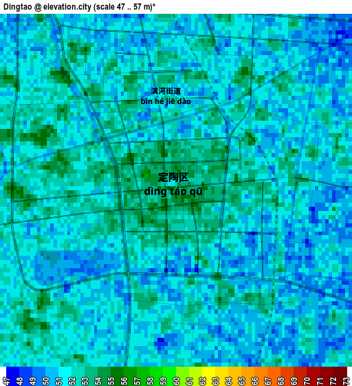
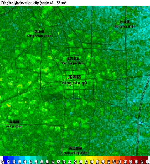
Below is the Elevation map of Dingtao, which displays elevation range with different colors. Scale of the first map is from 47 to 57 m (154 to 187 ft) with average elevation of 51.2 meters (=168 ft) [note 1]
These maps also provides idea of topography and contour of this city, they are displayed at different zoom levels. More info about maps, scale and edge coordinates you can find below images.
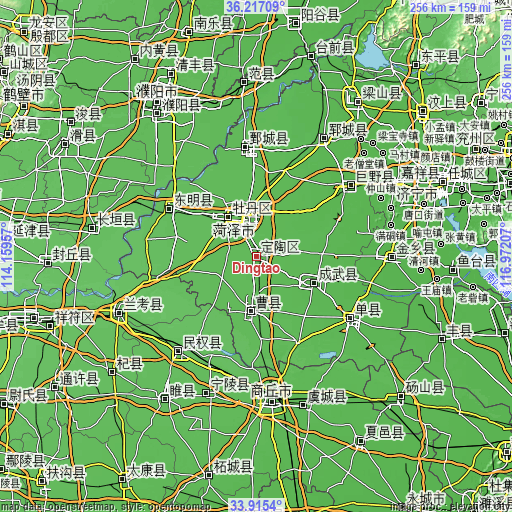
| \ | Map #1 | Map #2 | Topo.Map |
| Scale [m] | 47..57 m | 42..58 m | × |
| Scale [ft] | 154..187 ft | 138..190 ft | × |
| Average | 51.2 m = 168 ft | 50.4 m = 165 ft | × |
| Width | 8 km = 5 mi | 16 km = 9.9 mi | 255.9 km = 159 mi |
| Height | 8 km = 5 mi | 16 km = 9.9 mi | 255.9 km = 159 mi |
| ↑Max Latitude | 35.110317° | 35.146259° | 36.21709° |
| Latitude at center | 35.07436° | 35.07436° | 35.07436° |
| ↓Min Latitude | 35.038387° | 35.002398° | 33.9154° |
| ← Min Longitude | 115.521875° | 115.477929° | 114.15957° |
| Longitude center | 115.56582° | 115.56582° | 115.56582° |
| →Max Longitude | 115.609765° | 115.653711° | 116.97207° |
Nearby cities:
Cities around Dingtao sort by population:
• Heze elevation 53 m
20.2 km,  335°
335°
• Shangqiu 51 m
69.8 km,  173°
173°
• Shancheng 45 m
56.3 km,  123°
123°
• Juye 44 m
59.3 km,  53°
53°
• Ningling Chengguanzhen 59 m
73.1 km,  198°
198°
• Yuncheng 47 m
67.2 km,  29°
29°
• Minquan Chengguanzhen 63 m
60.3 km,  220°
220°
• Juancheng 52 m
54.5 km,  353°
353°
• Dongming Chengguanzhen 61 m
49.5 km,  299°
299°
• Chengguan 57 m
48.3 km, 302°
• Chengwu 47 m
31.9 km,  114°
114°
• Xicheng 55 m
22.6 km,  327°
327°
Multilingual:
 En español:
Dingtao elevación 53 m.
 En France:
Dingtao élévation 53 m.


Sources and notes:
- [note 1] Map square and city borders are not equal. Map elevation data is calculated only from area inside that square.
- [src 1] Elevation data from geonames database provided with same terms of usage.
- [src 2] The elevation map of Dingtao is generated using elevation data from NASA's 3 arcsec (90m) resolution SRTM data.
- [src 3] Base (background) map © OpenStreetMap contributors tiles are generated by Geofabrik and OpenTopoMap.
Copyright & License:
This Dingtao Elevation Map is licensed under CC BY-SA. You may reuse any part from this page, if you give a proper credit by linking to this URL:
 More info on terms of use page.