Dingxi elevation
Dingxi (Gansu, Dingxi Shi), China elevation is 1908 meters and Dingxi elevation in feet is 6260 ft above sea level [src 1]. Dingxi is a seat of a second-order administrative division (feature code) with elevation that is 1350 meters (4429 ft) bigger than average city elevation in China.
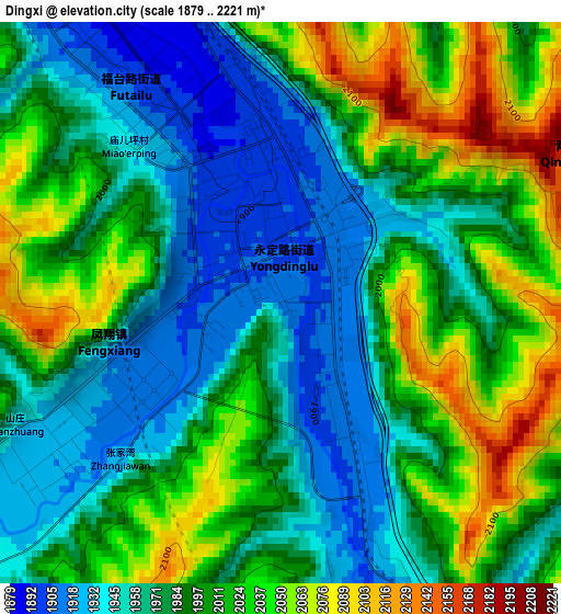
Below is the Elevation map of Dingxi, which displays elevation range with different colors. Scale of the first map is from 1879 to 2221 m (6165 to 7287 ft) with average elevation of 1992.9 meters (=6538 ft) [note 1]
These maps also provides idea of topography and contour of this city, they are displayed at different zoom levels. More info about maps, scale and edge coordinates you can find below images.
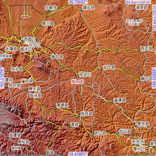
| \ | Map #1 | Topo.Map |
| Scale [m] | 1879..2221 m | × |
| Scale [ft] | 6165..7287 ft | × |
| Average | 1992.9 m = 6538 ft | × |
| Width | 7.95 km = 4.9 mi | 254.4 km = 158.1 mi |
| Height | 7.95 km = 4.9 mi | 254.4 km = 158.1 mi |
| ↑Max Latitude | 35.606617° | 36.70652° |
| Latitude at center | 35.57088° | 35.57088° |
| ↓Min Latitude | 35.535127° | 34.41891° |
| ← Min Longitude | 104.579085° | 103.21678° |
| Longitude center | 104.62303° | 104.62303° |
| →Max Longitude | 104.666975° | 106.02928° |
Nearby cities:
Cities around Dingxi sort by population:
• Lanzhou elevation 1521 m
88.9 km,  307°
307°
• Jingning Chengguanzhen 1663 m
99.7 km,  93°
93°
• Guanghe Chengguanzhen 1954 m
95.3 km,  264°
264°
• Xihu 1542 m
94.2 km, 305°
• Zhangyelu 1527 m
90.2 km, 306°
• Fucheng 2004 m
86 km, 255°
• Taoyang 1870 m
72.2 km,  254°
254°
• Pingxiang 1778 m
69.7 km,  125°
125°
• Qingyuan 2071 m
60.4 km,  216°
216°
• Yuzhong Chengguanzhen 1981 m
55.1 km,  303°
303°
• Huishi 1730 m
40.7 km,  70°
70°
• Zhonghualu 1889 m
4.5 km,  328°
328°
Multilingual:
 En español:
Dingxi elevación 1908 m.
 En France:
Dingxi élévation 1908 m.


Sources and notes:
- [note 1] Map square and city borders are not equal. Map elevation data is calculated only from area inside that square.
- [src 1] Elevation data from geonames database provided with same terms of usage.
- [src 2] The elevation map of Dingxi is generated using elevation data from NASA's 3 arcsec (90m) resolution SRTM data.
- [src 3] Base (background) map © OpenStreetMap contributors tiles are generated by Geofabrik and OpenTopoMap.
Copyright & License:
This Dingxi Elevation Map is licensed under CC BY-SA. You may reuse any part from this page, if you give a proper credit by linking to this URL:
 More info on terms of use page.