Huishi elevation
Huishi (Gansu), China elevation is 1730 meters and Huishi elevation in feet is 5676 ft above sea level [src 1]. Huishi is a seat of a third-order administrative division (feature code) with elevation that is 1172 meters (3845 ft) bigger than average city elevation in China.
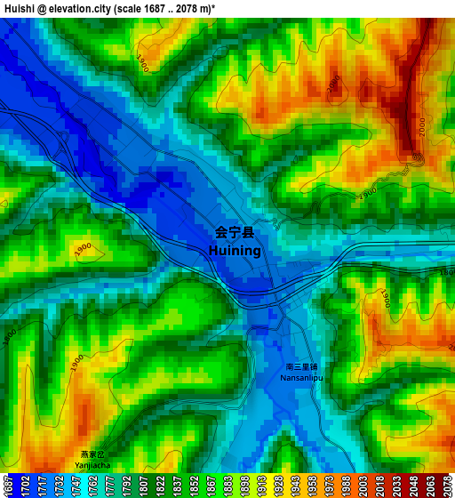
Below is the Elevation map of Huishi, which displays elevation range with different colors. Scale of the first map is from 1687 to 2078 m (5535 to 6818 ft) with average elevation of 1832.7 meters (=6013 ft) [note 1]
These maps also provides idea of topography and contour of this city, they are displayed at different zoom levels. More info about maps, scale and edge coordinates you can find below images.
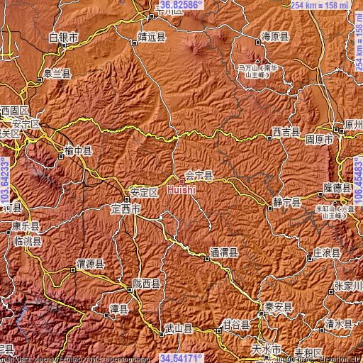
| \ | Map #1 | Topo.Map |
| Scale [m] | 1687..2078 m | × |
| Scale [ft] | 5535..6818 ft | × |
| Average | 1832.7 m = 6013 ft | × |
| Width | 7.94 km = 4.9 mi | 254 km = 157.8 mi |
| Height | 7.94 km = 4.9 mi | 254 km = 157.8 mi |
| ↑Max Latitude | 35.727643° | 36.82586° |
| Latitude at center | 35.69196° | 35.69196° |
| ↓Min Latitude | 35.656261° | 34.54171° |
| ← Min Longitude | 105.004635° | 103.64233° |
| Longitude center | 105.04858° | 105.04858° |
| →Max Longitude | 105.092525° | 106.45483° |
Nearby cities:
Cities around Huishi sort by population:
• Taoyang elevation 1870 m
112.9 km,  253°
253°
• Sanhe 1853 m
110.5 km,  28°
28°
• Gangu Chengguanzhen 1287 m
109.3 km,  166°
166°
• Xingguo 1219 m
108.4 km,  148°
148°
• Wulan 1408 m
102.5 km,  341°
341°
• Qingyuan 2071 m
97.1 km,  230°
230°
• Longde Chengguanzhen 2091 m
96.9 km,  95°
95°
• Yuzhong Chengguanzhen 1981 m
86.1 km,  281°
281°
• Jingning Chengguanzhen 1663 m
63.9 km,  107°
107°
• Pingxiang 1778 m
56.8 km,  161°
161°
• Zhonghualu 1889 m
42 km,  256°
256°
• Dingxi 1908 m
40.7 km, 250°
Multilingual:
 En español:
Huishi elevación 1730 m.
 En France:
Huishi élévation 1730 m.


Sources and notes:
- [note 1] Map square and city borders are not equal. Map elevation data is calculated only from area inside that square.
- [src 1] Elevation data from geonames database provided with same terms of usage.
- [src 2] The elevation map of Huishi is generated using elevation data from NASA's 3 arcsec (90m) resolution SRTM data.
- [src 3] Base (background) map © OpenStreetMap contributors tiles are generated by Geofabrik and OpenTopoMap.
Copyright & License:
This Huishi Elevation Map is licensed under CC BY-SA. You may reuse any part from this page, if you give a proper credit by linking to this URL:
 More info on terms of use page.