Dongguan elevation
Dongguan (Shanxi), China elevation is 983 meters and Dongguan elevation in feet is 3225 ft above sea level [src 1]. Dongguan is a seat of a third-order administrative division (feature code) with elevation that is 425 meters (1394 ft) bigger than average city elevation in China.
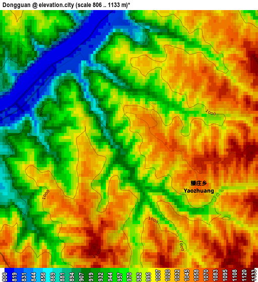
Below is the Elevation map of Dongguan, which displays elevation range with different colors. Scale of the first map is from 806 to 1133 m (2644 to 3717 ft) with average elevation of 984.1 meters (=3229 ft) [note 1]
These maps also provides idea of topography and contour of this city, they are displayed at different zoom levels. More info about maps, scale and edge coordinates you can find below images.
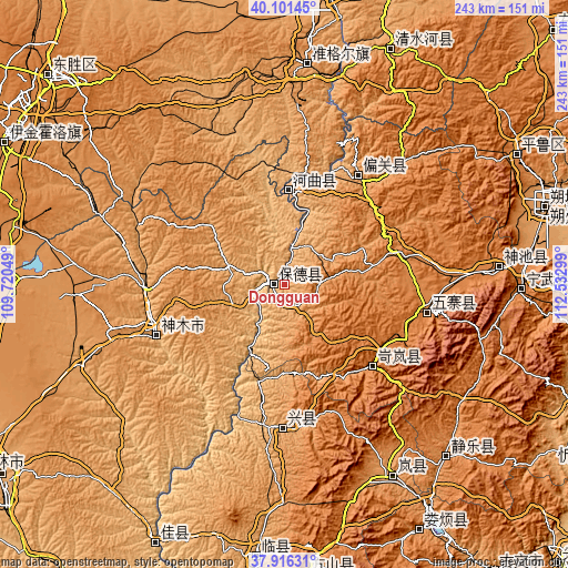
| \ | Map #1 | Topo.Map |
| Scale [m] | 806..1133 m | × |
| Scale [ft] | 2644..3717 ft | × |
| Average | 984.1 m = 3229 ft | × |
| Width | 7.59 km = 4.7 mi | 243 km = 151 mi |
| Height | 7.59 km = 4.7 mi | 243 km = 151 mi |
| ↑Max Latitude | 39.051455° | 40.10145° |
| Latitude at center | 39.01732° | 39.01732° |
| ↓Min Latitude | 38.983168° | 37.91631° |
| ← Min Longitude | 111.082795° | 109.72049° |
| Longitude center | 111.12674° | 111.12674° |
| →Max Longitude | 111.170685° | 112.53299° |
Nearby cities:
Cities around Dongguan sort by population:
• Jingping elevation 1373 m
114.2 km,  60°
60°
• Chengguan 1152 m
109.5 km,  25°
25°
• Echeng 1392 m
102.4 km,  134°
134°
• Fenghuang 1405 m
101.2 km,  91°
91°
• Xuejiawan 1138 m
94.8 km,  4°
4°
• Dongcun 1215 m
94.7 km,  148°
148°
• Longquan 1521 m
92.2 km, 85°
• Yancheng 1442 m
65.2 km,  100°
100°
• Weifen 1213 m
59.8 km,  176°
176°
• Xinguan 1261 m
59.8 km,  35°
35°
• Lanyi 1460 m
52.5 km, 129°
• Wenbi 957 m
41.5 km,  7°
7°
Multilingual:
 En español:
Dongguan elevación 983 m.
 En France:
Dongguan élévation 983 m.
 Auf Deutsch:
Dongguan höhe über dem Meeresspiegel ist 983 m.

Sources and notes:
- [note 1] Map square and city borders are not equal. Map elevation data is calculated only from area inside that square.
- [src 1] Elevation data from geonames database provided with same terms of usage.
- [src 2] The elevation map of Dongguan is generated using elevation data from NASA's 3 arcsec (90m) resolution SRTM data.
- [src 3] Base (background) map © OpenStreetMap contributors tiles are generated by Geofabrik and OpenTopoMap.
Copyright & License:
This Dongguan Elevation Map is licensed under CC BY-SA. You may reuse any part from this page, if you give a proper credit by linking to this URL:
 More info on terms of use page.