Dongcun elevation
Dongcun (Shanxi), China elevation is 1215 meters and Dongcun elevation in feet is 3986 ft above sea level [src 1]. Dongcun is a seat of a third-order administrative division (feature code) with elevation that is 657 meters (2156 ft) bigger than average city elevation in China.
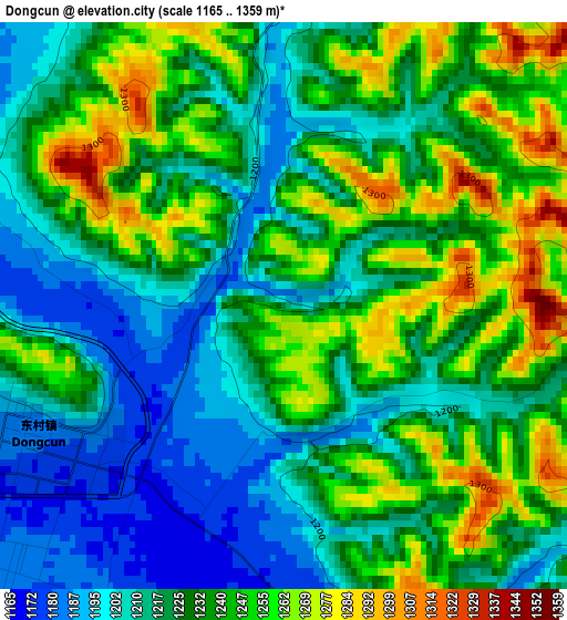
Below is the Elevation map of Dongcun, which displays elevation range with different colors. Scale of the first map is from 1165 to 1359 m (3822 to 4459 ft) with average elevation of 1229.4 meters (=4033 ft) [note 1]
These maps also provides idea of topography and contour of this city, they are displayed at different zoom levels. More info about maps, scale and edge coordinates you can find below images.
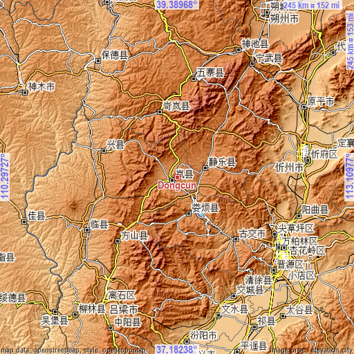
| \ | Map #1 | Topo.Map |
| Scale [m] | 1165..1359 m | × |
| Scale [ft] | 3822..4459 ft | × |
| Average | 1229.4 m = 4033 ft | × |
| Width | 7.67 km = 4.8 mi | 245.4 km = 152.5 mi |
| Height | 7.67 km = 4.8 mi | 245.4 km = 152.5 mi |
| ↑Max Latitude | 38.328902° | 39.38968° |
| Latitude at center | 38.29442° | 38.29442° |
| ↓Min Latitude | 38.259922° | 37.18238° |
| ← Min Longitude | 111.659575° | 110.29727° |
| Longitude center | 111.70352° | 111.70352° |
| →Max Longitude | 111.747465° | 113.10977° |
Nearby cities:
Cities around Dongcun sort by population:
• Qianfeng elevation 789 m
87 km,  124°
124°
• Huangzhai 896 m
87 km,  106°
106°
• Julun 815 m
86.2 km, 119°
• Chaicun 834 m
78.7 km, 120°
• Yancheng 1442 m
70.5 km,  11°
11°
• Linquan 1036 m
69.2 km,  239°
239°
• Dongqu 971 m
60.2 km,  133°
133°
• Gedong 1268 m
59.4 km,  221°
221°
• Weifen 1213 m
51.2 km,  293°
293°
• Lanyi 1460 m
48.2 km,  348°
348°
• Echeng 1392 m
25 km,  69°
69°
• Loufan 1248 m
24.3 km,  158°
158°
Multilingual:
 En español:
Dongcun elevación 1215 m.
 En France:
Dongcun élévation 1215 m.
 Auf Deutsch:
Dongcun höhe über dem Meeresspiegel ist 1215 m.

Sources and notes:
- [note 1] Map square and city borders are not equal. Map elevation data is calculated only from area inside that square.
- [src 1] Elevation data from geonames database provided with same terms of usage.
- [src 2] The elevation map of Dongcun is generated using elevation data from NASA's 3 arcsec (90m) resolution SRTM data.
- [src 3] Base (background) map © OpenStreetMap contributors tiles are generated by Geofabrik and OpenTopoMap.
Copyright & License:
This Dongcun Elevation Map is licensed under CC BY-SA. You may reuse any part from this page, if you give a proper credit by linking to this URL:
 More info on terms of use page.